
Hohlstedt (Wallhausen)
|
Hohlstedt
Municipality Wallhausen
Coordinates: 51 ° 27 '33 " N , 11 ° 9' 59" E
|
|
|---|---|
| Height : | 141 m above sea level NHN |
| Incorporation : | July 1, 1973 |
| Postal code : | 06528 |
| Area code : | 034656 |
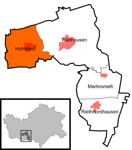  Location of Hohlstedt in Wallhausen
|
|
Hohlstedt has been part of the community of Wallhausen in the district of Mansfeld-Südharz in Saxony-Anhalt , Germany , since 1973 .
geography
The village is located on the Helme , about three kilometers west of Wallhausen on the road to Bennungen in the Golden Aue between Sangerhausen and Nordhausen . The federal motorway 38 runs north of the village . On the road to Brücken is the Schwedenkreuz, an old sandstone cross that was stolen in the winter of 2008/09 but was found intact.
history
In 957, Hohlstedt was first mentioned in a document as a Haul test. The Church of St. Andrew dates from the 12th century. From 1585 to 1626 the plague raged in the village several times and led to around 300 deaths. In the Thirty Years War (1618-1648) 34 of 40 houses were destroyed. Settlement houses were built in Hohlstedt in the 1920s and 1930s. During the Second World War , from January 16 to March 27, 1945, there was a subcamp of the Dora-Mittelbau concentration camp in the community restaurant , whose prisoners were used for forced labor. In a major fire in 1950, five farmsteads were destroyed to the ground.
graveyard
In the cemetery there is a war memorial for those who died in Hohlstedt in the First and Second World Wars.
Sons and daughters of the place
- Dagmar Szabados (born November 10, 1947), SPD politician, former mayor of the city of Halle (Saale)