
Riethnordhausen (Wallhausen)
|
Riethnordhausen
Municipality Wallhausen
Coordinates: 51 ° 25 ′ 15 ″ N , 11 ° 14 ′ 8 ″ E
|
|
|---|---|
| Height : | 134 m above sea level NHN |
| Area : | 6.79 km² |
| Residents : | 562 (Dec. 31, 2007) |
| Population density : | 83 inhabitants / km² |
| Incorporation : | July 1, 2009 |
| Postal code : | 06528 |
| Area code : | 034656 |
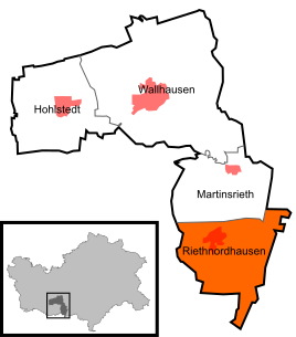  Location of Riethnordhausen in Wallhausen
|
|
Riethnordhausen is a district of the municipality Wallhausen in the district of Mansfeld-Südharz in Saxony-Anhalt , Germany.
Geographical location
Riethnordhausen is located in the Rieth in the lower Helmetal , northeast of the Kyffhauser and southwest of the district town Sangerhausen , from which a connecting road leads into the place, which crosses here with the road leading from Kelbra to Artern .
history
Riethnordhausen belonged to the Sangerhausen office in the Kingdom of Saxony until 1815 and then came to the Merseburg administrative district of the Prussian province of Saxony . From 1952 to 1990 Riethnordhausen belonged to the GDR district of Halle.
On July 1, 2009, the previously independent communities Riethnordhausen and Martinsrieth were incorporated into Wallhausen.
politics
coat of arms
The coat of arms was designed by the heraldist Lutz Döring .
Personalities
- Friedrich Hermann Wölfert (1850–1897), publisher and aviation pioneer