
Werther (Thuringia)
| coat of arms | Germany map | |
|---|---|---|
.svg)
|
Coordinates: 51 ° 30 ' N , 10 ° 41' E |
|
| Basic data | ||
| State : | Thuringia | |
| County : | Nordhausen | |
| Height : | 213 m above sea level NHN | |
| Area : | 61.94 km 2 | |
| Residents: | 3166 (Dec. 31, 2019) | |
| Population density : | 51 inhabitants per km 2 | |
| Postal code : | 99735 | |
| Primaries : | 03631,036332, 036335, 036337 | |
| License plate : | NDH | |
| Community key : | 16 0 62 063 | |
| LOCODE : | DE WXW | |
| Community structure: | 8 districts | |
| Address of the municipal administration: |
Dorfstrasse 18 99735 Werther |
|
| Website : | ||
| Mayor : | Hans-Jürgen Weidt | |
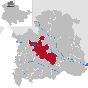
| Location of the municipality of Werther in the Nordhausen district | ||
  |
||


Werther is a municipality (with almost 3300 inhabitants) and a district (with 1450 inhabitants) in the Nordhausen district in Thuringia in Germany .
geography
The municipality of Werther is located in the Helme Valley , in the Nordhäuser Buntsandsteinland , a region of the northern Thuringian hill country . It borders the Goldene Aue in the southeast . The district town of Nordhausen is about 2 km to the east.
Community structure
The municipality of Werther includes eight places that emerged from the former Helmetal administrative community . These include:
- Major changes with 860 inhabitants and the associated hamlet of Schern
- Günzerode (270 inhabitants)
- Oats (170 inhabitants)
- Immenrode (120 inhabitants) and the associated hamlet of Fronderode
- Kleinwechselungen (330 inhabitants) and the Flarichsmühle
- Mauderode (156 inhabitants)
- Pützlingen (170 inhabitants)
- Werther with the districts
- Kleinwerther (in the north)
- Großwerther (in the south)
- Schate (south of Großwerther)
history
The place was first mentioned in a deed of donation from Archbishop Ruthard of Mainz in 1093. The name is a variant of the North German Werder (= island), which can be explained by the drainage of the surrounding area by Cistercian monks of the Walkenried monastery in the 12th century.
In the district of Kleinwerther, on the site of the former castle (still existing today) of the manor, there was a moated castle, which was built in the 11th century and destroyed in the Peasants' War in 1525. Three barrel cellars under the still existing manor house and remains of the moat bear witness to the facility. The Lords of Werthern were mentioned in a document in 1209.
The new farmers ' settlement "Schate", which was laid out in 1945, is a district of Werther . It is located barely a thousand meters south of the location at the foot of the Siechenberg and goes back to the independent church village "Schate", which was formerly located there and was first mentioned in a document in 1266. but it was already described as a desert in 1506 .
During the Second World War , 500 and at times up to 950 prisoners of the Mittelbau-Dora concentration camp had to do grueling forced labor to build the Helmetalbahn . Since 1995 a memorial plaque on the former sheepfold, where they were housed, has been commemorating the Nazi crimes. In March 1945, the SS set up a Mittelbau-Dora concentration camp external command in Großwerther, which housed 300 predominantly Jewish women on the intermediate stop on their death march from the Groß Rosen concentration camp to the Mauthausen concentration camp . In addition, at least 145 foreign women and men had to do forced labor since the beginning of the war: in the agriculture of Immenrode, on the estate in Großwechselung , in Kleinwerther, in Großwerther and on the domain of the Rühmkorf brothers in Günzerode .
On January 1st, 1997, the places Großwechselungen, Günzerode, Haferungen, Immenrode, Kleinwechselungen, Mauderode and Pützlingen were incorporated into Werther. At the same time, the Helmetal administrative community , to which all municipalities and the Hesserode municipality belonged, was dissolved.
On February 13, 2015, Fronderode moved from the Friedrichsthal community to the Werther community.
Population development
Development of the population:
|
|
|
|
Data source: from 1994 Thuringian State Office for Statistics - values from December 31st
Municipal council
The municipal council in Werther consists of 16 council members:
- CDU 4 seats
- BBW "Round Table" Werther 4 seats
- The left 2 seats
- SPD 2 seats
- Citizens' initiative "Open Helmetal" 2 seats
- "Fire brigade & more" 2 seats
(Status: Local elections in Thuringia on May 26, 2019)
Attractions
- St. Nikolai in Großwerther
- St. Philip in Kleinwerther
- St. Peter and Paul in large exchanges
- St. Andreas in Günzerode
- St. Andrew in oats
- Village church in Immenrode
- St. Michaelis in Pützlingen
- Village church in small changes
Economy and Infrastructure
There are two industrial parks in the Werther community. One of them is located in the Werther “Am Mühlweg” district - directly on the former B 80 and 100 m from the junction of the A 38. The commercial area is 90% occupied. The second commercial area is located in the district of Großwechselungen “Hinter der Aue” - this can be reached via the B 243. There are still vacant spaces in this industrial park that are privately owned.
Transport links
Werther can be reached via the federal highways 243 and 80 as well as the A 38 (so-called Südharztangente ). The place has a stop in the district of Großwerther on the Halle – Hann railway line. Münden .
Personalities
- Friedrich Georg Tuve (1759–1830), Evangelical Lutheran pastor
- Eberhard Herwarth von Bittenfeld (1796–1884), Prussian Field Marshal General
- Richard Quelle (1870–1926), publisher
- Walter Steinecke (1888–1975), politician (NSDAP)
- Selmar Bühling (1895–1977), lawyer, politician, founder of the Erfurt loyalty association
literature
- Hermann Linsel: 900 years of Kleinwerther . In: Meyenburg Museum (ed.): Contributions to local history from the city and district of Nordhausen . Issue 18. Nordhausen 1993, p. 93-105 .
Web links
Individual evidence
- ^ Population of the municipalities from the Thuringian State Office for Statistics ( help on this ).
- ↑ M. Köhler Thuringian castles and fortified prehistoric and protohistoric residential areas Jenzig-Verlag 2001 S 273 ISBN 3-910141-43-9
- ↑ Hans-Jürgen Gröncke: New settlement finds from Schate . In: Meyenburg-Museum (Hrsg.): Contributions to local history from the city and district of Nordhausen . Issue 11. Nordhausen 1986, p. 59-60, p. 62 - Note 9 .
- ↑ Thuringian Association of the Persecuted of the Nazi Regime - Association of Antifascists and Study Group of German Resistance 1933-1945 (Ed.): Heimatgeschichtlicher Wegweiser zu places of resistance and persecution 1933-1945, series: Heimatgeschichtliche Wegweiser Volume 8 Thüringen, Erfurt 2003, p. 201f ., ISBN 3-88864-343-0
- ^ StBA: Changes in the municipalities, see 1997
- ↑ Fronderode is now part of Werther , Thüringer Allgemeine, accessed on February 14, 2015
Major changes (with scissors ) | Günzerode | Oats | Immenrode (with Fronderode ) | Small changes (with Flarichsmühle ) | Mauderode | Pützlingen | Werther (with Kleinwerther , Großwerther and Schate )
Bleicherode | Ellrich | Görsbach | Großlohra | Harz Gate | Pegs / helmets | Hohenstein | Kehmstedt | Kleinfurra | Lipprechteode | Niedergebra | Nordhausen | Sollstedt | Urbach | Werther