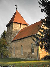
Kleinfurra
| coat of arms | Germany map | |
|---|---|---|

|
Coordinates: 51 ° 25 ' N , 10 ° 46' E |
|
| Basic data | ||
| State : | Thuringia | |
| County : | Nordhausen | |
| Fulfilling municipality : | Bleicherode | |
| Height : | 205 m above sea level NHN | |
| Area : | 18.61 km 2 | |
| Residents: | 1039 (Dec. 31, 2019) | |
| Population density : | 56 inhabitants per km 2 | |
| Postal code : | 99735 | |
| Area code : | 036334 | |
| License plate : | NDH | |
| Community key : | 16 0 62 026 | |
| Address of the municipal administration: |
Hauptstrasse 37 99752 Bleicherode |
|
| Mayor : | Benno Koschorreck | |
| Location of the community of Kleinfurra in the Nordhausen district | ||
Kleinfurra is a municipality in the Thuringian district of Nordhausen . The fulfilling municipality is the city of Bleicherode .
location
Kleinfurra is located at the foot of the Hainleite , a small mountain range in the north of Thuringia, in the Wipper valley . The district town of Nordhausen is not far to the north. To the east of Kleinfurra are the cities of Sondershausen and to the west of Bleicherode. With over 1000 inhabitants (December 31, 2018), Kleinfurra is one of the larger villages in the Nordhausen district. In Kleinfurra, the periodically water-bearing Wernröder Bach flows into the Wipper.
history
Kleinfurra was first mentioned in a document from 822 to 842. The manor was managed by the Telemann families, later Herrmanns (historical gravestones in the cemetery). The village is traditionally agricultural, although the way to work was never far away thanks to the cheap rail connection.
On July 1, 1950, the previously independent municipality of Rüxleben was incorporated.
As everywhere in the GDR, from 1952 the farmers took the path of collectivization. After the reunification they found new forms of farm labor. In 2012, 500 people lived in the village.
politics
Districts
The districts of Hain and Rüxleben belong to Kleinfurra .
Municipal council
The municipality council in Kleinfurra consists of twelve council members:
- CDU 3 seats
- BI 4 seats
- FW 5 seats
(As of: local elections on May 24, 2014)
coat of arms
Description : "In silver a green angular shield head, covered with a silver linden leaf, underneath each accompanied by a green linden leaf, underneath in the shield base a blue wavy bar."
Infrastructure
traffic
Kleinfurra has a train station on the Nordhausen – Erfurt railway line . In the vicinity of Kleinfurra, the state road 1034 from Sondershausen to Wipperdorf crosses with the state road 2083 Nordhausen - Immenrode . In the vicinity of the district of Hain, the federal road 4 leads along.
Buildings
- Biogas plant at the Rüxleben cowshed
- Kleinfurra animal cemetery
- Youth club Kleinfurra / Rüxleben
- St. Anne's Church
societies
- Kirmesburschen Rüxleben
- Sports club SV Kleinfurra 1911 e. V.
- Volunteer Fire Brigade Rüxleben e. V.
- Fair-boys Kleinfurra
- Hundesportortsverein Kleinfurra eV
- Choir community Kleinfurra / Rüxleben
Sons and daughters of the church
- Hartmut Renner (born December 18, 1951), metal sculptor
Web links
Individual evidence
- ^ Population of the municipalities from the Thuringian State Office for Statistics ( help on this ).
- ^ Wolfgang Kahl : First mention of Thuringian towns and villages. A manual. Verlag Rockstuhl, Bad Langensalza 2010, p. 144, ISBN 978-3-86777-202-0 .
- ↑ Kleinfurra - www.vg-hainleite.de. Retrieved October 20, 2018 .


