Niedergebra
| coat of arms | Germany map | |
|---|---|---|
 Help on coat of arms |
Coordinates: 51 ° 25 ' N , 10 ° 36' E |
|
| Basic data | ||
| State : | Thuringia | |
| County : | Nordhausen | |
| Fulfilling municipality : | Bleicherode | |
| Height : | 240 m above sea level NHN | |
| Area : | 9.99 km 2 | |
| Residents: | 654 (Dec. 31, 2019) | |
| Population density : | 65 inhabitants per km 2 | |
| Postal code : | 99759 | |
| Area code : | 036338 | |
| License plate : | NDH | |
| Community key : | 16 0 62 037 | |
| Address of the municipal administration: |
Parkstrasse 273 99759 Niedergebra |
|
| Mayoress : | Burgundy Krumm ( CDU ) | |
| Location of the community Niedergebra in the district of Nordhausen | ||
Niedergebra is a municipality in the Nordhausen district in Thuringia . The town of Bleicherode is the fulfilling municipality for Niedergebra .
geography
The community lies between the Bleicheröder mountains and the Hainleite in the Wippertal on the Halle – Hann railway line. Münden .
history
The place was first mentioned in 1162.
The Counts of Hagen exerted a significant influence on the place and its development. Baron Friedrich Philipp vom Hagen (1683–1754) was district administrator of the County of Hohnstein, which was under Prussian rule, and had the Niedergebra Castle built for him from 1725 to 1735 . The son of Baron Friedrich Philipps von Hagen, Baron Ludwig Philipp von Hagen (1724–1771) was appointed by Frederick the Great as a "Real Secret Budget, War and Conducting Minister at the General Directorate". Thus he was placed at the head of the Prussian state administration. He carried out important reforms and improvements in administration.
Another building in Niedergebra that is worth mentioning is the so-called Apostle Bridge . It was built from stones from the demolished main tower of Amt Lohra . It was once the first bridge to be used over the Wipper. It was built around 1670 by the Count of Sayn-Wittgenstein, who owned the county at that time. Since it was in danger of collapsing in 1751, the bridge was rebuilt at royal expense. The stone substructure dates from 1803. The current bridge dates from 1850. In 1950, the western vault was renewed by the Niedergebra community. According to a legend, the name Apostelbrücke is traced back to Boniface, who allegedly preached here. But it is also possible that it is the modified expression of "Bosselebner" (Pustleben) bridge, since the road leads over the bridge to Pustleben . The bridge was rebuilt and reopened on August 31, 2013. Today there are u. a. a time table and seating in front of the Apostle Bridge.
During the Second World War in 1944, 40 concentration camp prisoners produced A4 rocket parts in a barrack of the Fieseler-Werke . From July 1, 1950 to May 5, 1984 Niedergebra was merged with Obergebra to form the Gebra / Hainleite community.
Today trade, crafts and agriculture determine the economic structure of the municipality. There is a commercial area on the B 80 . There is a gas station and a car dealership here. A children's village with four houses run by the Nordhausen youth welfare organization has settled in Niedergebra. Approx. 40 children have found a home here.
Every year there is a spring market and an autumn market in Niedergebra.
In 2012 Niedergebra celebrated its 850th anniversary.
politics
Municipal council
The municipal council in Niedergebra consists of eight council members:
- Free voters 3 seats
- CDU 5 seats
(As of: local elections on June 7, 2009)
Attractions
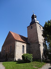
- St. Nicolai Church
- Apostelbrücke, it was one of the first navigable bridges over the Wipper
- Moated castle in Niedergebra , built between 1725 and 1732
societies
Voluntary fire brigade, Kirchbauverein Niedergebra eV, SV Eintracht, Förderverein Apostelbrücke e. V., men's choir "Harmonie", rifle club, income tax aid association
Personalities
- Egon Primas , politician (CDU)
Web links
- Niedergebra
- Photos of the castle
- Material on Niedergebra Castle in the Duncker Collection of the Central and State Library Berlin (PDF; 234 kB)
Individual evidence
- ^ Population of the municipalities from the Thuringian State Office for Statistics ( help on this ).
- ↑ Thuringian Association of the Persecuted of the Nazi Regime - Association of Antifascists and Study Group of German Resistance 1933–1945 (ed.): Heimatgeschichtlicher Wegweiser to sites of resistance and persecution 1933–1945, series: Heimatgeschichtliche Wegweiser Volume 8 Thüringen, Erfurt 2003, p. 191 , ISBN 3-88864-343-0
- ↑ 2. Ordinance amending the district and community boundaries in the state of Thuringia from June 26, 1950
- ↑ GenWiki: Gebra / Hainleite ( page no longer available , search in web archives ) Info: The link was automatically marked as defective. Please check the link according to the instructions and then remove this notice.


