
Wipper (Unstrut)
| Rocker | ||
.png) The catchment area of the Wipper |
||
| Data | ||
| Water code | EN : 5646 | |
| location | Thuringia , Germany | |
| River system | Elbe | |
| Drain over | Unstrut → Saale → Elbe → North Sea | |
| source | in Worbis im Eichsfeld 51 ° 25 ′ 17 ″ N , 10 ° 21 ′ 36 ″ E |
|
| Source height | 333 m above sea level NN | |
| muzzle |
Unstrut near Sachsenburg Coordinates: 51 ° 17 ′ 21 ″ N , 11 ° 9 ′ 58 ″ E 51 ° 17 ′ 21 ″ N , 11 ° 9 ′ 58 ″ E
|
|
| length | 88 km (including the Ritterbach as the longest source river, approx. 96 km) | |
| Catchment area | 646.5 km² | |
| Discharge at the Hachelbich A Eo gauge : 524 km² Location: 29.4 km above the mouth |
NNQ (19.11.2008) MNQ 1962-2014 MQ 1962-2014 Mq 1962-2014 MHQ 1962-2014 HHQ (20.04.1983) |
100 l / s 909 l / s 3.18 m³ / s 6.1 l / (s km²) 29.9 m³ / s 81.2 m³ / s |
| Left tributaries | u. a. Rhin, Friede, Bode | |
| Right tributaries | u. a. Without, Aue, Bebra, Wirbelbach | |
| Medium-sized cities | Leinefelde-Worbis , Sondershausen | |
| Small towns | Bleicherode , Kindelbrück | |
The Wipper is a good 88 km, with the longest source stream Ritterbach 96 km long, left and westerly and the longest tributary of the Unstrut in northern Thuringia , Germany . It is also the second longest river that runs entirely in Thuringia and the longest whose catchment area is only in Thuringia. The Wipper including the oxbow lakes of the districts Kannawurf and Kindelbrück belong to the first order waters according to the Thuringian Water Act from the Flutgraben junction in Worbis to the confluence with the Unstrut .
The Wipper still carries salt with it due to the former potash mining in the area; it is classified as "moderately polluted" ( water quality class II) over the entire course of the river . This salt load is brought in in a controlled manner through the saline tailings waste water and through the caustic stack basin in Wipperdorf.
geography
Headwaters

The Wipper rises in the Eichsfeld district at the foot of the Ohm Mountains from several sources in the city center of Worbis . One of the main sources is located in Braustraße under the city gymnasium and has been enclosed. A second, longer source branch flows down from Kirchohmfeld as a flood ditch , takes in the Ritterbach from the direction of Kaltohmfeld in the urban area , before it flows into the Wipper shortly after the source area.
About one kilometer west of the Wipper springs are the Hahle springs , which are part of the Weser river system . Both source areas on the Elbe-Weser watershed belong to the geological structure of the Worbiser Trench in the Ohmgebirgs trench zone .
course
From Worbis the Wipper flows mainly in an easterly direction. At Sollstedt the river leaves the Eichsfeld through the Eichsfeld gate to the Nordhausen district . The Wipper valley is then flanked to the south by the Hainleite ridge . The most important town on the river Wipper is Sondershausen , the district town of the Kyffhäuserkreis . From Göllingen , where the Kleine Wipper branches off, it turns to the southeast and cuts through the Hainleite at Seega at the Wipper breakthrough . The Wipper flows into the Unstrut near Sachsenburg at the Thuringian Gate .
Tributaries
The following rivers, mostly streams, flow to the Wipper (in brackets the tributary side and, if known, the length and catchment area ; streams with less than 10 km² in lower case):
- Flutgraben (with the Ritterbach) (L) in Worbis
- Black Water (L) in Gernrode (Eichsfeld)
- Roast water (R) in Gernrode (Eichsfeld)
- Striemenwasser (R) in Gernrode (Eichsfeld)
- Without (R; 14 km; 69.0 km²) between Gernrode and Bernterode
- Rohrbach (R) between Gernrode and Bernterode
- Aue ( Bach from Gerterode ; R) between Gernrode and Bernterode
- Rhin ( Lache ; L) near Bernterode
- Rehunger Bach (R) in Wülfingerode
- Friede (L; 2.5 km) in Sollstedt
- Renkgraben (Bach from Friedrichslohra ; R; 3.67 km) west of Elende
- Bode (L; 20 km; 105.0 km²) in Bleicherode- East
- Rennebach (L; 1.8 km) in Wipperdorf
- Rodegraben (Bach coming from Mörbach; L) near Nohra
- Mühlgraben (R; 1.1 km) on the northern boundary of Nohra
- Riethgraben (Bach coming from Nohra; R; 1.3 km) near Wollersleben
- Teichbach (R; 6.6 km) near Wollersleben
- Spülgraben (L; 0.8 km) and Tiefenbach via Mühlgraben near Wollersleben
- Wernröder Bach (R) near Kleinfurra
- Passberggraben (lower course: blade ; L) near Sondershausen - Stockhausen
- Bebra (R: 31.7 km²) near Sondershausen
- Hachel (R) in Hachelbich
- Wirbelbach (R; 44.3 km²) below Bilzingsleben
- Käsebach (R) near Kindelbrück
Origin of name
Elfriede Ulbricht saw here an origin from Middle Low German , Dutch or Middle English Wippen. According to this, the river name is used 15 times in Germany, also in variations such as Wipfer . The basic word was originally aha (a variant of -au ). This was weakened in the late 10th century on -a and in the early 11th century on -e and then disappeared completely at the Wipper . In other rivers of this name, the -a or -e was preserved. The name would be made up of rotating, rotating, swaying movement and water (in the sense of flowing water).
Felix Solmsen and Ernst Fraenkel assumed a very similar meaning, but saw the root of the name with an even older, Indo-European origin and translate the river name as the hopping .
A completely different explanation is based on the naming of the river after Saint Wigbert (Latin: Wipertus or Wippertus), who did missionary work in this area. The monastery of Göllingen , which is located directly on the lower course of the river, was also consecrated to Saint Wigbert .
Some names along the river are derived from the Wipper, for example the Eichsfeld-Wipperaue administrative community , the Wippertal, the village of Wipperdorf and the Wipperbruchbruch.
Economy and tourism
Attractions
- Worth seeing small town Worbis at the source with half-timbering, baroque Antonius church , rent office, museum "Güldenes Kreuz" and alternative bear park.
- Numerous watermills along the entire course of the river (Büschlebs-Mühle, Neue Mühle, Rieth Mühle, Ipp Mühle, Kestings Mühle, Seeboths Mühle, Wendelröder Mühle, Schwarzburger Mühle, Schwert'sche Mühle) and first tributaries
- Sondershausen, the district town of the Kyffhäuserkreis with castle , city fortifications, adventure mine and technical monument Petersenschacht
- Göllingen monastery church with Romanesque church tower and crypt
- Wipper breakthrough with remains of the Arnsburg south of Seega
- Kindelbrück with city fortifications and the Gründelsloch karst spring
Water hiking
When the water level is high (usually from November to April), paddle boats can be used on the Wipper from the mouth of the river Bleicherode Ost. However, there are many shallow water areas and weirs that have to be moved. The weirs are all dangerous and not passable. There are no locks. The section from the Göllingen weir to Kindelbrück is particularly popular, as it leads through the scenic Wipper breakthrough and there are no weirs there. The water hike on the Unstrut can be continued at the mouth of the Wipper in Sachsenburg. This already has a good infrastructure for boats, such as entry points and locks.
Picture gallery
The images are ordered downstream.

Wipper in Worbis
Wipper near the monastery in Worbis

Former Wipperwehr in Gernrode (2007)

Wipper in Sollstedt when the snow melts

The seesaws at the sports field in Nohra

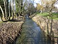
Wipper in Wollersleben

The Wipper in Sondershausen

The Wipper in Sondershausen


_in_Wollersleben.jpg)


Web links
Individual evidence
- ^ River lengths in Thuringia - State Institute for Environment and Geology.
- ^ A b Thuringian State Institute for the Environment (ed.): Area and waterway key figures (directory and map). Jena 1998. 26 pp.
- ↑ German Hydrological Yearbook Elbe Area, Part I 2014. (PDF) State Office for Flood Protection and Water Management Saxony-Anhalt, p. 179 , accessed on November 3, 2018 (from: lhw.sachsen-anhalt.de).
- ↑ http://www.tlug-jena.de/uw_raum/umweltregional/thueringen/maps/gewaesserguete_06.pdf
- ↑ Frank Voß: Integrated modeling of flow dynamics and saline mass transport processes taking into account anthropogenic controls using the Unstrut as an example . 2006
- ↑ Map of the rivers of Thuringia from 10 km² catchment area ( Memento from July 19, 2011 in the Internet Archive ) (PDF; 1.23 MB)
- ↑ Elfriede Ulbricht: The river basin of the Thuringian Saale . 1st edition. Max Niemeyer, Halle (Saale) 1957.
- ↑ Felix Solmsen. Ed. U. edit by Ernst Fraenkel: Indo-European proper names as a mirror of cultural history . 1st edition. Carl Winter, Heidelberg 1922.