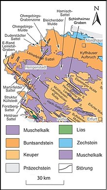
Ohmgebirgs rift zone
The Ohmgebirgs grave zone is a saxonic , ie from north-northwest to south-southeast, geological fault zone on the border of the Bleicherode – Stadtrodaer plaice in the east and the Eichsfeld plaice in the west. It delimits the Thuringian Basin and its northern edge plates to the northwest.
structure
The fault zone runs from the north near Weißenborn-Lüderode over the Ohmgebirge to the Dün near Kallmerode and is part of the Ohmgebirgs-Mulde . It consists of the Holunger Graben in the northeast and the Worbiser Graben in the southwest.
Holunger Graben
The Holunger Graben begins near Weißenborn-Lüderode as a shell limestone ridge with the Winkelberg (415 m), runs over the Krantberg (455 m) and the Sonnenstein (484 m) and ends at the edge of the Ohmgebirgsplateau. Upstream to the north are two small fault zones, the Iberggraben and the Allerburggraben south of Bockelnhagen .
Worbiser Graben
The Worbiser Graben begins as a depression of the Ohmgebirgsplateau near Kaltohmfeld along the Ritterbach (Sachsental) and runs from Worbis again as a limestone ridge with the Klien (409 m), the immediate locality of Breitenbach and Leinefelde further over the Richteberg (377 m) and the Eulenberg ( 388 m) and ends at the northern edge of the Dün near Kallmerode. This part of the rift zone separates the Eichsfelder Kessel in the east from the rest of the Eichsfeld hill country in the west.
geology
The grave zone was initially created as a depression within the shell limestone (recognizable north of Worbis) and at the same time as an elevation in the surrounding red sandstone landscape due to reduced weathering . Isolated chalk deposits on layers of shell limestone in the Holunger Graben (west of Holungen, southwest of Gerode) and the Keuper in the Worbiser Graben (near Kaltohmfeld ) are of geological interest . The presence of solid limestone is more common here (e.g. at Klien ). The typical Zechstein for northern Thuringia does not exist here.
Waters
The Ohmgebirgs rift zone forms part of the Elbe-Weser watershed between the Harz Mountains and the northwestern edge plates of the Thuringian Basin. The southern part in particular is a water-rich area with the headwaters of the Wipper , Hahle , Ohne and Leine . At the Holunger Graben there are also numerous headwaters , such as the Geroder Eller , the Jütze and the Soolbach .
Individual evidence
- ^ D. Franke: Regionalgeologie Ost - Geological online lexicon for East Germany
literature
- Langbein, R. and Seidel, G .: On the geology in the area of the Holunger Graben (Ohmgebirgsgrabenzone) Geologie, 9 (1): 36–57, Berlin
- Heinz-Martin Möbus: Allochthonous Triassic clods on the Unterwerrasattel as the key to understanding Saxon grave tectonics Dissertation Marburg 2004 (The Ohmgebirgsgrabenzone page 166-167) PDF
- Klaus Köhler, Eckard Speetzen: The Braune Bühl on the northern edge of the Ohm Mountains - a geological specialty. In: Eichsfeld-Jahrbuch 21 (2013), pp. 391–400
- Heinz-Gerd Röhling: Formation and structure of the Upper Cretaceous deposits in the Ohm Mountains (Eichsfeld). In: Eichsfeld-Jahrbuch 13th year (2005), Verlag Mecke Duderstadt
- Christian Kreher, Olaf Elicki and Michael Magnus: A foraminifera microfauna from the Upper Cretaceous Mountains of the Ohm Mountains (NW Thuringia): Morphotypes and facial relevance. Paläontologie, Stratigraphie, Fazies (21), Freiberger Forschungshefte, C 545, pp. 1–13

