
Leinefelde-Worbis
| coat of arms | Germany map | |
|---|---|---|

|
Coordinates: 51 ° 25 ' N , 10 ° 20' E |
|
| Basic data | ||
| State : | Thuringia | |
| County : | Eichsfeld | |
| Height : | 365 m above sea level NHN | |
| Area : | 115.79 km 2 | |
| Residents: | 20,115 (Dec. 31, 2019) | |
| Population density : | 174 inhabitants per km 2 | |
| Postcodes : | 37327, 37339 | |
| Primaries : | 03605, 036074 | |
| License plate : | EIC, HIG, WBS | |
| Community key : | 16 0 61 115 | |
| LOCODE : | DE LLD | |
| City structure: | 11 districts | |
City administration address : |
Bahnhofstrasse 43 37327 Leinefelde-Worbis |
|
| Website : | ||
| Mayor : | Marko Grosa ( CDU ) | |
| Location of the city of Leinefelde-Worbis in the Eichsfeld district | ||
  |
||

Leinefelde-Worbis is a medium -sized town in the Thuringian district of Eichsfeld . It was created on March 16, 2004 from the amalgamation of the previously independent towns of Leinefelde and Worbis with the communities of Breitenbach and Wintzingerode . After a sharp population decline from 1990 onwards, around 18,500 people lived in the city at the end of 2012.
Leinefelde-Worbis is the largest municipality in the Eichsfeld district in terms of both area and population, and is also the middle center for the eastern part of the district.
geography
Leinefelde-Worbis is located in Eichsfeld in a hilly landscape, in the north of Ohmgebirge and to the south by Duen is limited. While the sources of the Leine are in Leinefelde and it flows through this district, the Wipper rises in Worbis , which flows through Worbis. This means that the city of Leinefelde-Worbis lies both in the water catchment area of the Elbe (Wipper; in the east) and the Weser (Leine; in the west).
City structure

- Leinefelde (about 9700 inhabitants)
- Worbis (about 5000 inhabitants)
- Beuren (about 1300 inhabitants)
- Effects (about 1500 inhabitants)
- Breitenbach (about 1000 inhabitants)
- Breitenholz (about 540 inhabitants)
- Hundeshagen (about 1200 inhabitants)
- Kallmerode (about 600 inhabitants)
- Kaltohmfeld (about 170 inhabitants)
- Kirchohmfeld (about 430 inhabitants)
- Wintzingerode (about 570 inhabitants)
history
Leinefelde-Worbis was newly formed on March 16, 2004 by the union of the cities of Leinefelde and Worbis and the communities of Breitenbach and Wintzingerode. Hundeshagen was incorporated on July 6, 2018, and Kallmerode on January 1, 2019.
The area had been subordinate to the diocese of Erfurt and thus to the ecclesiastical province of Mainz since the 8th century . In the course of secularization during the Napoleonic period , it fell to Prussia . The district of Worbis was formed there in 1816 , which included all districts and existed until 1952. The area fell to the state of Thuringia in 1944 , which was divided into districts in 1952. The area of today's city was subordinated to the Worbis district in the Erfurt district . It was one of the few predominantly Catholic areas in the GDR and was on the border with West Germany .
Incorporations
- January 1, 1992: Breitenholz is incorporated into the city of Leinefelde.
- June 30, 1994: Kirchohmfeld is incorporated into the city of Worbis.
- September 23, 1995: Bektiven is incorporated into the town of Leinefelde.
- June 6, 2000: Beuren is incorporated into the city of Leinefelde.
- March 16, 2004: Leinefelde-Worbis emerges from the previously independent towns of Leinefelde and Worbis and the communities of Breitenbach and Wintzingerode.
- July 6, 2018: Hundeshagen is incorporated into the city of Leinefelde-Worbis.
- January 1, 2019: Kallmerode is incorporated into the city of Leinefelde-Worbis.
The districts
Leinefelde


Coordinates: 51 ° 23 ' N , 10 ° 19' E
The location and name of the place suggest that it existed as early as the 9th century. Leinefelde was first mentioned in a document in 1227. For centuries Leinefelde was only a small village with a few hundred inhabitants. With the construction of the large Rheinstrasse Cologne – Berlin in 1826 (today Bundesstrasse 80 ) and the Reichsstrasse from Mühlhausen to Duderstadt in 1834 (now Bundesstrasse 247 ), Leinefeld began to develop into a traffic junction. This was continued with the construction of the Halle – Nordhausen – Leinefelde – Eichenberg – Hann railway line. Münden – Kassel in 1867. When the town received a second main line a little later (1870) with the Gotha – Leinefelde railway line , the station became the central station of the Eichsfeld and the town grew rapidly. The Kanonenbahn through Leinefelde was completed in 1880 with a rail connection from Leinefelde to Eschwege in Hesse (closed in 1998). The Leinefelde – Wulften line followed in 1897, although operations were discontinued from Teistungen after 1945 due to the division of Germany.
The approximately 2,500 inhabitants, the village should after Eichsfeld plan of the SED as the industrial hub of the Upper Eichsfeld be expanded. The aim was also to destroy the existing structures of agriculture, small crafts and the Catholic faith . By settling workers from other parts of the GDR, Leinefelde was to become a socialist city . On April 10, 1961, construction of the cotton mill began. Up to 4,500 people worked here in the heyday. In the period that followed, many prefabricated building areas were laid out in Leinefelde , and the number of inhabitants rose within 15 years from 6,658 at the end of 1970 to 15,526 at the end of 1985. On October 7, 1969, Leinefelde received city rights . At the time of the reunification of Germany , Leinefelde was the largest town in Obereichsfeld with 16,500 inhabitants.
- Leinefelde

The old village church

House middle

Town hall "water tower"
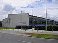
Obereichsfeldhalle

Refurbished prefabricated building

St. Boniface (consecrated in 1993)

City villas in Leinefelde-Süd


_-_August_2009.jpg)

Worbis
Coordinates: 51 ° 25 ' N , 10 ° 22' E
The city of Worbis is mentioned for the first time in a document from 1162. In 1209 a noble family named itself after the place "Worbis". They were probably vassals of the Counts of Lohra . The feudal sovereignty later changed to the Beichlingers and Landgraves of Thuringia . The Count of Beichlingen gave Worbis town charter between 1238 and 1255. The castle was first mentioned in documents in 1289. 1381–1574 the lords of Bülzingslöwen owned the property as a pledge. Later there was no further reference to the castle. The facility stood at the northeast corner of the city and was included in the city fortifications. A ditch still indicates the facility. Even in the Middle Ages, the city had a very favorable traffic situation.
- Worbis

St. Nicholas

Krengeljägerbrunnen

St. Roch Chapel

Registry office


Beuren

Beuren was first mentioned in a legal document in 1128. At that time there was a fortified manor house around which the village was built. Around 1200 a Cistercian monastery was founded in Niederbeuren ("Buren inferior") by Konrad von Bodenstein . It is the oldest monastery of this order on the Eichsfeld. Beuren developed from a market village (1238 "forensi Buren") to a town (1269 "in civitate Buren") through customs and escort income. Urban development began, recognizable by the gates, urban street layout and fortifications. With the relocation of the customs office to Heilbad Heiligenstadt in 1294 , Beuren lost its town charter. From 1870 to 1873 the church “St. Pankratius “built. The "old tower", which was originally built as a customs and residential tower, was rededicated as a church tower when the church was rebuilt. The Beuren monastery existed until 1809; today the buildings still in existence serve as dormitories for people with intellectual disabilities.
Effects

The first documentary mention of Bektiven comes from the year 1191. A church was built around 1516.
Breitenbach

Breitenbach was first mentioned in 1227 in a land exchange with Leinefelde. In 1373, Breitenbach came to the Archdiocese of Mainz through a purchase under Adolf von Nassau. Many residents of Breitenbach were known as traveling salesmen and weavers. A specialty of the village are the slippers known as "booties".
In 1991, Breitenbach was a founding municipality of the administrative community "Am Ohmgebirge" Worbis. In 2004 it was finally incorporated into the newly created twin town of Leinefelde-Worbis.
Width wood
Breitenholz was first mentioned in a document in 1544. Presumably, however, it already existed before and lay desolate for a long time. The name ("broad wood" = extensive forest) comes from a forest area, the remains of which can still be found south of the village in the direction of Bektiven. Breitenholz is an anger village, with a church and anger with a linden tree as the center. The church was built in 1695 and the tower was added later. The altar comes from the Franciscan monastery church in Worbis. Breitenholz has been a place of pilgrimage since 1655 (miraculous image “Maria with the child” from the 15th century).
Towards the end of the Second World War , a V2 launch base was set up in the Birkunger Wald between Bektiven and Breitenholz .
Dog hare

Hundeshagen was first mentioned in a document on April 15, 1282. It is known as the musicians village.
Kallmerode
Kallmerode was first mentioned in a document in 1206. The building material for the towns of Leinefelde and Worbis was extracted from the quarries and gravel pits that were located there.
Kaltohmfeld

The first documentary mention took place in 1418. In the first third of the 16th century, Kaltohmfeld was a desert. A new settlement was started under Anna von Wintzingerode. In 1573 the residents of Kaltohmfeld came under the administration of Mainz, but retained the Protestant faith because of the close ties to the later count families of Wintzingerode. In 1588 a Protestant church ("John the Baptist") was built on the edge of the village, which was torn down in 1655 and rebuilt. Kaltohmfeld later became part of Kirchohmfeld.
Kirchohmfeld


The first documentary mention of Kirchohmfeld (Warmohmfeld, Kirchenohmfelde) comes from the year 1217. Since 1448 Kirchohmfeld was under those of Wintzingerode. The desert place was built from 1515 to 1554 by Hans Wintzingerrode as an independent manor district. Settlement began again around 1539. Heinrich Werner was born here on October 2, 1800 . The fort-like manor complex and the Adelsborn manor house served as a fortification and farm yard until 1945 as the seat of the Wintzingerode gentlemen. After the expropriation in 1945, the complex was torn down to the ground.
By belonging to the domain of those of Wintzingerode, the place became Protestant. There is a Protestant church in the village. The districts of Kaltohmfeld, Adelsborn and Bodenstein belonged to Kirchohmfeld until the municipality merged with the city of Worbis on July 1, 1994.
Wintzingerode

The place Wintzingerode is mentioned for the first time in 1209. The ancestors of the later Counts of Wintzingerode have their residence here. Bodenstein Castle is located above the village . The first mention of a church comes from the year 1389. In the 16th century the place, like their rule, adopted the Protestant faith. Around 1530 Wintzingerode was a desert village. By comparing the farmers from five villages with Hans von Wintzingerode in 1580, a resettlement was favored. In 1633 Heinrich von Wintzingerode set up a free school for the children of the feudal people.
Religions
The lords of Wintzingerode accepted Luther's teachings in the 16th century and adhered to the Protestant religion even after the Counter-Reformation . In accordance with the stipulations in the Augsburg Religious Peace of 1555, this change in religious affiliation was retained on the Eichsfeld even after the Counter Reformation. Because they belong to the domain of those of Wintzingerode, the districts of Kirchohmfeld, Kaltohmfeld and Wintzingerode form a Protestant island in the otherwise Catholic Eichsfeld.
politics
City council
The city council consists of the mayor as chairman and 30 other members, who have been distributed among the individual lists as follows since the local elections on May 26, 2019 :

| Party / list | Seats | G / V |
| CDU | 16 | + 2 |
| FDP | 1 | + 1 |
| FWV | 1 | - 1 |
| The left | 3 | ± 0 |
| SPD | 2 | ± 0 |
| ÖDP / family… 1 | 3 | + 1 |
| AfD | 4th | + 4 |
P / L = gains or losses compared to the 2014 election
The individual mandate holders of the FWV and FDP have joined the CDU parliamentary group.
mayor
In June 2016, Marko Grosa (CDU) was elected as the new mayor in the first ballot. The predecessor in office was Gerd Reinhardt, who had been mayor of Leinefelde since 1990 and mayor of Leinefelde-Worbis since 2004.
coat of arms
In the city council meeting on December 11, 2007, after the approval of the Thuringian administrative office for the city, a new common coat of arms was decided.
Blazon : "In red with silver battlements flanks, a triple-split wave post."
The color combination red-silver of the coat of arms is derived from the Kurmainzer coat of arms. It refers to the former affiliation of the region to the Archdiocese of Mainz and marks the location of the city in Eichsfeld. The city of Leinefelde-Worbis lies in the east with the Wipper in the water catchment area of the Elbe and in the west with the Leine in the water catchment area of the Weser. While the sources of the Leine are in Leinefelde, the Wipper rises in Worbis. The waters are represented by a silver wave pole split in three parts, with the internal drawing graphically resulting in four waves for the sources of the line and the rocker. Furthermore, the coat of arms refers to the castles Bodenstein and Scharfenstein, which are important landmarks for the area of the city, in heraldic implementation. Both Bodenstein Castle and Scharfenstein Castle are symbolized by a pinnacle flank.
The coat of arms was designed by the heraldist Frank Jung.
flag
The city of Leinefelde-Worbis flies a flag. The flag is in red with white flanks (division 1: 2: 1) and bears the city arms.
Coats of arms of the districts

Beuren

Effects

Breitenbach

Dog hare

Kaltohmfeld

Kirchohmfeld

Leinefelde

Worbis

Wintzingerode


Town twinning
After the city merger in 2004, the partnerships have not yet been transferred to the city of Leinefelde-Worbis so far (2007), but continue to exist with the individual city districts.
Leinefelde:
Worbis:
- Medebach in North Rhine-Westphalia , since 1994
- Annœullin in France since 2000
- Mezöcsát in Hungary , since 2000
Beuren:
- Měrunice in the Czech Republic since 2004
Width wood:
Breitenbach:
- Hildfeld in the Hochsauerland since 1989
Attractions

- Old Church (Leinefelde)
- Bodenstein Castle near Kirchohmfeld. Best preserved castle in Eichsfeld (900 years old).
- St. Antonius (Worbis)
- Bear Park Worbis
- Japanese garden
- Scharfenstein Castle
- The German half-timbered road runs through Worbis
- Sculpture group by the sculptor Werner Löwe : The fur trader depicted in Leinefelder Bahnhofstrasse is reminiscent of the earlier fur and casing trade in Eichsfeld. Because of this trade, the Leinefelder were also called "lamb's tails".
Museums
House "Gülden Creutz" , local museum with a shoemaker's workshop in the 1920s.
Buildings
- St. Antonius Monastery Church in Worbis. Laying of the foundation stone on June 13, 1668.
- Town hall "Wasserturm" in Leinefelde: built in 1867 as a water tower of the later Deutsche Reichsbahn , in 1905 heightened with a half-timbered construction (container volume 300 m³), used until 1986 and converted into town hall in 1996/97.
Economy and Infrastructure
Companies
The following companies have their headquarters or a production facility in Leinefelde-Worbis
- mawa cosmetics
- HUWI basketry (supplies florists ), OT Beuren
- Neunspringe Brewery , OT Worbis
- European yarns MRF (manufacturer of half worsted yarns )
traffic


railroad
Leinefelde is the junction between the nationally important Halle – Hann railway line. Münden and the Erfurt - Göttingen line ( Gotha – Leinefelde railway ). The lines RE1 (Göttingen – Leinefelde – Erfurt – Glauchau) and RE2 (Kassel – Leinefelde – Erfurt) of the DB Regio , RE9 (Kassel – Leinefelde – Nordhausen – Halle (Saale)) and RE19 (Leinefelde – Nordhausen – Halle (Saale) stop here )) of Abellio Rail Central Germany and regional railways.
The Halle – Kassel line was expanded to two tracks and electrified until 1994 as a German Unity transport project . To this end, an electronic signal box was set up in Leinefelde station as one of the first in Thuringia, which also controls the Heilbad Heiligenstadt - Gernrode and Leinefelde - Bad Langensalza sections .
From 1897 Leinefelde was the starting point of the Leinefelde – Wulften railway , which connected Leinefelde, Breitenbach, Worbis and Wintzingerode to the Northeim – Nordhausen railway via Duderstadt . Interrupted from 1945 by the inner-German border between Teistungen and Duderstadt, the line was gradually shut down until 2001 and dismantled until 2005.
Autobahn and federal highways
The federal road 247 ( Duderstadt - Mühlhausen ) and the state road 3080 (the former B 80 ) cross in Leinefelde. The federal autobahn 38 ( Halle (Saale) - Göttingen ), also a German unity transport project , has been directly adjacent to the city of Leinefelde since 2006.
Bus transport
Urban and regional bus transport is carried out by the Eichsfeldwerke .
media
The regional daily newspaper for Leinefelde-Worbis is the Thüringer Allgemeine , whose local section ( Eichsfelder Allgemeine ) is produced in Heilbad Heiligenstadt .
There is also the newspaper Litfaßsäule , which appears once a month and is produced in Leinefelde.
Eichsfelder Nachrichten - an online newspaper for the whole of Eichsfeld (including the Lower Saxony part and Eichsfeld villages in the Unstrut-Hainich district), editorial office in Leinefelde.
The regional TV broadcaster Offener Kanal Eichsfeld (OKE) was based in Leinefelde . It was closed on December 31, 2009 by the Thuringian State Media Authority for financial reasons.
Public facilities
- Tax office in Worbis (until October 2006)
- Land registry office in Worbis
- Agricultural Office in Leinefelde
- Nordhausen employment agency, Leinefelde office
- North Thuringia Road Construction Office in Leinefelde
- German Red Cross District Association Eichsfeld e. V.
- Caritas regional office Eichsfeld / Unstrut-Hainich in Leinefelde
- Diakonisches Werk Eichsfeld-Mühlhausen e. V. in Leinefelde
education
The following schools exist in Leinefelde-Worbis:
- State high school "Marie Curie" in Worbis
- Elementary and regular school "Johann Carl Fuhlrott" in Leinefelde
- Elementary and regular school "Konrad Hentrich" in Leinefelde
- Primary school "Am Ohmgebirge" in Worbis
- Worbis regular school
- Free integrative comprehensive school "Kleeblatt" in Beuren
- Special school in Leinefelde
- Gottfried Wilhelm Leibniz Gymnasium in Leinefelde
- State vocational school of the Eichsfeld in Leinefelde
- Eichsfeld Music School
Personalities

- Heinrich Werner (1800–1833), composer of the " Heidenröslein "
- Johann Carl Fuhlrott (1803–1877), discoverer of the Neanderthal man
- Bernard Quaritch (1819–1899), English bookseller and collector
- Levin von Wintzingeroda-Knorr (1830–1902), politician, landowner, member of the Prussian manor house
- Konrad Hentrich (1880–1972), linguist
- Herman Joseph Meysing OMI (1886–1963), Archbishop of Bloemfontein in South Africa
- Karl Kaufhold (1922–2015), composer, conductor and organist
- Georg Schaefer (1926–1990), German-American painter and book author
- Hans-Reinhard Koch (1929–2018), first auxiliary bishop of the Erfurt diocese, which was newly founded in 1994
- Horst-Jürgen Fuhlrott (* 1935), politician (NPD)
- Barbara Saß-Viehweger (* 1943), politician, lawyer and notary (CDU)
- Gerhard Rupprath (* 1945), pediatrician and chief physician
- Michael Robert Rhein (* 1964), singer and founder of the medieval rock band In Extremo
- Stephan Kulle (* 1967), journalist and television presenter
- Johannes Krause (* 1980), biochemist, professor at the Eberhard Karls University of Tübingen
- Marco Hartmann (* 1988), soccer player
- Sebastian Huke (* 1989), soccer player
- Stefan Bötticher (* 1992), track cyclist
literature
- Ulrich Hussong: Seal and coat of arms of the cities of Leinefelde and Leinefelde-Worbis. In: Eichsfeld-Jahrbuch 22 (2014), pp. 337–344
Web links
- leinfeld-worbis.de - official website
Individual evidence
- ^ Population of the municipalities from the Thuringian State Office for Statistics ( help on this ).
- ^ StBA: Changes in the municipalities in Germany, see 2004
- ↑ a b Federal Statistical Office (ed.): Municipalities 1994 and their changes since January 1, 1948 in the new federal states. Metzler-Poeschel publishing house, Stuttgart 1995, ISBN 3-8246-0321-7 .
- ↑ StBA: Changes in the municipalities of Germany, see 1995
- ^ StBA: Changes in the municipalities in Germany, see 2000
- ↑ Thuringian Law and Ordinance Gazette No. 7 2018 of July 5, 2018 , accessed on July 6, 2018
- ^ Peter Richter : Case study Leinefelde. In: The prefabricated building as a crisis area . Dissertation, Hamburg 2006, pp. 124–186. ( Online ; PDF; 676 kB)
- ^ Th. Bienert: Medieval castles in Thuringia. Wartberg Verlag, 2000, ISBN 3-86134-631-1 , p. 47.
- ↑ Worbis Castle
- ↑ Thuringian Association of the Persecuted of the Nazi Regime - Association of Antifascists and Study Group of German Resistance 1933–1945 (Ed.): Local history guide to sites of resistance and persecution 1933–1945. Series: Heimatgeschichtliche Wegweiser Volume 8 Thuringia, Erfurt 2003, ISBN 3-88864-343-0 , p. 40.
- ^ Th. Bienert: Medieval castles in Thuringia. Wartberg Verlag, 2000, ISBN 3-86134-631-1 , p. 47.
- ↑ Castle
- ↑ [1]
- ↑ http://www.thueringer-allgemeine.de/web/zgt/politik/detail/-/specific/Marko-Grosa-CDU-ist-neuer-Buergermeister-von-Leinefelde-Worbis-2091087222
- ↑ :: Eichsfeld News :: . In: :: Eichsfelder Nachrichten :: . ( eichsfelder-nachrichten.de [accessed October 10, 2017]).
Beinrode | Beuren | Effects | Breitenbach | Width wood | Dog rabbit | Kallmerode | Kaltohmfeld | Kirchohmfeld | Leinefelde | Wintzingerode | Worbis
At the Ohmberg | Arenshausen | Asbach-Sickenberg | Berlingerode | Birkenfelde | Bodenrode-Westhausen | Bornhagen | Brehme | Width worbis | Buhla | Burgwalde | Büttstedt | Dieterode | Dietzenrode / Vatterode | Dingelstädt | Ecklingerode | Effelder | Eichstruth | Ferna | Freienhagen | Fretterode | Geisleden | Geismar | Gerbershausen | Gernrode | Glasehausen | Großbartloff | Haynrode | Heilbad Heiligenstadt | Heuthen | Hohengandern | High cross | Kella | Kirchgandern | Kirchworbis | Krombach | Küllstedt | Leinefelde-Worbis | Lenterode | Lindewerra | Lutter | Mackenrode | Marth | Lower Orschel | Pfaffschwende | Reinholterode | Rohrberg | Röhrig | Rustenfelde | Schachtebich | Schimberg | Schönhagen | Schwobfeld | Sickerode | Sunstone | Steinbach | Steinheuterode | Keyings | Services | Thalwend | Uder | Volkerode | Waxed | Wahlhausen | Blowing | Wiesenfeld | Wingerode | Wüstheuterode