Hohengandern
| coat of arms | Germany map | |
|---|---|---|

|
Coordinates: 51 ° 22 ′ N , 9 ° 57 ′ E |
|
| Basic data | ||
| State : | Thuringia | |
| County : | Eichsfeld | |
| Management Community : | Hanstein-Rusteberg | |
| Height : | 218 m above sea level NHN | |
| Area : | 6.84 km 2 | |
| Residents: | 591 (Dec. 31, 2019) | |
| Population density : | 86 inhabitants per km 2 | |
| Postal code : | 37318 | |
| Area code : | 036081 | |
| License plate : | EIC, HIG, WBS | |
| Community key : | 16 0 61 048 | |
| Association administration address: | Steingraben 49 37318 Hohengandern |
|
| Website : | ||
| Mayor : | Michael Trümper | |
| Location of the community of Hohengandern in the Eichsfeld district | ||
Hohengandern is a municipality in the Eichsfeld district in Thuringia . It is part and seat of the Hanstein-Rusteberg administrative association .
Geographical location
Hohengandern is located about 1.2 km east of the border triangle Hesse-Lower Saxony-Thuringia , directly west of the small Leine tributary Mühlbach . The village extends northeast of up to 325 m above sea level. NN high elevation of the old wood and the 375 m above sea level. NN high Neuseesen-Werleshäuser heights at about 210 to 225 m height. The highest point in the area is the 369 m high Heuberg in the southeast.
To the north are Niedergandern and Besenhausen (in Lower Saxony ), to the northeast is Kirchgandern , to the east of Arenshausen , to the southeast of Unterstein , to the south of Bornhagen (all in Thuringia), to the south-south-west of Neuseesen , to the south-west of Arnstein Castle , to the west of the Eichenberg railway station and to the north-west of Hebenshausen (all in Hesse ). Through the village leads the section Arnstein Arenshausen lock the federal highway 80 and the section Arenshausen-Eichenberg the railway line Halle-Hann. Münden .
history
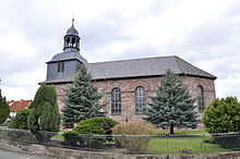
Hohengandern was first mentioned in 1376 as Hohngandern . A first mention in 1127 can also refer to the neighboring Gandern villages. The place was part of Kurmainz until secularization and from 1802 to 1945 part of the Prussian province of Saxony . In 1856 the village church Hohengandern was built on an older previous church (1597).
From 1945 Hohengandern was part of the Soviet occupation zone and from 1949 part of the GDR . From 1961 until the turnaround and reunification in 1989/1990, the place was near the inner-German border . On November 12, 1989, a crossing between Hohengandern and Neu-Eichenberg in Hesse was opened. Hohengandern has been part of the newly established state of Thuringia since 1990.
The square quarry stone building of the church tower with a slate hood is a building from the past. The unplastered ashlar structure of the ship was built in late Classicist form in 1856. Large arched windows provide daylight to the room.
Population development
Development of the population (December 31) :
|
|
|
|
|
- Data source: Thuringian State Office for Statistics
politics
Municipal council
The Hohengandern municipal council consists of eight members.
(Status: 2014 local elections)
mayor
Mayor Bernd Ziegenbein was re-elected on April 22, 2012.
coat of arms
Blazon : "red-green-silver-green silver-green six times gest changes with a central red slices , top in red is a growing, auffliegender, silver Ganter, front and rear of silver per an inclined slumped, green oak leaf and down in green three ( 1: 2) silver, waxing moons . "
Explanation of the coat of arms: The flying (swing opening) Ganter (Gänserich) in the shield head represents a talking coat of arms for Hohengandern, the oak leaves stand for the Eichsfeld, and the three crescent moon refer to the former rule of those von Hanstein , to which Hohengandern belonged.
Sons and daughters of the church
- Karl Drößler (* 1937), German animal physiologist and soccer player
- Gerhard Zickenrott (* 1939), former German trade unionist (FDGB) and politician (SED)
literature
- 100 years of the Hohengandern fire brigade . Friedland 1996, p. 30, format A5 .
Web links
- Hohengandern on the website of the Hanstein-Rusteberg administrative association
Individual evidence
- ^ Population of the municipalities from the Thuringian State Office for Statistics ( help on this ).
- ↑ Erhard Müller: The place names of the district of Heiligenstadt. Heilbad Heiligenstadt 1989, p. 18
- ^ Werner Hermann: Village churches in Thuringia. Verlagshaus Thuringia, 1992, ISBN 3-86087-014-9 , p. 51.
- ↑ 2014 municipal council elections in Thuringia - final result. Thuringian State Office for Statistics, accessed on May 25, 2017 .
- ↑ Mayoral elections in Thuringia. The regional returning officer, archived from the original on December 16, 2013 ; Retrieved May 25, 2017 .


