
Dietzenrode / Vatterode
| coat of arms | Germany map | |
|---|---|---|

|
Coordinates: 51 ° 18 ' N , 10 ° 2' E |
|
| Basic data | ||
| State : | Thuringia | |
| County : | Eichsfeld | |
| Management Community : | Uder | |
| Height : | 230 m above sea level NHN | |
| Area : | 5.78 km 2 | |
| Residents: | 125 (Dec. 31, 2019) | |
| Population density : | 22 inhabitants per km 2 | |
| Postal code : | 37318 | |
| Area code : | 036087 | |
| License plate : | EIC, HIG, WBS | |
| Community key : | 16 0 61 024 | |
| Association administration address: | Settlement 14 37318 Uder |
|
| Website : | ||
| Mayor : | Walter Homburg | |
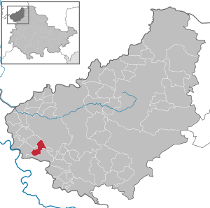
| Location of the Dietzenrode / Vatterode community in the Eichsfeld district | ||
  |
||

Dietzenrode / Vatterode is a municipality in the Uder administrative community in the Thuringian district of Eichsfeld .
Geographical location
Dietzenrode / Vatterode is about ten kilometers southwest of the district town of Heilbad Heiligenstadt in the Eichsfeld-Hainich-Werratal nature park . By fins are its districts (bach down looking) Vatterode and Dietzenrode located between the mountain ranges Höhenberg ( 508.9 m above sea level. NN ) in the northwest and Gobert ( 569 m above sea level. NN extend to the south and southeast), from the eastern Werra influx Walse .
Community structure
The districts Dietzenrode and Vatterode belong to the municipality of Dietzenrode / Vatterode.
history
Dietzenrode district
The first mention as Tuzenrode "(The village built on the clearing of the Dizo ... ( nick form of Ditrich))" falls in the year 1256. Dietzenrode was first mentioned in 1288.
Vatterode district
The place was first mentioned in a document in 1331. It was originally a monastery, in 1888 a new church was built on the site of the old monastery church.
On April 8, 1945, Vatterode was shelled by American artillery. Four residents were killed. On April 9, it was occupied without a fight.
The previously Hessian village of Vatterode was incorporated into the Soviet occupation zone and thus to Thuringia in 1945 as part of border corrections due to the Wanfrieder Agreement (see also: Schifflersgrund ).
Dietzenrode / Vatterode
On July 1, 1950, Vatterode was incorporated into Dietzenrode. This community came to Wüstheuterode on March 15, 1974 . On June 1, 1990, Dietzenrode and Vatterode were spun off from Wüstheuterode. They now formed the new Dietzenrode / Vatterode community.
Population development
Development of the population (December 31) :
|
|
|
|
|
- Data source: Thuringian State Office for Statistics
politics
Municipal council
The Dietzenrode / Vatterode council consists of six council members.
- Individuals: 6 seats
(As of: local elections on May 25, 2014)
mayor
The honorary mayor Walter Homburg was re-elected in a runoff election on June 19, 2016.
coat of arms
Blazon : "In green, divided by a gold bar, on top a rising silver horse growing out of the bar, below a silver table over a three-leaved silver linden branch."
The municipal coat of arms contains heraldry elements for each, once independent district. Dietzenrode had a horse as a symbol in the municipal seal until 1953 and from 1990. Vatterode is symbolized by the table with a linden branch, both of which point to the old village green with angled table and linden tree. The coat of arms was designed by Karl-Heinz Fritze.
literature
- Karl Heinz Vatterott: Vatterode - A name in the history of the Eichsfeld and the Mansfelder Land. Mecke, Duderstadt 2008, ISBN 978-3-936617-95-5 .
Individual evidence
- ^ Population of the municipalities from the Thuringian State Office for Statistics ( help on this ).
- ↑ Local elections in Thuringia on May 25, 2014. Elections of the community and city council members. Preliminary results. (PDF) The State Returning Officer, accessed on May 23, 2017 .
- ↑ Mayoral elections in Thuringia. Thuringian State Office for Statistics, accessed on May 23, 2017 .
Web links
At the Ohmberg | Arenshausen | Asbach-Sickenberg | Berlingerode | Birkenfelde | Bodenrode-Westhausen | Bornhagen | Brehme | Width worbis | Buhla | Burgwalde | Büttstedt | Dieterode | Dietzenrode / Vatterode | Dingelstädt | Ecklingerode | Effelder | Eichstruth | Ferna | Freienhagen | Fretterode | Geisleden | Geismar | Gerbershausen | Gernrode | Glasehausen | Großbartloff | Haynrode | Heilbad Heiligenstadt | Heuthen | Hohengandern | High cross | Kella | Kirchgandern | Kirchworbis | Krombach | Küllstedt | Leinefelde-Worbis | Lenterode | Lindewerra | Lutter | Mackenrode | Marth | Lower Orschel | Pfaffschwende | Reinholterode | Rohrberg | Röhrig | Rustenfelde | Schachtebich | Schimberg | Schönhagen | Schwobfeld | Sickerode | Sunstone | Steinbach | Steinheuterode | Keyings | Services | Thalwend | Uder | Volkerode | Waxed | Wahlhausen | Blowing | Wiesenfeld | Wingerode | Wüstheuterode