
At the Ohmberg
| coat of arms | Germany map | |
|---|---|---|

|
Coordinates: 51 ° 29 ′ N , 10 ° 28 ′ E |
|
| Basic data | ||
| State : | Thuringia | |
| County : | Eichsfeld | |
| Height : | 290 m above sea level NHN | |
| Area : | 31.57 km 2 | |
| Residents: | 3621 (Dec. 31, 2019) | |
| Population density : | 115 inhabitants per km 2 | |
| Postal code : | 37345 | |
| Area code : | 036077 | |
| License plate : | EIC, HIG, WBS | |
| Community key : | 16 0 61 116 | |
| Community structure: | 3 districts , 4 settlements | |
| Address of the municipal administration: |
Fleckenstrasse 49 37345 Am Ohmberg |
|
| Website : | ||
| Mayor : | Heiko Steinecke ( CDU ) | |
| Location of the community Am Ohmberg in the Eichsfeld district | ||
  |
||

The community Am Ohmberg is a rural community in the Eichsfeld district ( Thuringia ). The seat of the rural community is both in the district of Bischofferode and in the district of Großbodungen.
geography
- Structure of the rural community

Districts (former communities) are Bischofferode with Hauröden and Thomas-Müntzer-Siedlung , Großbodungen with Wallrode and Neustadt with Neubleicherode .
history
On December 1, 2010, the rural community was formed from the voluntary amalgamation of the communities of Bischofferode with Hauröden , Großbodungen with Wallrode and Neustadt with Neubleicherode . The community belonged to the Eichsfeld-Südharz administrative community until its dissolution on December 1, 2011 . Bischofferode is the largest part of the community Am Ohmberg and it was a center of potash mining until 1990 .
Population development
Development of the population (May 9, 2011 - census database).
From the reporting year 2012, the basis for updating the population is the data from the 2011 census with the reference date May 9, 2011.
| year | 2010 | 2011 | 2012 | 2013 | 2014 | 2015 | 2016 | 2017 | 2018 | 2019 |
|---|---|---|---|---|---|---|---|---|---|---|
| Residents | 3,973 | 3,851 | 3,809 | 3,775 | 3,753 | 3,803 | 3,785 | 3,681 | 3,641 | 3,621 |
- Data source: Thuringian State Office for Statistics
politics
Municipal council
The local elections on May 26, 2019 led to the following result with a turnout of 60.3% (2014: 54.6%):
| Party / list | Share of votes | Seats |
| Citizens for Citizens | 52.7% | 9 |
| CDU | 43.8% | 7th |
| NPD | 3.5% | 0 |
coat of arms
Blazon : “Lowered wave division of silver and blue above the golden arched base; below covered with a silver ploughshare; from it a green leafed linden tree. "
“The symbols of the formerly independent localities have been incorporated into the coat of arms of the newly created political community. The linden tree was borrowed from the coat of arms of the Neustadt community, a ploughshare from the 'talking' coat of arms of Bischofferode, which stands for the clearing activities of the first settlers of the place, which gave the name. For the community of Großbodungen, a blue wave division of the shield was chosen as a symbol for the brook Bode, which flows through the communities Bischofferode and Großbodungen before it flows into the Wipper at Bleicherode. The curved base of the shield finally points to the name of the newly created municipality of Ohmberg . "

Bischofferode, view from the Hühnerberg
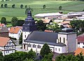
Church of the "Birth of Mary" Bischofferode
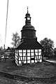
Trinity Church Hauröden

St Simon and Jude Thaddäus Neustadt

The Bode in Bischofferode towards Holungen
Angerlinde, about 375 years old landmark of Neustadt


Web links
Individual evidence
- ^ Population of the municipalities from the Thuringian State Office for Statistics ( help on this ).
- ↑ StBA: Area changes from January 01 to December 31, 2010
- ^ Thuringian State Office for Statistics
- ^ Thuringian State Office for Statistics: Municipal council election 2019 in Thuringia - Am Ohmberg
- ↑ Alexander Jacob's coat of arms
At the Ohmberg | Arenshausen | Asbach-Sickenberg | Berlingerode | Birkenfelde | Bodenrode-Westhausen | Bornhagen | Brehme | Width worbis | Buhla | Burgwalde | Büttstedt | Dieterode | Dietzenrode / Vatterode | Dingelstädt | Ecklingerode | Effelder | Eichstruth | Ferna | Freienhagen | Fretterode | Geisleden | Geismar | Gerbershausen | Gernrode | Glasehausen | Großbartloff | Haynrode | Heilbad Heiligenstadt | Heuthen | Hohengandern | High cross | Kella | Kirchgandern | Kirchworbis | Krombach | Küllstedt | Leinefelde-Worbis | Lenterode | Lindewerra | Lutter | Mackenrode | Marth | Lower Orschel | Pfaffschwende | Reinholterode | Rohrberg | Röhrig | Rustenfelde | Schachtebich | Schimberg | Schönhagen | Schwobfeld | Sickerode | Sunstone | Steinbach | Steinheuterode | Keyings | Services | Thalwend | Uder | Volkerode | Waxed | Wahlhausen | Blowing | Wiesenfeld | Wingerode | Wüstheuterode
Bischofferode with Hauröden and Thomas-Müntzer-Siedlung | Large floors with Wallrode | Neustadt with Neubleicherode