
Bornhagen
| coat of arms | Germany map | |
|---|---|---|

|
Coordinates: 51 ° 21 ' N , 9 ° 57' E |
|
| Basic data | ||
| State : | Thuringia | |
| County : | Eichsfeld | |
| Management Community : | Hanstein-Rusteberg | |
| Height : | 300 m above sea level NHN | |
| Area : | 6.57 km 2 | |
| Residents: | 341 (Dec. 31, 2019) | |
| Population density : | 52 inhabitants per km 2 | |
| Postal code : | 37318 | |
| Area code : | 036081 | |
| License plate : | EIC, HIG, WBS | |
| Community key : | 16 0 61 014 | |
| LOCODE : | DE 89B | |
| Association administration address: | Steingraben 49 37318 Hohengandern |
|
| Website : | ||
| Mayor : | Mario-Paul Apel | |
| Location of the Bornhagen community in the Eichsfeld district | ||
  |
||

Bornhagen is a municipality in the Eichsfeld district of Thuringia at the foot of the Hanstein castle ruins . The community belongs to the Hanstein-Rusteberg administrative community .
location

Bornhagen is located on the western edge of the Eichsfeld near the border triangle Thuringia - Hesse - Lower Saxony south of the federal highway 80 . The place is located on the north-northeast slope below Hanstein Castle at an altitude of 285 to 330 m above sea level. NN .
The Rimbach district is located immediately south of the castle ruins at an altitude of 370 m. Neighboring places are Neuseesen in the west, Hohengandern and Arenshausen in the north and Gerbershausen in the east. The highest elevation in the local area is the Junkerkuppe (510.7 m) in the ridge of the Höhebeng .
history
Hagen , mentioned in 1291, is probably today's Bornhagen, when a Count von Everstein enfeoffed Hugo von der Mark and Konrad von Rusteberg with property in Hagen, Wahlhausen and Eichenberg. Bornhagen was mentioned in writing for the first time in the period from 1352 to 1360 and again in 1364 as Bornhain and was an outbuilding of Hanstein Castle. The history of the village is shaped by the neighboring Hanstein Castle: At the beginning of the 16th century, the family branches of the Lords of Hanstein moved into seven newly built knightly seats in Bornhagen (Bornhof, Junkerhof, two Koburger Höfe, Ratshof, Steinscher Hof and Unterhof). After extensive destruction in the Thirty Years War , the farms were rebuilt.
From 1816 the place belonged to the administrative district of Erfurt in the Prussian province of Saxony . At the beginning of the 20th century, 90 people lived in Bornhagen. On April 1, 1936, the much larger town of Rimbach was incorporated into the Bornhagen community.
In 1945 a bomb fell between the church and the castle wall. In the house on the castle wall, which was later demolished, there were mechanical calculating machines from the ISCO designer. The village was occupied by US soldiers without a fight.
Since Bornhagen was too close to the zone border for the SED , many citizens were forcibly resettled during the GDR era.
On November 22nd 2017, the Center for Political Beauty unveiled the Holocaust memorial in front of Höcke's house under the project name Bau! 24 concrete steles in the style of the Holocaust memorial in Berlin on the rented neighboring property of AfD politician Björn Höcke in the village and attracted nationwide attention. In a speech in Dresden in January 2017, the politician called for "a 180 degree change in the politics of memory" and said: "We Germans, that is, our people, are the only people in the world that have a" monument of shame "in their hearts Has planted the capital. "
Population development
Development of the population (December 31) :

|
|
|
|
|
- Data source: Thuringian State Office for Statistics
politics
Municipal council
The Bornhagen municipal council is composed of six council members.
- Interest group / fire brigade: six seats
(As of: local elections on May 25, 2014)
mayor
The honorary mayor Mario-Paul Apel was elected on June 6, 2010 and re-elected in 2016.
State election 2014
In Bornhagen, the AfD achieved its record result in a comparison of all municipalities in the Thuringian state elections in 2014 . It achieved 36.5 percent of the 115 valid second votes and was the strongest party ahead of the CDU (29.6%) and the Left (16.5%). The Thuringian top candidate Björn Höcke , who lives in Bornhagen , achieved 38.3 percent - 44 of 115 valid first votes.
Attractions
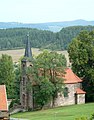
- The Hanstein castle ruins near Bornhagen probably go back to the period from 820 to 850, but they can be reliably documented from 1070.
- The Catholic church in the Rimbach district was built before 1400. The double tower dates from 1921, the late Gothic winged altar in the church from 1407.
- The Protestant church was built in 1877. A large image of Jesus in the Nazarene style is the eye-catcher in the chancel .
- The sausage museum to present the Eichsfeld slaughtering traditions.
- Replica of the Berlin Holocaust memorial

View of Hanstein Castle

Catholic church in the district of Rimbach
Evangelical Church in Bornhagen

Sausage Museum
Replica of the Berlin Holocaust memorial


Personalities
Born in Bornhagen
- Conrad von Hanstein (around 1500–1553), imperial officer, with a splendid grave monument in the Katharinenkirche Oppenheim
- Arnold Albrecht (* 1950), holder of the Federal Cross of Merit and Order of Merit of the Free State of Thuringia
Associated with Bornhagen
- Björn Höcke (* 1972), German politician ( AfD ) and former high school teacher, lives in Bornhagen
Web links
- Bornhagen municipality on the side of the Hanstein-Rusteberg administrative association
Individual evidence
- ^ Population of the municipalities from the Thuringian State Office for Statistics ( help on this ).
- ↑ Ed. Ulrich Harteisen, Ansgar Hoppe et al .: Das Eichsfeld. Volume 79 of the series Landscapes in Germany. Verlag Böhlau , Vienna / Cologne / Weimar 2018, p. 271
- ↑ Erhard Müller: The place names of the district of Heiligenstadt. Heilbad Heiligenstadt 1989, p. 12
- ^ A b Walter Rassow: Descriptive representation of the older architectural and art monuments of the district of Heiligenstadt . Ed .: Historical Commission for the Province of Saxony and the Duchy of Anhalt. Otto Hendel, Halle ad p. 1909, Rusteberg (old and new castle), p. 32-33 .
- ^ Michael Rademacher: German administrative history from the unification of the empire in 1871 to the reunification in 1990. District of Heiligenstadt. (Online material for the dissertation, Osnabrück 2006).
- ↑ Arno Frank: Action by the Center for Political Beauty: A Holocaust Memorial - at Björn Höcke's front door . In: Spiegel Online . November 22, 2017 ( spiegel.de [accessed November 22, 2017]).
- ↑ Höcke should get on his knees. Is that art? In: welt.de , November 22, 2017.
- ^ Artists erect a Holocaust memorial in front of Björn Höcke's front door . In: nzz.ch , November 22, 2017.
- ↑ "Monument of Shame" on the doorstep of Höcke . In: tagesspiegel.de , November 22, 2017.
- ^ 2014 municipal council elections in Thuringia - final result: Bornhagen. Retrieved June 6, 2017 .
- ↑ Local elections in Thuringia on June 6, 2010. Elections for community and city council members. Preliminary results. The regional returning officer, accessed on June 6, 2010 .
- ↑ [1]
At the Ohmberg | Arenshausen | Asbach-Sickenberg | Berlingerode | Birkenfelde | Bodenrode-Westhausen | Bornhagen | Brehme | Width worbis | Buhla | Burgwalde | Büttstedt | Dieterode | Dietzenrode / Vatterode | Dingelstädt | Ecklingerode | Effelder | Eichstruth | Ferna | Freienhagen | Fretterode | Geisleden | Geismar | Gerbershausen | Gernrode | Glasehausen | Großbartloff | Haynrode | Heilbad Heiligenstadt | Heuthen | Hohengandern | High cross | Kella | Kirchgandern | Kirchworbis | Krombach | Küllstedt | Leinefelde-Worbis | Lenterode | Lindewerra | Lutter | Mackenrode | Marth | Lower Orschel | Pfaffschwende | Reinholterode | Rohrberg | Röhrig | Rustenfelde | Schachtebich | Schimberg | Schönhagen | Schwobfeld | Sickerode | Sunstone | Steinbach | Steinheuterode | Keyings | Services | Thalwend | Uder | Volkerode | Waxed | Wahlhausen | Blowing | Wiesenfeld | Wingerode | Wüstheuterode