Berlingerode
| coat of arms | Germany map | |
|---|---|---|

|
Coordinates: 51 ° 27 ' N , 10 ° 14' E |
|
| Basic data | ||
| State : | Thuringia | |
| County : | Eichsfeld | |
| Management Community : | Lindenberg / Eichsfeld | |
| Height : | 226 m above sea level NHN | |
| Area : | 11.74 km 2 | |
| Residents: | 1222 (Dec. 31, 2019) | |
| Population density : | 104 inhabitants per km 2 | |
| Postal code : | 37339 | |
| Area code : | 036071 | |
| License plate : | EIC, HIG, WBS | |
| Community key : | 16 0 61 003 | |
| LOCODE : | DE BGV | |
| Association administration address: | Main street 17 37339 Teistungen |
|
| Website : | ||
| Mayor : | Daniel Bertram ( CDU ) | |
| Location of the municipality of Berlingerode in the Eichsfeld district | ||
Berlingerode is a municipality in the Eichsfeld district in Thuringia . It belongs to the administrative community Lindenberg / Eichsfeld .
Geographical location
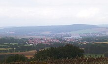
Berlingerode is located about 11 kilometers northeast of Heilbad Heiligenstadt and five kilometers southwest of Duderstadt in Unter Eichsfeld . The district lies on the southern edge of the Eichsfeld basin and at the foot of the steep slope of the Zehnsberg . The location is framed by the Hungerberg (349 m) in the west, the Rotenberg (407 m) in the southwest, the Bodenberg (397 m) in the south and the Eichberg (316 m) in the east. The Finkgraben , a tributary of the Eichbach , flows through the village and flows into the Hahle in Teistungen .
Neighboring places of Berlingerode are Teistungen in the northeast, Hundeshagen in the southeast, Reinholterode in the southwest, Neuendorf in the west and Bleckenrode in the northwest. The place is opened up by the state roads L 1009 and L 2015 . Not far to the north ran the former inner German border and today's border between Thuringia and Lower Saxony .
history
Berlingerode was first mentioned in a document on December 5, 1266. The old castle or castle Westernhagen was located on a mountain spur in its area . It was completely destroyed and demolished in the Peasants' War. Berlingerode belonged to Kurmainz until the secularization in 1802 . From 1802 to 1807 the place became Prussian and then became part of the Kingdom of Westphalia . From 1815 he was part of the Prussian province of Saxony (Worbis district). According to a statistical study, the village of Berlingerode had 888 Catholic and 54 Protestant inhabitants around 1840. The patronage of the village was exercised by the von Westernhagen aristocratic family as landlords, feudal lords and court lords. 161 houses, 93 stables and barns, two jugs and three taverns were noted. School was attended by 140 school-age boys and 119 girls. At that time, there was little artisanal linen weaving and textile production in the village, only two linen looms and six looms for other fabrics were recorded. The overview lists a wagner, four tailors, seven shoemakers, a broom-maker, four whitewashers, three blacksmiths, two butchers, 17 servants and 18 maids as other commercial and handicraft businesses. There was a grinder, the oak mill . Five grocers (victuals) and three innkeepers looked after the residents. The livestock consisted of 61 horses, 115 cattle, 575 sheep, 61 goats and 51 pigs. The village corridor comprised 3244 acres , of which 2246 acres were arable land, 47 acres of garden land, 50 acres of meadows and 30 acres of pasture as arable land. Furthermore, 456 acres of private forest and 413 acres of fallow land were named. The yield from poultry and beekeeping was just as significant. The Eichholzmühle was damaged several times by fires in the 19th century. The location was unfavorable, so the miller's family had to cease operations as early as 1900. The buildings were in poor structural condition and were torn down, the square has been a fruit tree and agricultural area ever since. To finance the construction of the Sanct-Stephanus-Kirche from 1896 to 1898, the protective coat Madonna altar from 1685 was sold.
Berlingerode was occupied by the US Army on April 9, 1945 . This was preceded by artillery bombardment with two civilian dead, damage to the church and numerous residential buildings.
From July 1945 to 1949 the place belonged to the Soviet occupation zone SBZ and from 1949 became part of the GDR . From 1961 until the turnaround and reunification in 1989/1990, Berlingerode was affected by the closure of the nearby inner-German border. Since 1990 the place belongs to the re-established state of Thuringia. The newly built village community center was opened in 1996.
Population development
Development of the population (December 31) :
|
|
|
|
|

- Data source: Thuringian State Office for Statistics
politics
Municipal council
The town council of Berlingerode consists of 12 council members.
- CDU : 8 seats
- Citizens for Berlingerode: 4 seats
(As of: local elections on May 25, 2014)
mayor
The honorary mayor Dr. Daniel Bertram (CDU) was elected on June 5, 2016. The first deputy is Jürgen Huppert (CDU).
Worth seeing
- the Catholic St. Stephen Church
- the home parlor
- the ground monument of the former Westernhagen Castle
Individual evidence
- ^ Population of the municipalities from the Thuringian State Office for Statistics ( help on this ).
- ↑ Otto Dorbencker (arrangement and ed.): Regesta diplomatica necnon epistolaria historiae Thuringiae (1128 1266) . tape 3 . Fischer, Jena 1925. No. 3512
- ↑ Carl August Nobrack: detailed geographic-statistical-topographical description of the district of Erfurt . Erfurt 1841, p. 196-197 .
- ↑ Volker Große, Klaus Herzberg: "Eichholzmühle Berlingerode" . In: Maik Pinkert (Ed.): Mühlen im Obereichsfeld. A compendium . Eichsfeld-Verlag, Heiligenstadt 2008, ISBN 978-3-935782-13-5 , p. 23-24 .
- ^ Eduard Fritze: The last days of the war in Eichsfeld . Rockstuhl Verlag, Bad Langensalza 2002. ISBN 3-936030-06-5 . P. 185
- ↑ Local elections in Thuringia on June 7th, 2009. Elections for community and city council members. Preliminary results. (PDF; 1.9 MB) The State Returning Officer, accessed on March 8, 2010 .
- ↑ Local elections in Thuringia on June 6, 2010. Elections for community and city council members. Preliminary results. The regional returning officer, accessed on June 6, 2010 .


