
Birkenfelde
| coat of arms | Germany map | |
|---|---|---|

|
Coordinates: 51 ° 21 ' N , 10 ° 1' E |
|
| Basic data | ||
| State : | Thuringia | |
| County : | Eichsfeld | |
| Management Community : | Uder | |
| Height : | 285 m above sea level NHN | |
| Area : | 8.39 km 2 | |
| Residents: | 545 (Dec. 31, 2019) | |
| Population density : | 65 inhabitants per km 2 | |
| Postal code : | 37318 | |
| Area code : | 036083 | |
| License plate : | EIC, HIG, WBS | |
| Community key : | 16 0 61 007 | |
| Association administration address: | Settlement 14 37318 Uder |
|
| Website : | ||
| Mayor : | Adrian Grieß ( CDU ) | |
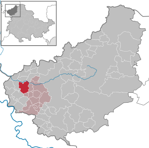
| Location of the municipality of Birkenfelde in the Eichsfeld district | ||
  |
||


Birkenfelde is a municipality in the Uder administrative community in the Thuringian district of Eichsfeld .
geography
Birkenfelde is located in a valley formed by the Iberg in the east, the Heiligenberg in the southwest and the Hennefeste in the west. The valley is also known as the Birkenbach valley because of the birch stream that rises on the Hennefeste.
As a typical clustered village , the houses are arranged around the church standing in the center on a sandstone rock. The townscape is characterized by simple half-timbered houses on high plinths made of roughly hewn sandstone blocks.
The former Rumerode estate, located about one kilometer to the northwest, belongs to the location of Birkenfelde .
history
Birkenfelde was first mentioned in 1055 in a document from Archbishop Luitpold I of Mainz . In this reference point, among other things, six Hufen of land are bequeathed to St. Peter's Monastery in Nörten . Hertwig and Siegfried de Birkenfeld were mentioned as witnesses in 1209. In 1313 the monastery Norten handed the family von Hanstein the jurisdiction of a village half, the other half belonged to Mainz as a fief to the above, named after the village of knights of Berchinefeld and later the Lords of Linsingen .
The place Birkenfelde belonged to Kurmainz until the secularization in 1802 . From 1802 to 1807 the place became Prussian and then became part of the Kingdom of Westphalia . From 1815 he was part of the Prussian province of Saxony . In 1909 a branch of the cigar industry was established on site.
From 1945 to 1949 the place belonged to the Soviet occupation zone and from 1949 became part of the GDR . From 1961 until the turnaround and reunification in 1989/1990, Birkenfelde was affected by the closure of the nearby inner-German border. Since 1990 the place belongs to the re-established state of Thuringia.
Of the formerly two manors that existed in Birkenfelde, only the Karlshof still exists (today a retirement and nursing home), the Steinerhof was demolished after the expropriation as part of the land reform in 1948.
On February 21, 1996, the Christian Scouting Association of Germany bought a listed four-sided courtyard in Mitteldorf as the federal center.
Population development

Development of the population (December 31) :
|
|
|
|
|
|
- Data source: Thuringian State Office for Statistics, on the history of the Iberg communities: Thalwend, Schönhagen, Birkenfelde
politics
Municipal council
The municipal council of Birkenfelde consists of eight council members.
- CDU and clubs: 8 seats
(As of: local elections on May 25, 2014)
mayor
The honorary mayor Adrian Grieß (CDU) was elected on June 5, 2016.
coat of arms
Blazon : “On a silver background with a green shield base, a green birch with seven silver roots rooting in the shield base, the lower branches hung with a black chain and the crown covered with a coat of arms, divided six times by red and blue, the blue bars covered twice three lenses and one silver lens. "
The birch stands for the place name. The seven roots correspond to the seven desert areas Hunrode, Rumerode, Schelmerode, Schwickschwende, Auf dem Rode, Mackenrode and Thunrichsberg - from which the place emerged. The coat of arms in the center is the family coat of arms of the noble family von Linsingen . The chain stands for Saint Leonhard , namesake of the church.
Culture and sights
Buildings
- Catholic Church of St. Leonhard (built from 1708 to 1711)
- Karlshof (historical building from 1659)
- Maria-Hilf-Chapel on the Hennefeste (built 1850)
- War memorial in honor of the fallen and missing of the First World War (inauguration on August 7, 1924 on the Anger, relocation to the churchyard in 1950)
- War memorial in honor of the fallen and missing of the Second World War in the churchyard
- Steinerhof sports and club house
societies
- Birkenfelde Fire Brigade Association 1864
- FSV Birkenfelde 1921
- Kirmesverein Birkenfelde 1994
- Christian Scouting Germany
literature
- Festschrift 900 years of Birkenfelde (1955). Heiligenstadt 1955.
- Iberg communities (ed.): On the history of the Iberg communities Thalwend, Birkenfelde and Schönhagen. Anniversary publication 2005 . Mecke, Duderstadt 2005, p. 230 .
Individual evidence
- ^ Population of the municipalities from the Thuringian State Office for Statistics ( help on this ).
- ↑ Hans Atzrodt, Helmut Godehardt: The first written references of places Birkenfelde and Zella . In: Kulturbund der DDR, Kreiskabinett Worbis (Hrsg.): Eichsfelder Heimathefte . Issue 2. Heiligenstadt 1984, p. 135-137 .
- ↑ Peter Acht (arr.): The documents since d. Death of Archbishop Adalbert I (1137) until z. Death of Archbishop Konrad (1200) . In: Historical Association for Hesse (Ed.): Mainzer Urkundenbuch . Volume II-1 (1137-1175). Darmstadt 1968. (296)
- ↑ Volker Große, Gunter Römer: Lost cultural sites in Eichsfeld 1945 to 1989 A documentation . Eichsfeld Verlag, Heilbad Heiligenstadt, 2006, page 47
- ↑ 2014 municipal council elections in Thuringia - final result: Birkenfelde. Retrieved June 6, 2017 .
- ↑ Mayoral elections in Thuringia on June 5, 2016. Thuringian State Office for Statistics, accessed on June 5, 2016 .
- ^ Levin Freiherr von Wintzingeroda-Knorr: The desertions of the Eichsfeldes. List of desolations, prehistoric ramparts, mines, courts of justice and waiting areas within the districts of Duderstadt (province of Hanover), Heiligenstadt, Mühlhausen (state and city) and Worbis (province of Saxony) . Ed .: Historical Commission for the Province of Saxony and the Duchy of Anhalt. Halle / Saale 1903, p. 5 f., 155, 380, 422, 532, 537, 599 f., 672 f., 674, 775 ff., 812, 815-817, 823, 857 .
Web links
At the Ohmberg | Arenshausen | Asbach-Sickenberg | Berlingerode | Birkenfelde | Bodenrode-Westhausen | Bornhagen | Brehme | Width worbis | Buhla | Burgwalde | Büttstedt | Dieterode | Dietzenrode / Vatterode | Dingelstädt | Ecklingerode | Effelder | Eichstruth | Ferna | Freienhagen | Fretterode | Geisleden | Geismar | Gerbershausen | Gernrode | Glasehausen | Großbartloff | Haynrode | Heilbad Heiligenstadt | Heuthen | Hohengandern | High cross | Kella | Kirchgandern | Kirchworbis | Krombach | Küllstedt | Leinefelde-Worbis | Lenterode | Lindewerra | Lutter | Mackenrode | Marth | Lower Orschel | Pfaffschwende | Reinholterode | Rohrberg | Röhrig | Rustenfelde | Schachtebich | Schimberg | Schönhagen | Schwobfeld | Sickerode | Sunstone | Steinbach | Steinheuterode | Keyings | Services | Thalwend | Uder | Volkerode | Waxed | Wahlhausen | Blowing | Wiesenfeld | Wingerode | Wüstheuterode