
Eichstruth
| coat of arms | Germany map | |
|---|---|---|

|
Coordinates: 51 ° 18 ' N , 10 ° 5' E |
|
| Basic data | ||
| State : | Thuringia | |
| County : | Eichsfeld | |
| Management Community : | Uder | |
| Height : | 345 m above sea level NHN | |
| Area : | 1.33 km 2 | |
| Residents: | 86 (Dec. 31, 2019) | |
| Population density : | 65 inhabitants per km 2 | |
| Postal code : | 37318 | |
| Area code : | 036087 | |
| License plate : | EIC, HIG, WBS | |
| Community key : | 16 0 61 028 | |
| Association administration address: | Settlement 14 37318 Uder |
|
| Website : | ||
| Mayor : | Nancy Riethmüller | |
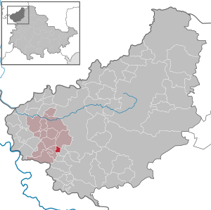
| Location of the municipality of Eichstruth in the Eichsfeld district | ||
  |
||

Eichstruth is a municipality in the Uder administrative community in the Thuringian district of Eichsfeld . With an area of 1.34 km², Eichstruth is the smallest municipality in Thuringia.

geography

Eichstruth is located in a depression between the heights of the upper Eichsfeld, with the Eichstruther head (503.0 m) in the northeast and the northern foothills of the Gobert with the Frauenberg (411.5 m) in the south. A source arm of the Walse , the Tränktalgraben, rises in the district . The Thomasquelle is located on the border with the neighboring municipality of Mackenrode.
The state road L1003 is part of the German Fairy Tale Route and connects Eichstruth with the towns in the southern and western Eichsfeld. On the road to Mackenrode is the so-called "Victory Oak", from which one has a view over the Walsetal to the Höheberg , a landscape also known as "Eichsfeldische Schweiz".
history
Eichstruth was first mentioned in a document in 1236. The name refers to a swampy area with oak trees . From 1236 to 1849 the place was in the feudal possession of the Lords of Hanstein . From 1952 to 1989 Eichstruth was in the restricted area and was therefore affected by severe restrictions in public and private matters. In 1993 Eichstruth was the district winner in the competition: " Our village should become more beautiful ".
Population development
Development of the population (December 31) :
|
|
|
|
- Data source: Thuringian State Office for Statistics
Attractions
politics
Municipal council
The Eichstruth council consists of six council members.
- Proposal for electoral group Eichstruth: 6 seats
(As of: local elections on May 25, 2014)
mayor
In the local elections in Thuringia in 2019 , Nancy Riethmüller (Eichstruth voter group) was elected mayor with 96.8 percent.
Regular events
- Fair (3rd Sunday in July)
- Sports festival (weekend before the fair)
traffic
The next stops are Uder on the Halle – Hann railway line. Münden , about 10 km north of Eichstruth, and Bad Sooden-Allendorf on the Göttingen – Bebra railway line , about 13 km west. EW Bus GmbH runs to these two places and to the district town of Heilbad Heiligenstadt on weekdays to line 13 .
literature
- Torsten W. Müller: 775 years of Eichstruth. In: Eichsfelder Heimatzeitschrift. 55 vol. (2011), issue 7/8, pages 251-252
Individual evidence
- ^ Population of the municipalities from the Thuringian State Office for Statistics ( help on this ).
- ↑ Ed. Ulrich Harteisen, Ansgar Hoppe et al .: Das Eichsfeld. Volume 79 of the series Landscapes in Germany. Verlag Böhlau , Vienna / Cologne / Weimar 2018, p. 295
- ↑ Local elections in Thuringia on May 25, 2014. Elections of the community and city council members. Preliminary results. The regional returning officer, accessed on January 29, 2017 .
- ↑ Local elections 2019 / mayor elections , mdr.de, accessed on May 28, 2019.
Web links
At the Ohmberg | Arenshausen | Asbach-Sickenberg | Berlingerode | Birkenfelde | Bodenrode-Westhausen | Bornhagen | Brehme | Width worbis | Buhla | Burgwalde | Büttstedt | Dieterode | Dietzenrode / Vatterode | Dingelstädt | Ecklingerode | Effelder | Eichstruth | Ferna | Freienhagen | Fretterode | Geisleden | Geismar | Gerbershausen | Gernrode | Glasehausen | Großbartloff | Haynrode | Heilbad Heiligenstadt | Heuthen | Hohengandern | High cross | Kella | Kirchgandern | Kirchworbis | Krombach | Küllstedt | Leinefelde-Worbis | Lenterode | Lindewerra | Lutter | Mackenrode | Marth | Lower Orschel | Pfaffschwende | Reinholterode | Rohrberg | Röhrig | Rustenfelde | Schachtebich | Schimberg | Schönhagen | Schwobfeld | Sickerode | Sunstone | Steinbach | Steinheuterode | Keyings | Services | Thalwend | Uder | Volkerode | Waxed | Wahlhausen | Blowing | Wiesenfeld | Wingerode | Wüstheuterode