Latitude
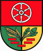
| coat of arms | Germany map | |
|---|---|---|

|
Coordinates: 51 ° 25 ' N , 10 ° 26' E |
|
| Basic data | ||
| State : | Thuringia | |
| County : | Eichsfeld | |
| Management Community : | Eichsfeld-Wipperaue | |
| Height : | 300 m above sea level NHN | |
| Area : | 24.23 km 2 | |
| Residents: | 3176 (Dec. 31, 2019) | |
| Population density : | 131 inhabitants per km 2 | |
| Postal code : | 37339 | |
| Area code : | 036074 | |
| License plate : | EIC, HIG, WBS | |
| Community key : | 16 0 61 017 | |
| LOCODE : | DE BWO | |
| Association administration address: | Weststrasse 2 37339 Breitenworbis |
|
| Website : | ||
| Mayor : | Cornelius Fütterer | |
| Location of the municipality of Breitenworbis in the Eichsfeld district | ||
Breitenworbis is a municipality in the Thuringian district of Eichsfeld . Breitenworbis is the seat of the Eichsfeld-Wipperaue administrative association .
geography
The Rhin, a left tributary of the Wipper, flows through the municipality . The landscape is characterized by the wooded ridges of the Ohm Mountains, the Harburg and the Hubenberg. Not far from the village is the Hugenworbis desert .
history
The Wallburg (Klei) on the southeastern part of the Ohm Mountains was, judging by the finds, built in the Iron Age . Line decorated ceramics were found. Wall and moat are still well preserved. The system was used to monitor the surrounding area and the traffic connection over the Hahn pass of the mountains.
In 1238, Breitenworbis was first mentioned in a document as Breytenworbetze . It belonged to Kurmainz until the secularization in 1802 . From 1802 to 1807 the place was Prussian and then became part of the Kingdom of Westphalia . From 1815 he was part of the Prussian province of Saxony . A major fire in 1859 destroyed around 100 residential houses and their outbuildings. In 1905/1906 the potash shafts were built, which were closed again in 1931.
1945 to 1949 the place belonged to the Soviet occupation zone and became part of the GDR from 1949 . From 1961 until the turnaround and reunification in 1989/90, Breitenworbis was affected by the closure of the nearby inner-German border. Since 1990 the place belongs to the re-established Free State of Thuringia. In 1991, Breitenworbis became the seat of the Eichsfeld-Wipperaue administrative association. In 2001 the Leinefelde –Breitworbis motorway section was handed over to the A 38 .
On September 1, 2009, the previously independent municipality of Bernterode was incorporated into Breitenworbis.
Population development
Development of the population (December 31) :
|
|
|
|
|
- Data source: Thuringian State Office for Statistics
politics
Municipal council
The council of Breitenworbis consists of 16 council members.
(Status: local elections 2019 )
mayor
The current mayor is Cornelius Fütterer. He was elected on June 5, 2016.
Attractions
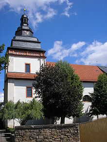
- Catholic St. Vitus Church from 1681 with vault paintings
Personalities
- Willibald Böck (1946-2016) - politician (CDU)
- Martin Kohlstedt (1988) - musician, pianist, composer and producer
- Stefan Bötticher (1992) - track cyclist
- Sebastian Stolze (1995) - football player
literature
- Helmut Godehardt, Franz Hebestreit, Bernadett Leibeling: 750 years of Breitenworb until 1238–1988 . Ed .: Council of the Municipality of Breitenworbis. Breitenworbis 1988, p. 95 .
- Wolfgang Timpel, Harald Reuße: Archaeological investigations on the desert Hugenworbis near Breitenworbis . In: Pedagogue. District cabinet Worbis (Ed.): Eichsfelder Heimathefte . Book 3. Worbis 1986, p. 197-202 .
Individual evidence
- ^ Population of the municipalities from the Thuringian State Office for Statistics ( help on this ).
- ↑ Michael Köhler: Thuringian castles and fortified prehistoric and protohistoric living spaces , Jenzig-Verlag, Jena 2001, ISBN 3-910141-43-9 , p. 159
- ↑ StBA: Area changes from January 2nd to December 31st, 2009
- ↑ City council election 2019 in Thuringia
- ^ Official journal of the administrative association "Eichsfeld-Wipperaue". June 10, 2016, accessed January 12, 2017 .


