Bernterode (Breitenworbis)
|
Bernterode
Breitenworbis municipality
|
||
|---|---|---|
| Coordinates: 51 ° 23 ′ 55 " N , 10 ° 28 ′ 33" E | ||
| Height : | 267 m above sea level NN | |
| Area : | 10.22 km² | |
| Residents : | 1309 (December 31, 2008) | |
| Population density : | 128 inhabitants / km² | |
| Incorporation : | September 1, 2009 | |
| Postal code : | 37339 | |
| Primaries : | 036074, 036076 | |
|
Location of Bernterode in Thuringia |
||
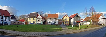
Bernterode and Bernterode-Schacht are districts of the municipality of Breitenworbis in the Thuringian district of Eichsfeld .
location
Bernterode is located in the valley of the Wipper about nine kilometers east of Leinefelde-Worbis in the Eichsfelder Kessel between the mountain ranges of the Ohmgebirge and the Bleicheröder Mountains in the north and the Dün in the south. The location is immediately framed by the Herrenberg (373 m) and Dachsberg (341 m) in the south and the Höllberg (353 m) in the north.
The place itself is connected to the surrounding villages via the state roads 2048 and 3080, the federal motorway 38 (with the Höllberg tunnel ) runs just a little north and has a stop on the Halle – Hann railway line. Münden .
The Bernterode-Schacht settlement one kilometer to the northwest , which was built when the potash works opened, also belongs to the location . It received the Kreuzkirche in 1925 .
history
In 1174, Bernterode was first mentioned as the Bernesrout and is one of the oldest villages in Eichsfeld . It belonged to Kurmainz until the secularization in 1802 . In the years 1591, 1592 and 1601 the buildings Schwerdtsche Mühle, Templer-Haus and Baderscher Hof, which still exist today, were built.
The Catholic Church of St. Martin was built in 1605, but only the tower of this original church has been preserved, as the nave was rebuilt in 1866. In 1635/1636 the plague claimed many lives and in the following years the community suffered from the Thirty Years' War and the associated marching through and billeting.
In 1802 the Eichsfeld with Bernterode was handed over to Prussia and belonged to the Kingdom of Westphalia under Napoleonic rule . From 1815 Bernterode was part of the Prussian province of Saxony . In 1822/1823 today's B 80 and in 1867 the railway (stop only in 1897) were built.
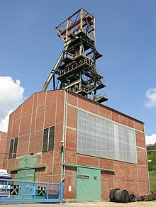
Preparations for potash mining in Bernterode-Schacht began in 1904 with the establishment of the Deutsche Kaliwerke corporation for the Bernterode potash plant . In 1905/1906 mining began in the “Prussia” shaft and in 1912 in the “Saxony” shaft , the company relocated its administrative headquarters to Bernterode. In 1907 a potassium chlorine factory was put into operation and in 1911 the stop on the Halle – Hann. Münden expanded into a train station, from which a rail connection to the shaft started. In the First World War , 52 Bernteröder fell. In 1925 the Protestant Bernteröder received their own house of worship, the Kreuzkirche .
After the potash shafts and the chlorinated potassium factory were closed in the course of the global economic crisis in 1931, construction of an army ammunition plant began in 1936 , which began producing ammunition in 1938. During the Second World War , a barbed wire-fenced camp with five barracks was built on the factory premises on the B 80. From 1943, 200 French people , later forced laborers from the Soviet Union and 50 Italian military internees , were housed in the most difficult forced labor. When the approaching front threatened the Berlin area in March 1945, the coffins of Paul von Hindenburg and his wife as well as the kings Friedrich Wilhelm I and Friedrich II of Prussia were stored in the shaft - as well as the flags and standards of the German army from 1914–1918, the files of the Foreign Office, the Kassel land registry, pictures from Prussian state museums , the library of Sanssouci , the Prussian crown jewels , valuable porcelain and 271 paintings. US troops who had occupied Bernterode in the final phase of the war transferred most of the goods to the Marburg Central Collecting Point in the US occupation zone before they vacated the place on July 2, 1945 in favor of the Red Army . Two days later, on July 4, 1945, an ammunition train exploded on the premises of the factory and destroyed most of the daytime facilities and conveyor systems. In 1953 it was taken over by the Sollstedt potash works , parts of the facilities were used as a weather shaft.
1945 to 1949 the place belonged to the Soviet occupation zone and from 1949 to the GDR . From 1961 until the turnaround and reunification in 1989/1990, Bernterode was affected by the closure of the nearby inner-German border. Since 1990 the place belongs to the re-established state of Thuringia.
On September 1, 2009, the municipality of Bernterode (near Worbis) with the two districts of Bernterode-Ort and Bernterode-Schacht voluntarily joined the municipality of Breitenworbis.
Population development
Development of the population (December 31) :
|
|
|
|
- Data source: Thuringian State Office for Statistics
coat of arms
The coat of arms was awarded on March 29, 1996. The ax symbolizes the clearing of the place, the weaver's shuttle the traditional textile industry since the Middle Ages, the waves the river Wipper .
Personalities
- Sebastian Stolze (born January 29, 1995), football player
- Willibald Böck (born December 30, 1946 - † August 2, 2016), politician
literature
- Municipality of Bernterode (Ed.): Bernterode in Eichsfeld. Our village and its people in the past and present . Heiligenstadt 1999, p. 112 .
- Norbert Degenhard: Family book of the Catholic parish of Bernterode (Eichsfeld district), 17102 to 1882. Leipzig: AMF 2009 (= Central German local family books of the AMF 26)
- Eichsfeld village chronicles. Bernterode, Breitenworbis, Deuna, Gernrode, Hüpstedt, Kirchworbis, Vollenborn . In: Maik Pinkert, Alfons Montag, André Sieland (ed.): Source editions from the Episcopal Commissariat in Heiligenstadt . tape 1 . Eichsfeldverlag, Dortmund 2001, ISBN 3-935782-02-0 , p. 456 .
Individual evidence
- ↑ Thuringian Association of the Persecuted of the Nazi Regime - Association of Antifascists and Study Group of German Resistance 1933–1945 (Ed.): Local history guide to sites of resistance and persecution 1933–1945. (= Heimatgeschichtliche Wegweiser , Volume 8 Thuringia.) Erfurt 2003, ISBN 3-88864-343-0 , p. 29.
- ↑ StBA: Area changes from January 2nd to December 31st, 2009


