
Bischofferode (Am Ohmberg)
|
Bischofferode
Rural community Am Ohmberg
|
|
|---|---|
 |
|
| Height : | 298 m above sea level NN |
| Area : | 12.21 km² |
| Residents : | 1913 (Dec. 31, 2009) |
| Population density : | 157 inhabitants / km² |
| Incorporation : | December 1, 2010 |
| Postal code : | 37345 |
| Area code : | 036077 |
 Location of the district in the rural community Am Ohmberg
|
|


Bischofferode is a district of the rural community Am Ohmberg in the Thuringian district of Eichsfeld . Until 1993 the place was a center of potash mining .
geography
Bischofferode is located on the Bode , in the northern part of the Eichsfeld near the border with Lower Saxony . The place is located about 25 kilometers (as the crow flies) northeast of the district town of Heilbad Heiligenstadt on the northern edge of the Ohm Mountains . Surrounded by mountains, the village of Bischofferode itself only has a small proportion of forest.
The highest elevations are the Ohmberg ( 528.7 m above sea level ), but its wooded summit region belongs to the neighboring village of Haynrode . The Hühnerberg ( 349.9 m above sea level ), the Hasenberg ( 343.4 m above sea level ) and the Große Heuberg (with the southern branch of the Häuserberg es) ( 389 m above sea level ) are also noteworthy. The river Bode flows through the place.
Local division
Bischofferode includes the districts of Bischofferode, Hauröden and the Thomas-Müntzer-Siedlung, which emerged from a factory settlement of the potash plant . There used to be the desert areas of Wenigenbischofferode, Husen and Popperode in the Bischofferode area.
history
Bischofferode was first mentioned in a document in 1186. In 1238 Bernhard von Worbis sold the Husen manor to the Gerode monastery ; in 1293 the church in Dietenborn also sold its possessions in Bischofferode to the monastery of the monastery. The Bischofferöder farmers received land on a long lease . In 1572 a community tavern was built. In 1608 the foundation stone was laid for St. Mary's Church , but the church was not finally completed until 1699, after 90 years of construction. The Marienkirche, which was still under construction, was consecrated as early as 1678 by Erfurt Bishop Kulusius . During the Thirty Years War , Bischofferode was ravaged by the plague (1625) and was plundered several times by Swedish troops. In the years 1670 to 1672 the half-timbered building of the mill and the Redemann bakery were built in Bischofferode. During the Seven Years' War , the village was occupied by the warring parties and plundered again. In 1771, residents of Bischofferode and Holungen litigated the abbot of the Gerode monastery unsuccessfully for release from their inherited services and burdens.
In the 18th century Bischofferode had grown to 118 houses and 636 inhabitants. On August 3, 1802, Prussian troops again occupied the area. This ended the rule of Gerode Abbey over the place. 1803 Bischofferode became Amtsdorf. At that time it had 134 houses and 851 residents.
In 1815, Bischofferode was assigned to the Prussian province of Saxony , district of Worbis. By 1816 the number of inhabitants decreased to 744. In 1871, however, according to a census, the place had 987 inhabitants again, including 19 illiterate people .
On July 1, 1886, the community's first post office was set up in Josef Wand's house. The schoolhouse was built in 1886 and 1887. As early as 1889, 237 students attended this school. In 1900 the community had 190 houses and almost 1,000 residents. The geological prospecting by test drilling revealed rich potash deposits in the region. The construction of the first pits and the necessary infrastructure began immediately. This also included the mine railway system to the Neubleicherode shaft near Hauröden, which went into operation in October 1908. Two years later, on October 1, 1910, the Großbodungen – Bischofferode section of the Bleicherode Ost – Herzberg railway was put into operation (traffic ceased in 1998).
Bischofferode was hit by a storm front on September 7, 1926; the floods caused by heavy rain caused great damage in the village.
In 1939, Polish forced laborers had to work for local farmers for the first time , and Ukrainians were added later. In 1940, the first of around 200 forced laborers from the Ukraine, Poland and France who had to do forced labor during the Second World War arrived at the Bismarckshall potash plant . In 1944, a warehouse was set up in the Wintershall AG area for the establishment of an external command of the Mittelbau-Dora concentration camp , in which concentration camp prisoners had to carry out loading and repair work on V2 rockets under inhumane conditions . The prisoners of the Kommando were " evacuated " in 1945 to the Bergen-Belsen concentration camp .
On April 10, 1945 Bischofferode was occupied by US troops. These handed over the place to the Red Army on July 4, 1945 .
The community of Bischofferode became known nationwide primarily through the hunger strike of the miners of the " Thomas Müntzer " potash mine against its intended closure, which, although the plant was still profitable at that time, was carried out on December 31, 1993 (see also Holungen ). On May 22, 1998, the place finally lost its rail connection after the railway line was abandoned.
On December 1, 2010, Bischofferode was merged with the communities of Großbodungen and Neustadt to form the community of Am Ohmberg and thus lost its independence.
Population development
Development of the population (December 31) :
|
|
|
|
|
- Data source (from 1994): Thuringian State Office for Statistics
coat of arms
Blazon : “Divided in two, a hoe in gold below, a bishop's staff on top of blue.” The coat of arms of Bischofferode is a two-part shield. In the upper area a golden bishop's staff can be seen on a blue background and in the lower area a hoe on a yellow background. It shows the origin of the place name. The bishop received the dues from the village and in order to create space for the place, the forest had to be cleared with a hoe.
Attractions
Bischofferode mining museum
The mining museum was set up by members of the Thomas Müntzer Potash Association in Bischofferode in the former operating outpatient clinic of the Bischofferode potash plant between 1996 and 1999. The museum shows exhibits, equipment and exhibits from the history of the mine and about working conditions underground. A mineral collection and historical Bergman uniforms are also on display. Another focus of the exhibition is the documentation of the workers' industrial action up to the closure of the mine in 1993. Due to financial problems, the permanent preservation of the museum is not guaranteed.
More Attractions
- Catholic Church "Maria Birth" : In 1930 the old nave was demolished and an emergency church was set up. In 1932 the construction of today's church was finished.
- Natural stone grotto next to the church
- Wayside shrines in the locality and in the hallway
- Rock formations at the "Wild Church" on the Ohmberg.

West side of the church

Mining museum
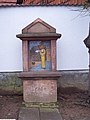
Wayside shrine - top row

Wayside shrine - Weißenborner Strasse

Natural stone grotto next to the church


Mining
In 1909 the Bismarckshall potash union was opened in the districts of Bischofferode and Holungen . From 1927 under Wintershall AG and from 1953 as the state-owned Thomas Müntzer potash plant , potash salt was mined and processed until December 31, 1993 . The protests of the potash miners in the run-up to the closure of the plant at the beginning of the 1990s briefly attracted nationwide attention. The writer Volker Braun processed the closure of the mine in Bischofferode in his 2011 story The bright heaps .
Personalities
sons and daughters of the town
- Gerhard Jüttemann (born October 10, 1951), member of the 13th and 14th German Bundestag ( PDS )
Other personalities
- Josef Averesch CSsR (1902 - 1949), Roman Catholic priest and victim of National Socialism. In January 1941, following a three-day parish mission in the parish of St. Marien, he represented the pastor for four weeks and was denounced in connection with this pastoral activity.
literature
- Heinrich Bebling: 800 years of Bischofferode . Ed .: Council of the Municipality of Bischofferode. o. O. 1986, p. 62 .
- Topographic map 4528-NO Bischofferode - Thuringian State Office for Surveying and Geoinformation - ISBN 3-86140-464-8
- Miners' deeds - miner's luck. On the history of the "Thomas Müntzer" potash plant in Bischofferode - by Burghoff, Ingrid and Lothar
- Christine Ostrowski, diary of a hunger strike. Bischofferode , Dingsda-Verlag, Querfurt 1993, ISBN 3-928498-23-1
Web links
- Website of the district of Bischofferode
- Eichsfeldprojekt - Website of the Staatliche Regelschule Bischofferode ( Memento from October 6, 2011 in the Internet Archive )
Individual evidence
- ↑ Thuringian Land Survey Office TK10 - Sheet 21-Bd-4 Steinrode , Erfurt 1988.
- ↑ Ed. Ulrich Harteisen, Ansgar Hoppe et al .: Das Eichsfeld. Volume 79 of the series Landscapes in Germany. Verlag Böhlau , Vienna / Cologne / Weimar 2018, p. 254
- ↑ StBA: Area changes from January 01 to December 31, 2010
- ↑ Thuringian State Office for Statistics (from 1994)
- ↑ Claus Peter Müller from the green. Under one roof. The reunited potash industry in a unified Germany. In Ulrich Eisenbach, Akoš Paulinyi (ed.) The potash industry on the Werra and Fulda. History of an industry that shapes the landscape. Hessisches Wirtschaftsarchiv, Darmstadt 1998, 232–233.
- ↑ Volker Braun: The light heaps. Suhrkamp, Frankfurt 2011, ISBN 978-3-518-42239-7 .
- ↑ Bernhard Sacrifice man : shaping the calibration field. Religious images of life . Cordier, Heiligenstadt / Sankt-Benno-Verlag, Leipzig 1968, p. 142.
Bischofferode with Hauröden and Thomas-Müntzer-Siedlung | Large floors with Wallrode | Neustadt with Neubleicherode