
Neustadt (Eichsfeld)
|
Neustadt
Rural community Am Ohmberg
|
|
|---|---|
.png) |
|
| Height : | 314 (282-320) m above sea level NN |
| Area : | 3.59 km² |
| Residents : | 722 (December 31, 2009) |
| Population density : | 201 inhabitants / km² |
| Incorporation : | December 1, 2010 |
| Postal code : | 37345 |
| Area code : | 036077 |
 Location of the district in the rural community Am Ohmberg
|
|


_St._Simon_und_Judas_01.jpg)

Neustadt is a district of the rural community Am Ohmberg in the Thuringian district of Eichsfeld . The rural community belonged to the Eichsfeld-Südharz administrative community until its dissolution on November 30, 2011. The place was previously called the Catholic Neustadt on the Eichsfeld to distinguish it . Neustadt consists of the towns of Neustadt and Neubleicherode .
location
Neustadt is located about 25 kilometers northeast of the district town of Heiligenstadt, east of the Ohm Mountains . The place is on a small headland between the streams Knickbach in the north and Hagebach in the east and south. The Hagebach (also called Kleine Bode) flows into the Bode at Großbodungen . Neighboring places are Großbodungen in the northeast, Wallrode in the east and Buhla in the southwest.
The district of Neubleicherode is located about two kilometers west of Neustadt. The small settlement goes back to a former potash shaft. The Marienthal forester's house is located at the edge of the forest.
history
The Hasenburg , located about three kilometers south of Neustadt, was already settled in the Neolithic Age and formed one of the most important centers of power in the Eichsfeld until the High Middle Ages. The Hasenburg last served as an imperial castle in the reign of Emperor Heinrich IV and was destroyed in 1074 during the Saxon War along with the settlement ("Civitas") of the occupying men and their families. It was located directly below the eastern slope, between the mountain and the path leading from Wallrode to Buhla today, and was rebuilt at its current location.
Neustadt is first mentioned as "Nova Civitas" in a document issued by Pope Urban IV in 1262. Carl Duval reports that the place was almost completely depopulated as a result of the plague in 1662, with only 122 surviving inhabitants. Around 1845 the population was about 1000 people, the place had 120 houses and courtyards. One of the special features of the village was the dancing linden tree , which under its branches would offer enough space for a company of soldiers. On May 7, 1843, a chapel was consecrated not far from the village.
Neustadt was laid out as a planned settlement around a large meadow and was protected by a bend and wall, some of which can still be seen. The names of the two streams (Hagen and Knick) indicate this protective function.
The place belonged to the state territory of the Archbishopric of Mainz , King Friedrich Wilhelm III , until the secularization . 1802 took possession of the entire Eichsfeld for Prussia , the media principality of Eichsfeld was created. From 1806 to 1813 the French-occupied Eichsfeld was part of the Kingdom of Westphalia , after which it was returned to Prussia after its dissolution. At the Congress of Vienna in 1815 the Eichsfeld was divided. Neustadt was assigned to the Obereichsfeld, it was added to the Worbis , which now belong to the Prussian province of Saxony . Along the northern boundary of the district there was also the border to the Untereichsfeld, but this was of no particular importance for the residents until the end of the Second World War .
Around 1900, the exploration and development of the underground potash salt deposits in Eichsfeld began. Mining enabled the creation of numerous jobs and the close-knit expansion of the rail network. Between 1945 and 1949 Neustadt belonged to the Soviet occupation zone and was from 7 October 1949 of the German Democratic Republic , he was in the district of Erfurt , county Worbis . Since 1990 the place belongs to the newly created Eichsfeldkreis in Thuringia. On December 1, 2010 Neustadt was merged with the communities of Großbodungen and Bischofferode to form the community of Am Ohmberg and thus lost its independence.
Population development
Development of the population (December 31) :
|
|
|
|
- Data source: Thuringian State Office for Statistics
coat of arms
Blazon : "In silver, a red three-mountain topped with a silver, six-spoke wheel , on top of which is a green linden tree, each bordered by two black stakes reaching to the head of the shield."
Attractions
Anger
Neustadt has a relatively large lawn on a slightly raised roundabout in the middle of the village. The village is one of a few anger villages in Eichsfeld. Immediately adjacent are the church and houses for the village community, such as the rectory, tavern and old school, as well as the village pond. It is not known whether the Anger used to have a typical Angermauer wall and a stone table.
Angerlinde
The dance linden tree, also shown in the town's coat of arms, is the town's landmark . The location of the 375-year-old giant tree is in the center of the village and has been prepared as a dance floor. With a diameter of about 14 meters, this tree covers the former dance floor with its branches. This summer linden tree was planted immediately after the Thirty Years War . She is a living witness of the new beginning after this murderous war from which the region suffered particularly. The growth of the crown “steered” human hands through trimming from the beginning. As a natural monument, the tree is historically particularly interesting and unique in Eichsfeld .
St. Simon and Jude Thaddaeus
In the village there is also the Romanesque church of St. Simon and Judah as well as listed half-timbered houses.
Way of the Cross and Forest Chapel
In the vicinity of the district of Neubleicherode there is a station path with a St. Mary's grotto and the Neustadt forest chapel .
Trinity linden tree and wayside shrine
At the junction to Neubleicherode there is a linden tree with a trinity shrine.
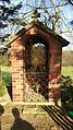
Klüschen with Pietà
At the southern exit of the village in the direction of Wallrode there is a Klüschen (pronunciation: Klüschen) with a Pietà as a wooden relief. Underneath it reads: "All of you who come along your way, pay attention and see whether a pain is ever like my pain."

Mary's grotto at the forest chapel

Trinity linden tree with wayside shrine
Klüschen with Pietà


.JPG)

literature
- Carl Duval: "Neustadt" . In: The Eichsfeld . (Reprint). Harro von Hirschheydt Verlag, Hannover-Dören 1979, ISBN 3-7777-0002-9 , p. 598-599 .
- Michael Köhler: "Hasenburg" - Thuringian castles and fortified prehistoric and early historical living spaces . Jenzig-Verlag, Jena 2001, ISBN 3-910141-43-9 , p. 128-129 .
Web links
- Neustadt - On the website of the rural community Am Ohmberg
Individual evidence
- ↑ Ground floor: special features of the village - the mighty linden tree. (after Johannes Müller) in Thüringer Tageblatt of October 27, 1984
- ↑ StBA: Area changes from January 01 to December 31, 2010
- ^ Thuringian State Office for Statistics
- ↑ Ewald Heerda: "Tanzlinde Neustadt" - discoveries in the Eichsfeld. Interesting facts from the woods and fields . Cordier Verlag, Heiligenstadt 1993, p. 46-47 .
Bischofferode with Hauröden and Thomas-Müntzer-Siedlung | Large floors with Wallrode | Neustadt with Neubleicherode