
Schwobfeld
| coat of arms | Germany map | |
|---|---|---|

|
Coordinates: 51 ° 17 ' N , 10 ° 6' E |
|
| Basic data | ||
| State : | Thuringia | |
| County : | Eichsfeld | |
| Management Community : | Ershausen / Geismar | |
| Height : | 355 m above sea level NHN | |
| Area : | 2.52 km 2 | |
| Residents: | 111 (Dec. 31, 2019) | |
| Population density : | 44 inhabitants per km 2 | |
| Postal code : | 37318 | |
| Area code : | 036082 | |
| License plate : | EIC, HIG, WBS | |
| Community key : | 16 0 61 085 | |
| Association administration address: | Kreisstrasse 4 37308 Schimberg |
|
| Website : | ||
| Mayor : | Andreas Mueller | |
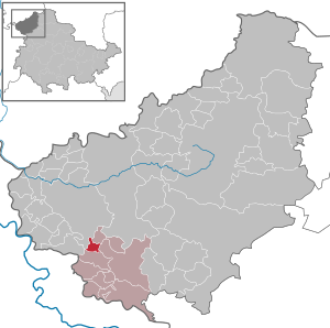
| Location of the municipality of Schwobfeld in the Eichsfeld district | ||
  |
||

Schwobfeld is a municipality in the Ershausen / Geismar administrative community in the Eichsfeld district in Thuringia .
Geographical location

The municipality of Schwobfeld is located about 10 kilometers (as the crow flies) south of the district town of Heiligenstadt on the southwestern edge of the Eichsfeld. The district is located on a higher depression between the Rachel Berg (523.4 m) to the southwest and the depth at the top (520.8 m) in the Northeast. Here is also the headwaters of the Rode , a tributary of the Frieda .
Neighboring towns are Dieterode in the north, armaments in the east, Wiesenfeld in the southeast and Weidenbach in the west.
history
The place was first mentioned in 1323 as "Swabfelde". At that time the place already belonged to Kurmainz , to the castle district of the office of Greifenstein. Today's Greifenstein ruins are located eight kilometers southeast of the town near Geismar . In a document from Gerlach von Nassau in 1364, the Landgraves of Thuringia and Margraves of Meißen gave the village to the Lords of Hanstein as a hereditary fiefdom. Schwobfeld bordered the Hessian office of Altenstein in the west, so the local conditions have always been determined by a border location. From 1802 to 1807 the place became Prussian and then became part of the Kingdom of Westphalia. From 1815 to 1945 it was part of the Prussian province of Saxony .
According to a statistical study, the village of Schwobfeld had 163 Catholic inhabitants around 1840. Schwobfeld then consisted of 24 houses, 34 stables and barns, a tavern and three community centers. The All Saints Church and the village green are in the center of the village . The school was attended by 15 school-age boys and 15 girls. A grocer (victuals dealer) and an innkeeper supplied the groceries. The total livestock included 23 horses, 68 cattle, 153 sheep, 12 goats and 38 pigs. The village corridor comprised 737 acres , of which the arable land comprised 533 acres of arable land, 13 acres of garden land, and 24 acres of meadows. Furthermore, 50 acres of community forest and 115 acres of fallow land were named.
1945 to 1949 the place came under the Soviet occupation zone and was part of the GDR from 1949 . From 1961 until the turnaround and reunification in 1989/1990, Schwobfeld was affected by the closure of the nearby inner-German border. Since 1990 the place belongs to the re-established state of Thuringia.
coat of arms
The coat of arms of the municipality, approved on March 31, 1998, refers to a fairy tale by the Brothers Grimm , which describes the adventures of seven Swabians on their stupid hike through the world. As an allusion to the own place name and "talking symbol", this representation was included in the community seal in 1951.
On a green background, the coat of arms shows seven men in silver, stepping synchronously one behind the other, who together hold a silver lance horizontally.
Population development
Development of the population (December 31) :
|
|
|
|
|
- Data source: Thuringian State Office for Statistics
politics
Municipal council
The municipal council of Schwobfeld consists of 6 councilors.
- Election proposal FFw: 4 seats
- Nomination for the home club: 2 seats
(Status: 2014 local elections)
mayor
The honorary mayor Andres Müller (FFw) was first elected in 2004, he was re-elected in 2010 and 2016.
Attractions
The "All Saints" Church (renovated from 1990 to 1993) and the village green surrounded by linden trees are designated as sights. A community center was created for the cultural events. In the hallway there are several field and weather crosses as a symbol of popular piety. To the east of the village, the striking Dieterröder cliffs rise, delimiting the edge of the valley . A popular destination for visitors is the Altenstein castle ruins, barely two kilometers away on the Hessian-Thuringian border. The former border strip is designated as a long-distance hiking trail and a nature conservation project called the Green Belt .
The Schlittstein (416 m), a dolomite bulge east of the Johannesberg within the Eichenberg – Gotha – Saalfeld fault zone , is geologically interesting .
Individual evidence
- ^ Population of the municipalities from the Thuringian State Office for Statistics ( help on this ).
- ↑ RIplus Regg. EB Mainz 2,1 n. 1773, in: Regesta Imperii Online, [1] (accessed on April 7, 2020)
- ^ Association for Eichsfeldische Heimatkunde and historical society of the Werra Valley (ed.): Der Altenstein. 675 years in the Hessian-Eichsfeld border region . Cordier, Heiligenstadt 2004, p. 20-24 .
- ↑ Carl August Nobrack: detailed geographic-statistical-topographical description of the district of Erfurt . Erfurt 1841, p. 169-170 . (Excerpt also in "Das Eichsfeld" 41. Jg. Duderstadt 1997, issue 12, p. 459.)
- ↑ 2014 municipal council elections in Thuringia - final result. Thuringian State Office for Statistics, accessed on May 25, 2017 .
- ↑ Mayoral elections in Thuringia
Web links
At the Ohmberg | Arenshausen | Asbach-Sickenberg | Berlingerode | Birkenfelde | Bodenrode-Westhausen | Bornhagen | Brehme | Width worbis | Buhla | Burgwalde | Büttstedt | Dieterode | Dietzenrode / Vatterode | Dingelstädt | Ecklingerode | Effelder | Eichstruth | Ferna | Freienhagen | Fretterode | Geisleden | Geismar | Gerbershausen | Gernrode | Glasehausen | Großbartloff | Haynrode | Heilbad Heiligenstadt | Heuthen | Hohengandern | High cross | Kella | Kirchgandern | Kirchworbis | Krombach | Küllstedt | Leinefelde-Worbis | Lenterode | Lindewerra | Lutter | Mackenrode | Marth | Lower Orschel | Pfaffschwende | Reinholterode | Rohrberg | Röhrig | Rustenfelde | Schachtebich | Schimberg | Schönhagen | Schwobfeld | Sickerode | Sunstone | Steinbach | Steinheuterode | Keyings | Services | Thalwend | Uder | Volkerode | Waxed | Wahlhausen | Blowing | Wiesenfeld | Wingerode | Wüstheuterode