
Dieterode
| coat of arms | Germany map | |
|---|---|---|

|
Coordinates: 51 ° 18 ' N , 10 ° 6' E |
|
| Basic data | ||
| State : | Thuringia | |
| County : | Eichsfeld | |
| Management Community : | Ershausen / Geismar | |
| Height : | 403 m above sea level NHN | |
| Area : | 2.78 km 2 | |
| Residents: | 75 (Dec. 31, 2019) | |
| Population density : | 27 inhabitants per km 2 | |
| Postal code : | 37318 | |
| Area code : | 036082 | |
| License plate : | EIC, HIG, WBS | |
| Community key : | 16 0 61 023 | |
| Association administration address: | Kreisstrasse 4 37308 Schimberg |
|
| Website : | ||
| Mayor : | Uwe Günther | |
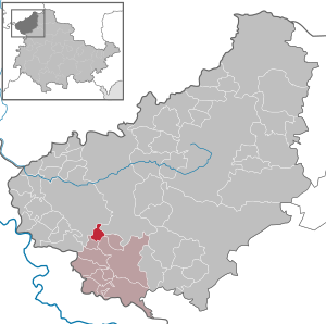
| Location of the community of Dieterode in the Eichsfeld district | ||
  |
||

Dieterode is a municipality in the Eichsfeld district in Thuringia . It belongs to the administrative community Ershausen / Geismar .

location
Dieterode is located about eight kilometers southwest of Heilbad Heiligenstadt in a depression between the Höheberg and the Rachelsberg . Neighboring places are Kalteneber in the northeast, armaments and Schwobfeld in the south and Eichstruth in the west.
history
The place was allegedly mentioned for the first time in 1184 under the name "Diethenroth", in some cases the year 1251 is also given. At times the place was desolate before it was repopulated by glassmakers at the beginning of the 16th century. The local church, dating from 1520, was rebuilt in 1785. In 1914 a station was built on the Heiligenstadt – Schwebda railway line in Dieterode. The cessation of railway operations and the dismantling of the track systems took place in 1947 due to the zone boundary at that time.
Dieterode was the seat of a general court, whose written records from the period 1779 to 1807 are now administered at the Wernigerode location of the Saxony-Anhalt State Archives . From the 16th to the 18th century, von Tastungen and the Elector of Mainz shared half of the court, and administratively it was counted under the Rusteberg office . Nothing is known about a feudal sovereignty of the place before the 16th century and was probably in regional noble possession. With the extinction of those of Tastungen, Dieterode was confiscated as a settled fiefdom from Kurmainz's share.
Population development
|
|
|
|
|
- Data source: Thuringian State Office for Statistics
politics
Municipal council
The council of Dieterode consists of six council members.
- Election proposal FFw: 6 seats
(Status: 2014 local elections)
mayor
The honorary mayor Uwe Günther (FFw) was re-elected on June 5, 2016.
Attractions


- Catholic Church “St. Georg ”from 1785
- Dieteröder Klippen , a rock break in the shell limestone southeast of the village.
- Former train station Dieterode; almost original
Personalities
- Christoph Staender (1854–1910), sculptor
literature
- Torsten W. Müller: Dieterode. From the history of an Eichsfeld village. Edited by the community administration Dieterode 2009, 160 pages
Individual evidence
- ^ Population of the municipalities from the Thuringian State Office for Statistics ( help on this ).
- ↑ Ed. Ulrich Harteisen, Ansgar Hoppe et al .: Das Eichsfeld. Volume 79 of the series Landscapes in Germany. Verlag Böhlau , Vienna / Cologne / Weimar 2018, p. 333
- ↑ Dd 6 General Court Dieterode in the State Archives Saxony-Anhalt
- ↑ Levin von Wintzingeroda-Knorr : Die Wüstungen des Eichsfeldes: Directory of the desert areas, prehistoric ramparts, mines, courts of law and waiting areas within the districts of Duderstadt, Heiligenstadt, Mühlhausen and Worbis. O. Hendel, Göttingen 1903, p. 402
- ↑ 2014 municipal council elections in Thuringia - final result. Thuringian State Office for Statistics, accessed on May 25, 2017 .
- ↑ Mayoral elections in Thuringia
Web links
At the Ohmberg | Arenshausen | Asbach-Sickenberg | Berlingerode | Birkenfelde | Bodenrode-Westhausen | Bornhagen | Brehme | Width worbis | Buhla | Burgwalde | Büttstedt | Dieterode | Dietzenrode / Vatterode | Dingelstädt | Ecklingerode | Effelder | Eichstruth | Ferna | Freienhagen | Fretterode | Geisleden | Geismar | Gerbershausen | Gernrode | Glasehausen | Großbartloff | Haynrode | Heilbad Heiligenstadt | Heuthen | Hohengandern | High cross | Kella | Kirchgandern | Kirchworbis | Krombach | Küllstedt | Leinefelde-Worbis | Lenterode | Lindewerra | Lutter | Mackenrode | Marth | Lower Orschel | Pfaffschwende | Reinholterode | Rohrberg | Röhrig | Rustenfelde | Schachtebich | Schimberg | Schönhagen | Schwobfeld | Sickerode | Sunstone | Steinbach | Steinheuterode | Keyings | Services | Thalwend | Uder | Volkerode | Waxed | Wahlhausen | Blowing | Wiesenfeld | Wingerode | Wüstheuterode