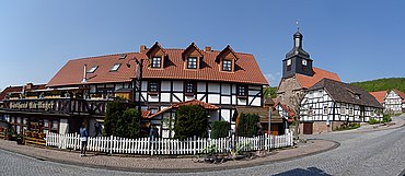
Wüstheuterode
| coat of arms | Germany map | |
|---|---|---|

|
Coordinates: 51 ° 19 ′ N , 10 ° 4 ′ E |
|
| Basic data | ||
| State : | Thuringia | |
| County : | Eichsfeld | |
| Management Community : | Uder | |
| Height : | 395 m above sea level NHN | |
| Area : | 4.93 km 2 | |
| Residents: | 581 (Dec. 31, 2019) | |
| Population density : | 118 inhabitants per km 2 | |
| Postal code : | 37318 | |
| Area code : | 036087 | |
| License plate : | EIC, HIG, WBS | |
| Community key : | 16 0 61 111 | |
| Association administration address: | Settlement 14 37318 Uder |
|
| Website : | ||
| Mayoress : | Silke Kaufold | |
| Location of the municipality of Wüstheuterode in the Eichsfeld district | ||
Wüstheuterode is a municipality in the Thuringian district of Eichsfeld . It belongs to the Uder administrative community .
location
Wüstheuterode is a place in Eichsfeld and is located on the road 1074 from Uder towards Vatterode .
history
The first documentary mention was in 1338 as "Hadewartherode". In 1424 the village was burned and completely destroyed by the troops of the imperial city of Mühlhausen as a result of a feud with the von Hanstein family . Because it was deserted for a while, it was given the nickname "Wüstheuterode", which has also been the official place name since 1806 at the latest. The place belonged to Kurmainz until the secularization in 1802 and was subject to the jurisdiction of the von Hanstein family. From 1802 to 1807 the place became Prussian and then became part of the Kingdom of Westphalia . From 1815 to 1945 he was part of the Prussian province of Saxony . In 1945 the place came to the Soviet occupation zone and was part of the GDR from 1949 . From 1961 until the turnaround and reunification in 1989/1990, Wüstheuterode was affected by the closure of the nearby inner-German border. Since 1990 the place belongs to the re-established state of Thuringia.
coat of arms
Blazon : “Split and half split; In front, in blue, Saint Boniface in silver, in his right hand holding a black bishop's staff and in his left hand holding a red missal with a silver high cross, which is pierced by a silver dagger; above in silver red flames and below in red a six-spoke silver wheel. "
Population development
Development of the population (December 31) :
|
|
|
|
|
- Data source: Thuringian State Office for Statistics
politics
Municipal council
The council of Wüstheuterode consists of eight council members.
(As of: local elections on May 25, 2014)
mayor
The honorary mayor Ms. Silke Kaufhold (FWG) was elected on June 6, 2010 and re-elected on June 5, 2016.
literature
- Reiner Merker: Wüstheuterode. A 100-year history in which events, village life and the development of this Eichsfelddorf are presented. Volume I: 1912-1972. Self-published, Wüstheuterode 2012, 72 pages, 4 color and 381 black and white images
- Reiner Merker: Wüstheuterode. The hundred-year history of an Eichsfeld village presented in words and pictures. Volume II: 1973-1993. Self-published, Wüstheuterode 2013, 72 pages, 259 color and 161 black and white images
- Reiner Merker: Wüstheuterode. The hundred-year history of an Eichsfeld village presented in words and pictures. Volume III: 1994-2004. Self-published, Wüstheuterode 2014, 72 pages, 681 color and 19 black and white images
Individual evidence
- ^ Population of the municipalities from the Thuringian State Office for Statistics ( help on this ).
- ↑ Local elections in Thuringia on May 25, 2014. Elections of the community and city council members. Preliminary results. (PDF) The State Returning Officer, accessed on May 23, 2017 .
- ↑ Local elections in Thuringia on June 5, 2016. Elections of the mayors. Preliminary results. The regional returning officer, accessed on May 23, 2017 .


