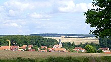
Reinholterode
| coat of arms | Germany map | |
|---|---|---|

|
Coordinates: 51 ° 25 ' N , 10 ° 12' E |
|
| Basic data | ||
| State : | Thuringia | |
| County : | Eichsfeld | |
| Management Community : | Leinetal | |
| Height : | 325 m above sea level NHN | |
| Area : | 8.73 km 2 | |
| Residents: | 765 (Dec. 31, 2019) | |
| Population density : | 88 inhabitants per km 2 | |
| Postal code : | 37308 | |
| Area code : | 036085 | |
| License plate : | EIC, HIG, WBS | |
| Community key : | 16 0 61 076 | |
| Website : | ||
| Mayor : | Reinhard Friese ( CDU ) | |
| Location of the community Reinholterode in the district of Eichsfeld | ||
Reinholterode is a municipality in the Leinetal administrative community in the Thuringian district of Eichsfeld .
Geographical location
The place is located six kilometers northeast of Heilbad Heiligenstadt near the federal highway 38 in the red sandstone hill country of the Middle Eichsfeld , which is mainly used for agriculture. Neighboring towns are Steinbach in the east, Bodenrode-Westhausen in the south, Günterode in the west and Neuendorf in the north.
The highest mountain in the district is the Rotenberg ( 407.1 m ) in the northeast towards Berlingerode . The Wildwinkelbach rises in the locality , a tributary of the Steinbach , which flows into the Leine in Bodenrode .
history
The place probably goes back to the clearing of Reinhold, the first documentary mention was in 1238. Reinholterode (until 1935 officially "Rheinholterode") belonged to Kurmainz until the secularization, from 1802 to 1945 it was part of the Prussian province of Saxony. On April 9, 1945, Reinholterode was occupied by the US Army after artillery bombardment. The graves of six German soldiers who died that day can be found in the cemetery. At the beginning of July 1945 the place came under the Soviet occupation zone and was part of the GDR from 1949. From 1961 until the turnaround and reunification in 1989/1990, Reinholterode was affected by the closure of the nearby inner-German border. Since 1990 the place belongs to the federal state, then the Free State of Thuringia.
coat of arms
Blazon : “In gold on a red cross a silver six-spoke wheel, crossed under the cross an overturned black key and a black hoe; In a raised red shield foot a silver snake. "
Population development
Development of the population (December 31) :
|
|
|
|
|
- Data source: Thuringian State Office for Statistics
politics
Municipal council
The municipal council of Reinholterode consists of eight council members.
- CDU : 8 seats
(As of: local elections on June 7, 2009)
After the 2014 election, the distribution of seats remained unchanged.
mayor
The honorary mayor Reinhard Friese (CDU) was elected on June 6, 2010.
religion
As a branch of Steinbach, Reinholterode is a Catholic church village. The church of St. Petrus in Ketten was built between 1755 and 1760/61.
Worth seeing
Sights of Reinholterode are:
- Church in the town center
- Petersclus on the road to Günterode
- Home parlor
Transport links
The place is connected to the surrounding communities via the state road L 2018 and the district road K 101 . Buses operated by the Eichsfeld district transport company connect Reinholterode with Bodenrode-Westhausen, four kilometers away, and Heiligenstadt, nine kilometers away . Heilbad Heiligenstadt is also the closest regional express train station ( Halle (Saale) - Kassel line ), while only regional trains stop in Bodenrode (towards Nordhausen and Kassel).
At the southern edge of the municipality, the federal motorway 38 and about three kilometers south of the parallel former federal road 80 pass.
Personalities
- Karl Hackethal (1901–1990), politician (CDU)
- Julius Hackethal (1921–1997), physician, book author and medical critic.
literature
- Werner and Ruth Döring: 750 years Reinholterode 1238–1988 . Ed .: Council of the community Reinholterode. S. 63 .
Individual evidence
- ^ Population of the municipalities from the Thuringian State Office for Statistics ( help on this ).
- ↑ Erhard Müller: The place names of the district of Heiligenstadt. Heilbad Heiligenstadt 1989, p. 35
- ↑ Local elections in Thuringia on June 7th, 2009. Elections for community and city council members. Preliminary results. (PDF; 1.9 MB) The State Returning Officer, accessed on March 10, 2010 .
- ↑ http://www.vg-leinetal.de/html/wahlinformationen/index_wahlinfo.htm
- ↑ Local elections in Thuringia on June 6, 2010. Elections for community and city council members. Preliminary results. The regional returning officer, accessed on June 6, 2010 .


