
Sickerode
| coat of arms | Germany map | |
|---|---|---|

|
Coordinates: 51 ° 15 ' N , 10 ° 7' E |
|
| Basic data | ||
| State : | Thuringia | |
| County : | Eichsfeld | |
| Management Community : | Ershausen / Geismar | |
| Height : | 230 m above sea level NHN | |
| Area : | 2 km 2 | |
| Residents: | 150 (Dec. 31, 2019) | |
| Population density : | 75 inhabitants per km 2 | |
| Postal code : | 37308 | |
| Area code : | 036082 | |
| License plate : | EIC, HIG, WBS | |
| Community key : | 16 0 61 086 | |
| Association administration address: | Kreisstrasse 4 37308 Schimberg |
|
| Website : | ||
| Mayor : | Gundolf Gothe | |
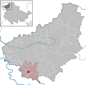
| Location of the municipality of Sickerode in the Eichsfeld district | ||
  |
||

Sickerode is a municipality in the Ershausen / Geismar administrative community in the Eichsfeld district of Thuringia .
location

The place Sickerode is about 13 km (as the crow flies) south of the district town of Heiligenstadt in the valley of the Rode , between the Gobert in the west and the Misseröder limestone ridge in the east. The highest elevation in the district is the Sickeröder Berg ( 386.4 m above sea level ).
Neighboring places are Pfaffschwende and Volkerode in the west, Wiesenfeld in the northwest, Misserode in the east and Geismar in the southeast.
history
The first reliable documentary mention comes from 1398. The church was built in 1730. The place belonged to Kurmainz until the secularization in 1802 . From 1802 to 1807 the place was Prussian and then became part of the Kingdom of Westphalia . From 1815 to 1945 it was part of the Prussian province of Saxony . Around 1840 the Prussian locations of the Eichsfeld were recorded statistically. There were 42 houses, 55 barns and stables, a parish hall, the church, the school and three mills in the village. 285 Catholic residents lived in the village. The school was attended by 26 boys and 21 girls, and they were taught by a village school teacher. Trades and trades are mentioned in the place: two tailors, two joiners, a blacksmith, a paver, a machine and mill builder, two innkeepers. The village corridor comprised 617 acres , of which the arable land comprised 504 acres of arable land, 15 acres of garden land and 35 acres of meadows. In addition, 38 acres of community forest and 24 acres of fallow land were named. The yield from the fields was estimated to be low. The total livestock consisted of 7 horses, 56 cattle, 65 sheep, 27 goats and 34 pigs. There were three mills powered by the Rode river - the Thormühle , the Spitzmühle and the Obermühle .
1945 to 1949 the place came under the Soviet occupation zone and was part of the GDR from 1949 . It was incorporated into Pfaffschwende on July 1, 1950, but became independent again on November 1, 1953 when it was separated from this community. From 1961 until the turnaround and reunification in 1989/1990, Sickerode was affected by the closure of the nearby inner-German border . Since 1990 the place belongs to the re-established state of Thuringia.
Population development
Development of the population (December 31) :
|
|
|
|
- Data source: Thuringian State Office for Statistics
- 1) Michael Rademacher: German administrative history from the unification of the empire in 1871 to the reunification in 1990. (Online material for the dissertation, Osnabrück 2006).
politics
Municipal council
The council of Sickerode consists of 6 council members.
- Electoral alliance FWG: 6 seats
(Status: 2014 local elections)
mayor
The honorary mayor Gundolf Gothe (FWG) was elected mayor for the first time on January 30, 2000; he was re-elected in 2004, 2010 and 2016. In the local elections in Thuringia 2019 , Thiemo Weinrich (Free Voters) was elected as his successor with 100 percent.
Individual evidence
- ^ Population of the municipalities from the Thuringian State Office for Statistics ( help on this ).
- ↑ Erhard Müller: The place names of the district of Heiligenstadt. Heilbad Heiligenstadt 1989, p. 42.
- ↑ Carl August Nobrack: detailed geographic-statistical-topographical description of the district of Erfurt . Erfurt 1841, p. 169 .
- ↑ Volker Große, Klaus Herzberg: Spitzmühle / Thormühle / Obermühle . In: Maik Pinkert (Ed.): Mühlen im Obereichsfeld. A compendium . Eichsfeld-Verlag, Heiligenstadt 2008, p. 302-306 .
- ↑ 2014 municipal council elections in Thuringia - final result. Thuringian State Office for Statistics, accessed on May 25, 2017 .
- ↑ Mayoral elections in Thuringia
- ↑ Local elections 2019 / mayor elections , mdr.de, accessed on May 28, 2019.
Web links
At the Ohmberg | Arenshausen | Asbach-Sickenberg | Berlingerode | Birkenfelde | Bodenrode-Westhausen | Bornhagen | Brehme | Width worbis | Buhla | Burgwalde | Büttstedt | Dieterode | Dietzenrode / Vatterode | Dingelstädt | Ecklingerode | Effelder | Eichstruth | Ferna | Freienhagen | Fretterode | Geisleden | Geismar | Gerbershausen | Gernrode | Glasehausen | Großbartloff | Haynrode | Heilbad Heiligenstadt | Heuthen | Hohengandern | High cross | Kella | Kirchgandern | Kirchworbis | Krombach | Küllstedt | Leinefelde-Worbis | Lenterode | Lindewerra | Lutter | Mackenrode | Marth | Lower Orschel | Pfaffschwende | Reinholterode | Rohrberg | Röhrig | Rustenfelde | Schachtebich | Schimberg | Schönhagen | Schwobfeld | Sickerode | Sunstone | Steinbach | Steinheuterode | Keyings | Services | Thalwend | Uder | Volkerode | Waxed | Wahlhausen | Blowing | Wiesenfeld | Wingerode | Wüstheuterode