Forge heads
| Forge heads | ||
|---|---|---|
|
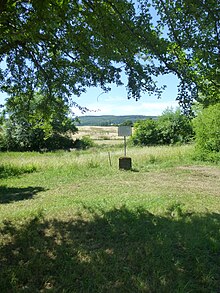
The forge heads near Eichenberg from the south |
||
| height | 251.6 m above sea level NHN | |
| location | near Niedergandern ; District of Göttingen , Southern Lower Saxony ( Germany ) | |
| Mountains | Weser-Leine-Bergland | |
| Coordinates | 51 ° 22 '34 " N , 9 ° 55' 43" E | |
|
|
||
| particularities | Südfuß: The border triangle Hessen – Lower Saxony – Thuringia | |
The forge heads are a 251.6 m above sea level. NHN high elevation of the Oberer Leinegraben in the district of Niedergandern in the southern Lower Saxony district of Göttingen at the border triangle Hesse-Lower Saxony-Thuringia .
geography
location
The forge heads rise about 2 km south-southwest of Niedergandern , a district of Friedland in the district of Göttingen in Lower Saxony , and immediately east of Eichenberg Dorf , a district of Neu-Eichenberg and at the same time a railway junction at the Eichenberg train station in the neighboring Werra-Meißner district in Hesse , and 1.3 km west-northwest of Hohengandern in the Thuringian district of Eichsfeld .
To the northeast the landscape of the Schmiedeköpfe falls into the valley of the Leine in the area of Niedergandern, Besenhausen , Hottenrode (all in Lower Saxony) and Kirchgandern ( Thuringia ), to the east it joins Hohengandern (Thuringia), to the south the landscape leads to Almas Höhe ( 305.5 m ) above and to the west rises the up to 477.2 m high sand forest (Hessen).
To the west past the Schmiedeköpf flows in a south-north direction the Leine tributary Hasengraben , which rises at Almas Höhe and touches the border triangle.
Natural allocation
The forged heads belong in the natural spatial main unit group Weser-Leine-Bergland (No. 37), in the main unit Leine-Ilme-Senke (372) and in the subunit Oberer Leinegraben (372.7) to the natural area Eichenberg-Hohenganderner Hänge and Keuperhügel (372.70).
Protected areas
Parts of the Lower Saxon landscape protection area Leinebergland ( CDDA no. 322560; designated 1986; 257.06 km² in size) lie on the Schmiedeköpf . Parts of the Thuringian bird sanctuary, Werrabergland, south-west of Uder (VSG No. 4626-420; 84.33 km²) extend up to the elevation from the south .
Hesse-Lower Saxony-Thuringia border triangle
About 100 m south of the summit of the Schmiedeköpfe is the border triangle Hesse-Lower Saxony-Thuringia (approx. 233 m ; ⊙ ), where the German states of Hesse, Lower Saxony and Thuringia border each other.
The Landgraviate of Hesse , the Electorate of Braunschweig-Lüneburg and the Electorate of Mainz used to border there , after the Congress of Vienna (1814-1815) the Electorate of Hesse , the Kingdom of Hanover and the Kingdom of Prussia , which is why the three-country stone there was marked with the inscriptions KFH , KH and KP wears. In the vernacular it is said: Sometimes teachers from Eichenberg ( KFH ; Hessen), Reckershausen ( KH ; Lower Saxony) and Hohengandern ( KP ; Thuringia) met at Dreiländerstein to play with cards , each of them sitting in their (then) country.
During the Cold War (1945–1990) the boundary stone formed a border point along the inner-German border , from 1945 between the American (ABZ) and British occupation zones (BBZ) in the west and the Soviet occupation zone (SBZ) in the east, and from 1949 between the Federal Republic of Germany (FRG) in the west and the German Democratic Republic (GDR) in the east. The Iron Curtain and the Kolonnenweg led past , which once served as a border control route and is now used as a hiking trail. From about 1970 to 1976 there was an observation post (OP Oscar) of the US armed forces with a wooden tower and helipad on the Schmiedeköpf.
Since October 3, 1990, the day of German unity , the boundary stone has marked the border between Hesse, Lower Saxony and Thuringia. He is now in the Green Belt Germany . The Eichenberger Waldbahn tracks have been located on the northern slope of the Schmiedeköpfe since 1989 .
Web links
Individual evidence
- ↑ a b c Map services of the Federal Agency for Nature Conservation ( information )
- ↑ The border triangle of Hesse-Lower Saxony-Thuringia in notizen.netzjahre.com
- ↑ Article Border disputes - The Lower Saxony-Central German border on the lower Werra ( Memento of the original from January 12, 2016 in the Internet Archive ) Info: The archive link was automatically inserted and not yet checked. Please check the original and archive link according to the instructions and then remove this notice. , on neu-eichenberg.net


