Sand forest
| Sand forest | ||
|---|---|---|
|
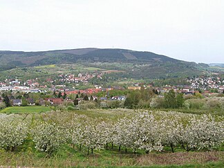
View from the waiting mountains north-northeast over Witzenhausen to the sand forest with the transmission tower on the mountain there on the sharpness |
||
| Highest peak | On the sharpness ( 477.2 m above sea level ) | |
| location | near Witzenhausen ; Werra-Meißner district and Göttingen district ; Hessen , Lower Saxony ( Germany ) | |
| part of | Lower Werrabergland in the East Hessian highlands | |
| Classification according to | Handbook of the natural spatial structure of Germany | |
|
|
||
| Coordinates | 51 ° 22 '6 " N , 9 ° 52' 55" E | |
| rock | Red sandstone | |
| surface | 31 km² | |
The sand forest is up to 477.2 m above sea level. NHN high mountain range in the Hessian Werra-Meißner district and with a small proportion in the Lower Saxony district of Göttingen . It is located near the border triangle Hesse-Lower Saxony-Thuringia, immediately north of the core town of Witzenhausen in Hesse .
geography
location
The sand forest is, viewed clockwise, between the core city of Witzenhausen in the south, Hedemünden in the west, Atzenhausen and Mollenfelde in the north and Eichenberg Dorf in the east. The ridge north- east of the Werra is about 8 km long and 4 km wide in a north-west-south-east direction; its area is around 31 km².
Geology and landscape
The sand forest consists mainly of red sandstone and is completely covered with forest in the north and east; in the western part there is also agricultural land. It is the headwaters of many small tributaries from the Werra and Leine , including Bessientalsbach , Dieffenbach , Hübenbach , Hüttenborn , Molle and Wolfsbach , which flow in the ridge or at its edges.
Natural allocation
The sand forest forms in the natural spatial main unit group Osthessisches Bergland (No. 35) and in the main unit Lower Werrabergland (358) the subunit sand forest (358.9). To the southeast, the landscape falls into the subunit Neuseesen-Werleshäuser heights (358.8) and to the south over southwest to west into the subunit Witzenhausen-Hedemündener Werra valley (358.4). To the northwest via north to northeast it leads into the natural area of Dransfeld plateaus (371.15), which is part of the main unit group Weser-Leine-Bergland (37) and the main unit Solling foreland (371) to the subunit southern Solling foreland (371.1), and to the east into the natural area Eichenberg-Hohenganderner Hänge and Keuperhügel (372.70), which belongs to the sub-unit Oberer Leinegraben (372.7) in the main unit Leine-Ilme-Senke (372) .
mountains
The mountains and elevations of the sand forest include - sorted by height in meters (m) above sea level (NHN):
- On the sharpness (477.2 m), west-southwest of Eichenberg village
- nameless (442 m), south-southwest of Neuenrode (Großes Holz)
- Steinköpfe (413 m), east-northeast of Albshausen
- nameless (approx. 380 m), southeast of Berlepsch-Ellerode
- Kobelsberg (367.8 m), southeast of Albshausen
- Badenstein (356 m), north-northwest of Witzenhausen
- Tremberg (approx. 270 m), north-northwest of Gertenbach
- Rabensberg (227.4 m), north of Witzenhausen
Protected areas
Parts of the Leinebergland landscape protection area ( CDDA no. 322560; designated 1986; size 257.06 km² ) and the fauna, flora and habitat areas of the Werra and Wehretal (FFH no. 4825-302; 244.8191 km² ) lie on the sand forest ) and the Leinholz mouse-ear hunting area (FFH no. 4625-331; 3.4009 km²).
Sightseeing and hiking
Berlepsch Castle stands on a small hilltop in the sand forest near Berlepsch-Ellerode-Hübenthal . Numerous hiking trails lead through the forested ridge, in particular - between Mollenfelde and Witzenhausen - the European long-distance hiking trail E6 and, among other things, past Berlepsch Castle.
Individual evidence
- ↑ a b c Map services of the Federal Agency for Nature Conservation ( information )
- ^ Hans-Jürgen Klink: Geographical land survey: The natural space units on sheet 112 Kassel. Federal Institute for Regional Studies, Bad Godesberg 1969. → Online map (PDF; 6.9 MB)

