Dietzenrode
|
Dietzenrode
Dietzenrode / Vatterode municipality
Coordinates: 51 ° 17 ′ 43 ″ N , 10 ° 0 ′ 49 ″ E
|
||
|---|---|---|
| Height : | 194 m above sea level NN | |
| Incorporation : | March 15, 1974 | |
| Incorporated into: | Wüstheuterode | |
| Postal code : | 37318 | |
| Area code : | 036087 | |
|
Location of Dietzenrode in Thuringia |
||
|
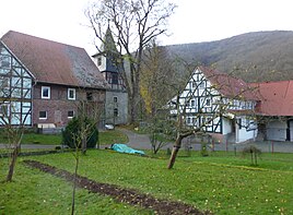
Place view
|
||
Dietzenrode is a district of the Dietzenrode / Vatterode municipality in the Eichsfeld district in Thuringia .
location
Dietzenrode lies in the Walsetal and is bounded by the Dietzenröder Stein and by the Höheberg just behind the village. The Walse flows into the Werra near the village . The village is accessible from the state road 1003. This road leads through the narrow valley and connects both partner villages with each other.
history
The village was first mentioned on September 15, 1288. Originally the village was under the authority of the Fulda Abbey . This gave the place to fief in other hands, which have often changed. The village chronicle reports on this in detail. Until 1849 Dietzenrode belonged to the Hanstein General Court.
On July 1, 1950, Vatterode was incorporated into Dietzenrode. The Dietzenrode community was incorporated into the Wüstheuterode community on March 15, 1974 . On June 1, 1990, Dietzenrode and Vatterode were spun off from Wüstheuterode. They now formed the new Dietzenrode / Vatterode community .
Attractions
- St. Nikolai village church
- The historic town center was entered as a monument ensemble in the monuments book of the Free State of Thuringia in June 2018 .
Web links
Individual evidence
- ^ Wolfgang Kahl : First mention of Thuringian towns and villages. A manual. Verlag Rockstuhl, Bad Langensalza, 2010, p. 55, ISBN 978-3-86777-202-0 .
- ↑ Private website for the location.Retrieved on August 24, 2012
- ↑ Thuringian State Gazette No. 25/2018, page 718


