Eichenberg (New Eichenberg)
|
Eichenberg
Municipality Neu-Eichenberg
Coordinates: 51 ° 22 ′ 16 ″ N , 9 ° 54 ′ 0 ″ E
|
|
|---|---|
| Height : | 275 (260-315) m above sea level NHN |
| Area : | 8.53 km² |
| Residents : | 766 (December 31, 2015) |
| Population density : | 90 inhabitants / km² |
| Incorporation : | 1st February 1971 |
| Postal code : | 37249 |
| Area code : | 05542 |
|
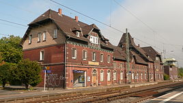
Station building
|
|

Eichenberg is the largest part of the municipality of Neu-Eichenberg in the Werra-Meißner district in North Hesse . It consists of Eichenberg Dorf and Eichenberg Bahnhof.
Geographical location
Eichenberg village is located 2.1 km west-southwest of the southern foot of the forged heads ( 251.6 m above sea level. NHN ) located border triangle Hesse-Thuringia-Saxony (about 233 m ). To the north of the village (at 260 to 315 m ) there is Berge , to the north -northeast is Hebenshausen , to the east-north-east beyond the federal highway 27 and 500 m to the west-north-west of the triangle is the Eichenberg district of Eichenberg Bahnhof (approx. 230 to 250 m ) with the Eichenberg train station , to the southeast Arnstein Castle , south-south-west is Unterrieden and south-west Witzenhausen . To the west rises the highest point of the sand forest with Auf der Schärer ( 477.2 m ) .
history
The village (today's Eichenberg Dorf) was first mentioned in 1258. The place belonged to the Hessian office Ludwigstein / Witzenhausen until 1821 and then to the district of Witzenhausen . During the French occupation, it belonged to the canton of Friedland in the Kingdom of Westphalia (1807-1813).
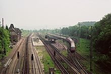
Eichenberg Bahnhof was not built until the Halle – Hann railway line was built. Münden around the station in 1858, and later the Göttingen – Bebra line was added. Both railway lines meet at the Eichenberger Gleisdreieck, northeast of Eichenberg Bahnhof, and lead from the Gleisdreieck through the station to the southwest; In addition, the Velmeden – Eichenberg railway ended at the station . In the middle of the 19th century, lignite was mined on the outskirts .
On February 1, 1971, the municipality of Eichenberg was merged with four other places to form the new municipality of Neu-Eichenberg as part of the regional reform in Hesse .
Attractions
The most famous building is Arnstein Castle, about 1 km south-east of Eichenberg Dorf on a hill .
The center of Eichenberg Dorf is a listed building . In addition to numerous half-timbered houses, this also includes the village church and the former court square with the remains of a stone table framed by lime trees. On the western edge of the village is the Karlsbrunnen with a periodically interrupted pouring of water.
At the southern exit of Eichenberg Dorf you will find the “Malstein”, also called the “Mainzer Rad”; it is a memorial stone decorated with a Maltese cross, the original meaning of which is unknown.
Immediately south of the Eichenberger Gleisdreieck lies the museum railway area of the Eichenberger Waldbahn .
Infrastructure
In Eichenberg there is a village community center , children's playgrounds and a football field .
Personalities
- Erpo von Bodenhausen (1897–1945), Lieutenant General
- Walter Mühlhausen (* 1956), historian
Individual evidence
- ^ Eichenberg, Werra-Meißner district. Historical local dictionary for Hessen. (As of February 10, 2015). In: Landesgeschichtliches Informationssystem Hessen (LAGIS).
- ↑ Current population figures of the Neu-Eichenberg community, accessed on March 27, 2016, on neu-eichenberg.de (official homepage)
- ↑ Map services of the Federal Agency for Nature Conservation ( information )
- ↑ Eichenberg Bahnhof ( Memento from March 4, 2016 in the Internet Archive ), on neu-eichenberg.net
- ^ Municipal reform: mergers and integration of municipalities from January 20, 1971 . In: The Hessian Minister of the Interior (ed.): State Gazette for the State of Hesse. 1971 No. 6 , p. 248 , item 328, paragraph 35 ( online at the information system of the Hessian state parliament [PDF; 6.2 MB ]).
- ^ Federal Statistical Office (ed.): Historical municipality directory for the Federal Republic of Germany. Name, border and key number changes in municipalities, counties and administrative districts from May 27, 1970 to December 31, 1982 . W. Kohlhammer, Stuttgart / Mainz 1983, ISBN 3-17-003263-1 , p. 409 .
- ↑ NN: Eichenberg . In: Hessischer Heimatbund (Hrsg.): Witzenhausen district. Handbook of the Hessian Homeland Federation . tape IV . JA Koch Buchdruckerei, Marburg a. d. Lahn 1971, p. 154 f .
-
↑ Eichenberger Waldbahn , on eichenberger-waldbahn.de;
see also: Eichenberger Waldbahn , on wiki-goettingen.de
Web links
- District Eichenberg on the website of the community Neu-Eichenberg.
- Eichenberg, Werra-Meißner district. Historical local dictionary for Hessen. In: Landesgeschichtliches Informationssystem Hessen (LAGIS).
- Literature about Eichenberg in the Hessian Bibliography


