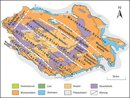
Eichsfeld plaice
The Eichsfeld floe is the Northwest thüringen and neighboring southern Lower located and extending in the NNE-SSW-direction Scholle . With the Ohmgebirgs graben zone, it delimits the Thuringian Basin and its edge plates to the northwest.
The plaice includes the western part of the Ohmgebirge and the Düns , the northern and western part of the Upper Eichsfeld to the Eichenberg – Gotha – Saalfelder fault zone , as well as the Eichsfeld hill country and the Eichsfeld basin , including its Lower Saxony parts.
structure
Various layers of shell limestone and red sandstone are involved in the Eichsfeld plaice . Individual chalk deposits come to light in the area of the Ohmgebirgsgrabenzone . The floe is divided by structures that strike NNE-SSW:
- Ohmgebirgsgrabenzone ( Sonnenstein , Klien , Richteberg )
- Duderstädter saddle and western part of the Leinefeld saddle
- Gelliehäuser Fault ( Hengstberg , Kronenberg , Die Gleichen , Eschenberg , Rohrberg , Heinebrink , Rusteberg )
- Rengelröder disorder ( Wessen , Steinberg , Dietzenberg )
- Martinfeld saddle
Limitations
To the southeast, the Eichsfeld-Scholle is delimited beyond the Ohmgebirgs-Grabenzone by the Thuringian Basin with the Bleicherode – Stadtrodaer Scholle and the Mühlhausen – Orlamünder Scholle , to the southwest by the Eichenberg – Gotha – Saalfelder fault zone , to the northwest by the eastern edge of the Leinetal and in the north by the Zechstein deposits in the southern Harz.
Individual evidence
- ^ Dietrich Franke: Regionalgeologie Ost - Geological Online Lexicon for East Germany
- ↑ Helmut Heiland: Geology of the Eichsfeldes (14). Plate tectonics and its effects on the Heinebrink near Rohrberg . In: Eichsfelder Heimatzeitschrift issue 11/12 2018, pp. 341–342
