Rusteberg
| Rusteberg | ||
|---|---|---|
|
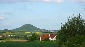
The Rusteberg seen from the west |
||
| height | 397.6 m above sea level NHN | |
| location | Eichsfeld district , Thuringia | |
| Coordinates | 51 ° 23 '10 " N , 10 ° 0' 12" E | |
|
|
||
| Type | Zeugenberg | |
| rock | Shell limestone , red sandstone | |
The Rusteberg is 397.6 m above sea level. NHN high mountain in Eichsfeld in northwest Thuringia ( Germany ).
location
The Rusteberg is located in the west of the Eichsfeld district , in the border area with the Göttingen ( Lower Saxony ) and Werra-Meißner ( Hesse ) districts. It is located about 9 kilometers west of the district town of Heilbad Heiligenstadt between the towns of Marth in the south and Rustenfelde in the north. The federal motorway 38 with the Heidkopf tunnel runs not far to the north .
Natural allocation
According to the natural spatial structure in the Kassel sheet, the mountain is still part of the Reinhäuser Wald (No. 373.2) natural area within the Göttingen-Northeimer Wald (No. 373). The Rusteberg is located along a fault zone running in a north-south direction between the Upper and Middle Buntsandstein. Orographically , the Zeugenberg , south of the Rustebach , can also be added to the hill country of the central Eichsfeld .
According to the internal structure of Thuringia ( The Natural Spaces of Thuringia ), it is assigned to the shell limestone unit Werrabergland-Hörselberge .
Origin of name
There are several possibilities for the origin of the name Rusteberg:
- The closest is the tree name “rust”, derived from Middle High German, for elm or elm , as the elm used to be more common in the Eichsfeld;
- from Middle Low German "roste, ruste" for rest, lingering;
- word for jewelry, equipment, weapons derived from the New High German “arm” and Old High German “(h) rusten”.
There may also be a mixture of these name documents.
particularities

The wooded hilltop made of shell limestone sits on top of the surrounding red sandstone landscape as a witness mountain . Due to its dominant location above the Leinetal , it was used as a fortified facility early on. In 1132, Rusteberg Castle was named as the official seat of the Archbishops of Mainz . In the 17th century the castle was abandoned and fell into disrepair. At the eastern foot of the hilltop, Rusteberg Castle was built as the Mainz office in the middle of the 18th century . This is still used as a clinic today. Only a few ruins remain from the castle.
A 17 hectare landscape protection area ( LSG Rusteberg ) is designated on the mountain . The hilltop, on which a radio mast still stands today, is not itself a vantage point, but from the edge of the forest there are beautiful views of western Eichsfeld and the neighboring regions in Hesse and Lower Saxony.
Individual evidence
- ↑ Map services of the Federal Agency for Nature Conservation ( information )
- ↑ Hans-Jürgen Klink: Geographical land survey: The natural space units on sheet 112 Kassel - Federal Institute for Regional Studies, Bad Godesberg 1969 → online map
-
^ Walter Hiekel, Frank Fritzlar, Andreas Nöllert and Werner Westhus: The natural spaces of Thuringia . Ed .: Thuringian State Institute for Environment and Geology (TLUG), Thuringian Ministry for Agriculture, Nature Conservation and Environment . 2004, ISSN 0863-2448 . → Natural area map of Thuringia (TLUG) - PDF; 260 kB → Maps by district (TLUG)
- ↑ Erhard Müller: The place names of the district of Heiligenstadt. Heilbad Heiligenstadt 1989, page 38.

