
Pure houses forest
| Pure houses forest | ||
|---|---|---|
 View from Bocksbühl over the Reinhäuser Forest |
||
| Highest peak | Bocksbühl ( 437 m above sea level ) | |
| location | District of Göttingen , South Lower Saxony | |
| part of | Göttingen-Northeimer Wald , Weser-Leine-Bergland | |
| Classification according to | Handbook of the natural spatial structure of Germany | |
|
||
| Coordinates | 51 ° 27 ' N , 10 ° 1' E | |
| rock |
Red sandstone ( shell limestone ) |
|
| particularities | Climbing area | |

The Reinhäuser Forest is a mountain range up to 437 m high and a wooded area of the Leinebergland in the district of Göttingen in southern Lower Saxony , Germany .
geography
The Reinhäuser Forest is a small ridge east of the eponymous village Reinhausen , located on the edge of the Leinegraben , south of the Göttingen Forest and northwest of the state border to Thuringia . The district town of Göttingen is about five kilometers from its north-western edge.
Natural allocation
The Reinhäuser Forest as part of the Lower Saxony mountainous region is assigned as follows according to sheet 112 :
-
(to 37 Weser-Leine-Bergland )
-
(to 373 Göttingen-Northeimer Wald )
- 373.2 Pure houses forest
-
(to 373 Göttingen-Northeimer Wald )
The natural area of the pure house forest
The mountain and forest area of the Reinhauser Forest in the narrower sense is to be distinguished from the natural area of the Reinhauser Forest within the Göttingen-Northeimer Forest. The natural area also includes the mountainous country north of the garden up to the Hengstberg near Mackenrode and in the southeast just about crosses the border to Thuringia .
The entire landscape is bounded by the following natural areas:
- Göttinger Leinegraben in the west
- Göttingen Forest in the northwest
- Nörten forest in the extreme northeast
- Lower Eichsfeld in the east and southeast
- Oberer Leinegraben in the south
nature
The predominantly wooded mountain area (mixed beech forest with individual coniferous forests) lies on a red sandstone slab and is overlooked in the south and east by individual witness mountains made of shell limestone along fault zones . Flatter slopes and wider valleys are also used for agriculture. The landscape is structured by the Garte , Wendebach and Schleierbach tributaries to the right of the Leine . In particular, the Wendebach and its small side valleys have severely crushed the red sandstone and formed an impressive rocky landscape. The Reinhäuser forest is part of the conservation area, LSG Leinebergland , large parts of the Reinhäuser forest in the strict sense as FFH -region Reinhäuser Forest expelled.

Rocks near Appenrode
Reinbach
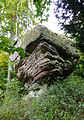
Rocks on the Terkenberg


mountains

The mountains of the Reinhausen Forest in the narrower sense include:
- Bocksbühl (437 m), west of Ludolfshausen
- The same (a pair of mountains with 430 and 428 m), southwest of Gelliehausen
- Fritzeberg (427.0 m), west of Ludolfshausen
- Eschenberg (407.8 m), north of Bremke
- Steinkopf (372.4 m), north of Reckershausen
- Terkenberg (340.1 m), north of Ludolfshausen
- nameless mountain (321.7 m), west of Bremke (southeast of the Hurkutstein)
- Knüll (321.7 m), west of Bettenrode
- Speerberg (320.1 m), east of Ballenhausen
Other mountains in the Reinhäuser Wald natural area include:
- Rohrberg (415.4 m), west of Rohrberg, Eichsfeld district
- Hengstberg (415 m), south of Mackenrode
- Rusteberg (397.6 m), north of Marth, Eichsfeld district
- Kronenberg (385 m), west of Sattenhausen
- Heidkopf (353.8 m), north of Rustenfelde, border area of the Eichsfeld and Göttingen land trip
- Kahlberg (315.5 m), southeast of Groß Lengden


Attractions
The Reinhausen Forest region is an interesting hiking area and, with its sandstone rock formations, also an important climbing area ( Ischeröder Switzerland ). Sights include:
- Rock formations with the Hurkutstein and Jägerstein
- Waldbühne near Bremke
- former monastery church in Reinhausen
- Castle ruins on the Alte Gleichen
- Bodenhausen castle ruins near Ballenhausen
- Sandstone arch bridge in Ludolfshausen
- Historic Gartetal spinning mill near Klein Lengden
Individual evidence
- ↑ a b c Map services of the Federal Agency for Nature Conservation ( information )
- ↑ Hans-Jürgen Klink: Geographical land survey: The natural space units on sheet 112 Kassel - Federal Institute for Regional Studies, Bad Godesberg 1969 → online map