
The same
| The same | ||
|---|---|---|
 Mountain couple The same |
||
| height | 432 m above sea level NHN | |
| location | near Gelliehausen ; District of Göttingen , Lower Saxony ( Germany ) | |
| Mountains | Weser-Leine-Bergland | |
| Coordinates | 51 ° 28 '2 " N , 10 ° 2' 19" E | |
|
||
| particularities | Similar castles | |

The same is one to 432 m above sea level. NHN high mountain couple in the Weser-Leine-Bergland . They are located near Gelliehausen in the Lower Saxony district of Göttingen ( Germany ).
The two twin mountains are called Alte Gleichen ( 432 m ; southern mountain) and Neue Gleichen ( 428 m ; northern mountain). They used to be the location of two castles, the Gleichen castles , and are the namesake of the municipality of Gleichen .
geography
location
The twin mountains rise in the center of the municipality of Gleichen directly southwest of Gelliehausen and north of Appenrode , both of which belong to the municipality of Gleichen; A little further south is the Bremke district of Gleichen . Their peaks are about 360 m apart and are located south of the garden and northeast of the Wendebach , both right and eastern tributaries of the Leine . Eschenberg ( 407.8 m ) is located to the south-east of the Gleichen .
Natural allocation
The same belong in the natural spatial main unit group Weser-Leine-Bergland (No. 37) and in the main unit Göttingen-Northeimer Wald (373) to the subunit Reinhäuser Wald (373.2).
geology
The same and the neighboring Eschenberg are witness mountains . They consist of shell limestone that has already been removed in the surrounding areas by the weather and water. So you can find soils of the red sandstone in the lower surrounding area today .
Nature and protected areas
Gooseberries can also be found on the wooded Alte Gleichen as cultural relic plants . Parts of the Leinebergland landscape protection area ( CDDA no. 322560; designated 1986; 257.06 km² in size) and the Unteres Eichsfeld bird protection area (VSG no. 4426-401; 137.1 km²) are located on the same . The fauna-flora-habitat area Reinhäuser Wald extends to the lower south-west slope (FFH no. 4525-331; 12.0792 km²).


Similar castles
The two equals were crowned by two hilltop castles at the time of Henry the Lion . They were built around 1100 by the Counts of Reinhausen, who converted their ancestral castle in Reinhausen into a canon monastery ( Reinhausen Monastery ). After that, the castles changed hands several times. Finally, around 1270, they came to the Lords of Uslar , ministerials at Uslar Castle . Not long afterwards, the von Uslar family divided the assets into the lines of old equals and new equals. The Neuengleichen office fell to the Landgraves of Hesse in 1451 , while the Altenleichen court remained under Guelph suzerainty. Only in the course of the Congress of Vienna was the property of Neuengleichen ceded to the Kingdom of Hanover and from here returned to the von Uslar family (auf Altenleichen), who have called themselves von Uslar-Gleichen since 1825 .
The castles of equals were never conquered in numerous feuds, but were given up in the 16th century. The residents moved to the former supply yards in the area, the castles fell into disrepair except for small remains of ruins, which are mainly still visible on the Alte Gleichen.
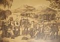
The Göttingen student union Holzminda in front of the equals; Expression of their life bond (around 1860)

Memorial plaque on the Alte Gleichen


Trivia
The Göttingen mathematician David Hilbert occasionally asked students in his lectures why the same people are called “the same”. They neither look the same nor are they the same height. Since no one knew an answer to this, he answered himself: because they are the same distance from each other .
Transport links and hiking
The narrow road that leads from Gelliehausen through Appenrode to Landesstraße 568, which runs to Bremke, leads east to south past the Gleichen . The mountains can be climbed on foot, for example from Appenrode and Gelliehausen. One possible hiking route leads over both mountains and the Eschenberg.
Web links
- Entry by Stefan Eismann on peers in the scientific database " EBIDAT " of the European Castle Institute
- Entry by Stefan Eismann on new equals in the scientific database " EBIDAT " of the European Castle Institute
- Historical drawing around 1809 on the Lower Saxony cultural heritage
- Illustration by Daniel Meisner from 1626: Same. Deo et musis ( digitized version )
- Legends from Lower Saxony - The castles of equals ( Project Gutenberg-DE )
Individual evidence
- ↑ a b Topographic map with the same ( memento from January 20, 2017 in the Internet Archive ) (DTK 50: height according to height information; compare with height lines in AK 5 / 2.5), on natur-erleben.niedersachsen.de
- ^ Hans-Jürgen Klink: Geographical land survey: The natural space units on sheet 112 Kassel. Federal Institute for Regional Studies, Bad Godesberg 1969. → Online map (PDF; 6.9 MB)
- ↑ Map services of the Federal Agency for Nature Conservation ( information )