
Sonnenstein (Ohm Mountains)
| Sunstone | ||
|---|---|---|
 The sunstone seen from the south |
||
| height | 485.6 m above sea level NHN | |
| location | Thuringia , Germany | |
| Mountains | Ohm Mountains | |
| Dominance | 2 km → at Schwarzenberg near Brehme ( 491 m above sea level ) | |
| Notch height | 97 m ↓ junction of the L 1011 to Holungen south of the mountain | |
| Coordinates | 51 ° 29 '50 " N , 10 ° 23' 6" E | |
|
||
| rock | Shell limestone | |

The Sonnenstein is 485.6 m above sea level. NHN high mountain and popular excursion destination in Eichsfeld in northern Thuringia .
location
The mountain, located on the northern edge of the Ohm Mountains, rises just under a kilometer north of Holungen and northeast of Brehme . The city of Worbis is about eight kilometers to the south. The mountain can be easily reached via the country roads 1011 (Ecklingerode-Holungen) and 1012 (Worbis-Jützenbach).
particularities
The western edge of the Sonnenstein is formed by an approximately 20 m high, almost vertical rock face made of shell limestone. The rock gave the sunstone its name. When the visibility is good, the forest-free hilltop allows a wide view of the western Harz with the Brocken in the north, the Kyffhäuser Mountains in the east, the Ohm Mountains in the south and the Goldene Mark and the adjacent Leinebergland in the west. The north-western mountain slopes, on the other hand, are forested.
In 1990 a cross that was visible from afar was placed on the Sonnenstein next to an old stone table. The saddle between the Sonnenstein and the Ohmgebirgsplateau is also called Porta Eichsfeldica . The Iseke memorial stone is located south of the mountain .
A 14-meter-long Skywalk was opened on the mountain in 2017 , which protrudes 9 meters above the edge of the cliff. The terrain below the viewing platform slopes down to a depth of almost 100 meters.
The Sonnenstein mountain gives the municipality of Sonnenstein its name .
history
The settlement boundary between the Saxon and Thuringian population groups ran across the northwestern edge of the Ohm Mountains and the Sonnenstein . Today this settlement border forms the language border between the Low German and Central German dialect in Eichsfeld . This settlement border was provided with an early medieval Landwehr.
The area around the Sonnenstein is referred to as a grass forest in early documents , whereby the corridor is slightly larger than the mountain and extends from the Wenderhütte to the Schwarzenberg. The grass forest was first mentioned in 1257 when Albert, Duke of Braunschweig, gave the monastery of Gerode, among other things, the monte vulgariter grass forest for the damage . In 1369 the monastery enfeoffed the city of Duderstadt with the grass forest and all accessories. In 1432 it was about the definition of the border at the Graseforst and other agricultural districts between Brehme and Holungen, where the Counts of Hohnstein , the Lords of Lohra and Klettenberg, the city of Duderstadt, the Lords of Wintzingerode and the Gerode Monastery lay claim. Up until the 18th century, the area around the mountain was mostly only called grass forest, the mountain was then only called stone and only in modern times was it called the common name Sonnenstein.
On the western edge of the Sonnenstein there is an early medieval rampart, the so-called Urbenschanze . It is a trapezoidal complex with a side length of 16 meters and a wide gate in the west (?). I found a ditch between an outer and inner wall, but the facility is disturbed by smaller quarries. Presumably this is an observation station at the settlement border. In a legend about the Urbenschanze there is talk of a rock cave on the Sonnenstein and the robber Urban.
Immediately to the southwest of the Sonnenstein there is a small, pointed mountain cone, the Braune Bühl , where a medieval complex is also suspected. Around 1440, the abbot of Gerode Monastery, the heirs of Bodenstein Castle Tile von Wolf , Hans and Ernst von Wintzingerode and Hardegen von Worbis , as well as Arnd, Tile and Bertold von Wintzingerode and the city of Duderstadt signed a contract to build a control room on the country road between the high chambers and the stone (sun stone). The Archbishop of Mainz and the Counts of Hohnstein give permission to build . It is not known whether a control room was actually built. One kilometer further south-west, the so-called Schwedenschanze near Brehme with its rampart and ditch was detectable until the 19th century . It was probably another early medieval complex on the settlement border.
photos
gallery

Rock front on the western edge of the Sonenstein
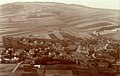
Holungen and the Sonnenstein around 1900

Bischofferode potash mine and the town of Holungen (1942) seen from the Sonnenstein

Overburden dump of the Bischofferode shaft in 2016 seen from the same point of view

Holungen and the Sonnenstein from the Hohenkammer perspective


panorama

nature
The treeless mountain top has a species-rich limestone lawn with various types of orchid, sun rose and Turkish lily, blue-grass limestone rock corridors. At the foot of the mountain you can find cotton grass and brook avens in the more humid grassland. An information board provides information about the special vegetation on the mountain.
literature
- H. Atzroth: The sun stone in history and legend. In: Eichsfelder Heimathefte 1st year (1961), Eichsfelddruck Heiligenstadt, p. 48ff
Individual evidence
- ↑ a b Map services of the Federal Agency for Nature Conservation ( information )
- ↑ Young woman falls from Skywalk on Sonnenstein in Eichsfeld. In: goettinger-tageblatt.de. March 3, 2019, accessed March 4, 2019.
- ↑ 19-year-olds fall from the “Skywalk” viewing platform. In: thueringer-allgemeine.de. March 3, 2019, accessed March 4, 2019.
- ↑ Levin von Wintzingeroda-Knorr : Die Wüstungen des Eichsfeldes: Directory of the desert areas, prehistoric ramparts, mines, courts of law and waiting areas within the districts of Duderstadt, Heiligenstadt, Mühlhausen and Worbis. O. Hendel, Göttingen 1903, pp. 490-493, 938
- ^ Paul Grimm and Wolfgang Timpel: The prehistoric and early historical fortifications of the Worbis district. In: Eichsfelder Heimathefte special edition, Worbis 1966, p. 54
- ↑ Levin von Wintzingeroda-Knorr : Die Wüstungen des Eichsfeldes: Directory of the desert areas, prehistoric ramparts, mines, courts of law and waiting areas within the districts of Duderstadt, Heiligenstadt, Mühlhausen and Worbis. O. Hendel, Göttingen 1903, p. 493
- ↑ Eds. Ulrich Harteisen, Ansgar Hoppe, Hansjörg Küster , Torsten W. Müller , Haik Thomas Porada , Gerold Wucherpfennig : Das Eichsfeld. Volume 79 of the series Landscapes in Germany. Verlag Böhlau , Vienna / Cologne / Weimar 2018, p. 247