Krantberg
| Krantberg | ||
|---|---|---|
|
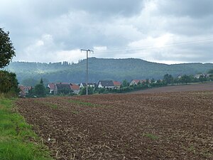
View over Gerode to the Krantberg |
||
| height | 455.8 m above sea level NHN | |
| location | Eichsfeld district , Thuringia ( Germany ) | |
| Mountains | Ohm Mountains | |
| Coordinates | 51 ° 30 '28 " N , 10 ° 24' 3" E | |
|
|
||
| rock |
Shell limestone , ( red sandstone ) |
|
The Krantberg (also Krautberg ) is 455.8 m above sea level. NHN high mountain in Eichsfeld in northern Thuringia .
location
The Krantberg is located in the northeastern part of the Eichsfeld district between the places Holungen in the south, Jützenbach in the northwest and Weißenborn-Lüderode with the district Gerode in the northeast, about 10 kilometers northeast of Worbis .
The state road L 1012 Worbis-Jützenbach leads west past the foot of the mountain.
Natural allocation
The Krantberg is also the namesake for the entire Muschelkalk ridge on the northern edge of the Ohm Mountains and is assigned as follows according to the natural spatial structure in the Halberstadt sheet :
- (to 37 Weser-Leine-Bergland )
- 374 Eichsfeld Basin
- 374.3 Duderstädter Bergland
- 374.32 Krantberg
- 374.3 Duderstädter Bergland
- 374 Eichsfeld Basin
The ridge located within the red sandstone landscape of the Bischofferoder Bergland belongs to the northern Ohmgebirgs graben zone , the Holunger Graben . Orographically, it can also be assigned to the Ohm Mountains. The main mountains of the rift zone are from north to south:
- Winkelberg (415.2 m)
- Krantberg
- Wehenberg (440.8 m)
- Sonnenstein (484.2 m)
The Thuringian State Institute for Environment and Geology uses a somewhat coarser own structure that only exists nationwide, within which the entire mountain ridge is included in the Ohmgebirge-Bleicheröder Berge unit .
particularities
Geologically, the Krantberg, like the entire mountain ridge, consists of middle shell limestone, with middle red sandstone on its western and eastern edge. The predominantly wooded (mixed beech forest) mountain consists of an eastern (455.8 m) and western knoll (444.8 m) and is accessible by several hiking trails, including the Harz - Eichsfeld - Thuringian Forest long-distance hiking trail . It is part of the Elbe-Weser watershed and headwaters of some small streams, including the salt well and the Jütze , a tributary of the Geroder Eller .
Individual evidence
- ↑ Map services of the Federal Agency for Nature Conservation ( information )
- ↑ J. Spönemann: Geographical land survey: The natural spatial units on sheet 100 Halberstadt - Federal Institute for Regional Studies, Bad Godesberg 1970 → online map
- ↑ Hydrogeological map of Thuringia from the Thuringian State Institute for Environment and Geology (PDF; 4.37 MB) ( Even finer maps are available for each district .)
-
^ Walter Hiekel, Frank Fritzlar, Andreas Nöllert and Werner Westhus: The natural spaces of Thuringia . Ed .: Thuringian State Institute for Environment and Geology (TLUG), Thuringian Ministry for Agriculture, Nature Conservation and Environment . 2004, ISSN 0863-2448 . → Natural area map of Thuringia (TLUG) - PDF; 260 kB → Maps by district (TLUG)

