Riethgraben (Wipper)
|
Riethgraben Riedgraben |
||
|
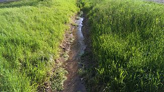
The Riethgraben near Wollersleben |
||
| Data | ||
| location | City and rural community Bleicherode , Nordhausen district , Thuringia , Germany | |
| River system | Elbe | |
| Drain over | Wipper → Unstrut → Saale → Elbe → North Sea | |
| source | at Nohra 51 ° 26 ′ 8 " N , 10 ° 42 ′ 2" E |
|
| Source height | approx. 209 m above sea level NN | |
| muzzle | near Wollersleben in the Wipper coordinates: 51 ° 26 '12 " N , 10 ° 43' 9" E 51 ° 26 '12 " N , 10 ° 43' 9" E |
|
| Mouth height | approx. 206 m above sea level NN | |
| Height difference | approx. 3 m | |
| Bottom slope | approx. 2.3 ‰ | |
| length | approx. 1.3 km | |
| Left tributaries | no | |
| Right tributaries | four nameless drainage ditches from Nohra | |
| Small towns | Bleicherode | |
|
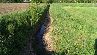
The Riethgraben near Wollersleben |
||
The Riethgraben is a short right tributary of the Wipper between Nohra and Wollersleben in the area of the urban and rural community Bleicherode in the district of Nordhausen in Thuringia (Germany).
course
The Riethgraben rises on the northern edge of the village soft landscape of Nohra itself and flows from here to the east, almost entirely along dirt roads. It is straightened, accompanied in sections by a perennial gallery, but mostly free of woody vegetation. Opposite the southern edge of Wollersleben, it joins the Wipper next to the L 2080 after 1.3 km from the right.
Flora and fauna
Various fish species occasionally migrate upstream from the Wipper into the Riethgraben, but none of the larger ones because the water in the ditch is only low. Duckweed cover sections of the small flowing water with little flow, the mean bed slope of which is less than 3 ‰.
Web links
Individual evidence
- ↑ Map from Google Earth

