Nohra (Bleicherode)
|
Nohra
City and rural community of Bleicherode
|
|
|---|---|
| Coordinates: 51 ° 25 ′ 59 ″ N , 10 ° 41 ′ 59 ″ E | |
| Height : | 212 m |
| Area : | 16.21 km² |
| Residents : | 811 (December 31, 2017) |
| Population density : | 50 inhabitants / km² |
| Incorporation : | 1st January 2019 |
| Postal code : | 99735 |
| Area code : | 036334 |
Nohra is a district of the city and rural community of Bleicherode in the Nordhausen district in Thuringia .
geography
location
Nohra is located in the valley of the Wipper on the district road 13, which leads to the nearby new federal highway 38 and to the stops of the railway line Wolkramshausen after the Eichsfeld . The Hainleite is to the southwest . At the northern development boundary, the Mühlgraben flows into the Wipper.
Distances
| direction | distance | target |
|---|---|---|
| North | 15 km | Harz - southern foothills |
| East | 20 km | Kyffhäuser low mountain range |
| Southern | 3 km | Hainleite ridge |
| West | 10 km | Bleicheröder Mountains |
history
Nohra was first mentioned on January 9, 1152.
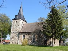
The hall church was built in the 13th century.
On July 1, 1950, the previously independent communities of Mörbach and Wollersleben were incorporated.
520 inhabitants live in the core town of Nohra.
On January 1, 2019, the communities of Nohra, Friedrichsthal , Kleinbodungen , Kraja , Hainrode , Etzelsrode , Wipperdorf and Wolkramshausen as well as the city of Bleicherode merged to form the new city and rural community of Bleicherode. The community of Nohra belonged to the administrative community Hainleite . In addition to the eponymous town of Nohra, the municipality also included the incorporated districts of Wollersleben , Mörbach , Hünstein and Kinderode .
politics
Municipal council
The community council in Nohra last consisted of eight council members:
|
Allocation of seats by the municipal council in 2014
A total of 12 seats
|
|||||||||||||||||
| Parties and constituencies | 2014 | 2009 | 2004 | 1999 | 1994 |
Local election 2014
Wbt .: 59.6% (2009: 50.9%)
% 60 50 40 30th 20th 10
0
53.1%
(+ 4.1 % p ) 20.9%
(-28.1 % p ) 26.0%
(+ 7.7 % p ) 2009
2014
|
|||||||||||
|---|---|---|---|---|---|---|---|---|---|---|---|---|---|---|---|---|---|
| Share a | Seats | Share a | Seats | Share a | Seats | Share a | Seats | Share a | Seats | ||||||||
| Christian Democratic Union of Germany | CDU | 20.9 | 1 ??? | 32.7 | 3 | 40.6 | 3 | 51.8 | 7th | 21.2 | 6th | ||||||
| Civic community | BG | 53.1 | 5 ??? | 49.0 | 4th | 40.9 | 3 | 37.4 | 4th | 60.6 | 7th | ||||||
| FFW Wollersleben f | FFW | 26.0 | 2 ??? | 18.3 | 1 | 18.5 | 2 | 10.8 | 1 | 18.1 | 2 | ||||||
| percentage of invalid votes | 5.3 | 4.0 | 5.6 | 6.9 | 8.1 | ||||||||||||
| Total seats | 8th | 8th | 8th | 12 | 12 | ||||||||||||
| voter turnout | 59.6% | 50.9% | 52.1% | 80.5% | 82.5% | ||||||||||||
|
a percentage of the valid votes cast
f 2009, 1999, 1994 as: Volunteer Fire Brigade Wollersleben
|
|||||||||||||||||
Economy and Infrastructure
Transport links
Nohra is on the Halle – Hann railway line. Münden ( stop Nohra (Wipper) ) and the Südharzautobahn A 38 . Erfurt Airport, 75 km away, is the closest commercial airport.
education
There is a “Zwergenstübchen” kindergarten and the Nohra State Elementary School.
Web links
Individual evidence
- ^ Wolfgang Kahl: First mention of Thuringian towns and villages. A manual. Rockstuhl Verlag, Bad Langensalza 2010, ISBN 978-3-86777-202-0 , p. 202.
- ↑ a b municipal council elections 2014. In: wahlen.thueringen.de. Retrieved March 27, 2019 .
- ↑ a b municipal council elections 2009. In: wahlen.thueringen.de. Retrieved March 27, 2019 .
- ↑ Local council elections 2004. In: wahlen.thueringen.de. Retrieved March 27, 2019 .
- ↑ Municipal council elections 1999. In: wahlen.thueringen.de. Retrieved March 27, 2019 .
- ↑ Municipal council elections 1999. In: wahlen.thueringen.de. Retrieved March 27, 2019 .


