Administrative community Hainleite
| coat of arms | Germany map | |
|---|---|---|
 Help on coat of arms |
Coordinates: 51 ° 25 ' N , 10 ° 42' E |
|
| Basic data (as of 2019) | ||
| Existing period: | 1991-2019 | |
| State : | Thuringia | |
| County : | Nordhausen | |
| Area : | 90.6 km 2 | |
| Residents: | 5438 (Dec. 31, 2017) | |
| Population density : | 60 inhabitants per km 2 | |
| License plate : | NDH | |
| Association key : | 16 0 62 5004 | |
| Association structure: | 6 municipalities | |
| Association administration address : |
Backsüber 3 99735 Wolkramshausen |
|
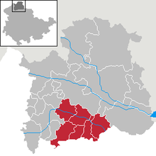
The administrative community Hainleite consisted of six communities. Its administrative seat was in Wolkramshausen . The last chairman of the administrative community was Uta Altenburg.
location
The administrative community Hainleite was in the district of Nordhausen in Northern Thuringia . It pulled itself along the Wipper and the Hainleite ridge , which gave it its name. Good transport links were provided by the A38 and the Leinefelde - Nordhausen railway line .
The municipalities
history
The administrative community was founded on August 1, 1991. On November 6, 1993, Großlohra, Kleinfurra and Wipperdorf joined the administrative community. As part of the Thuringia regional reform in 2018 and 2019 , the administrative community was dissolved on January 1, 2019. Hainrode, Nohra, Wipperdorf and Wolkramshausen merged with other communities to form the city and rural community of Bleicherode . For the other member communities, Bleicherode became the fulfilling community.
Population development
Development of the population:
|
|
|
|
- Data source: from 1994 Thuringian State Office for Statistics - values from December 31st
Individual evidence
- ↑ Thuringian Law and Ordinance Gazette No. 14/2018 p. 795 ff. , Accessed on January 22, 2019

