
Wollersleben
|
Wollersleben
Rural community town of Bleicherode
Coordinates: 51 ° 26 ′ 18 ″ N , 10 ° 43 ′ 13 ″ E
|
||
|---|---|---|
| Height : | 211 m above sea level NN | |
| Incorporation : | 1st January 2019 | |
| Postal code : | 99735 | |
| Area code : | 036334 | |
Location of Wollersleben in Thuringia |
||
 St. Juliane Church in Wollersleben
|
||

Wollersleben is a district (locality) of the rural municipality of Bleicherode in the Nordhausen district in Thuringia .
location

Wollersleben is to the west in the immediate vicinity of the Wolkramshausen train station . Around the place is the arable land in undulating terrain . The main road in 2080 leads through the district. The federal motorway 38 runs to the northwest .
history
In 1253 the first documentary mention of Wollersleben was registered in the document book of Walkenried Monastery I 312.
From 1950 to December 31, 2018, Wollersleben was part of Nohra and belonged to the Hainleite administrative community .
In addition to the name-giving place Nohra, the municipality also included the incorporated districts of Wollersleben, Mörbach , Hünstein and Kinderode .
On January 1, 2019, the communities of Nohra with Kinderode, Hünstein, Mörbach and Wollersleben, Friedrichsthal , Kleinbodungen , Kraja , Hainrode , Etzelsrode , Wipperdorf and Wolkramshausen with Wernrode and the city of Bleicherode with Obergebra and Elende merged to form the new town and rural community of Bleicherode.
Waters
Wollersleben is on the left bank of the Wipper . In addition, the small rinsing ditch flows through the village from north to south.
Pictures of the waters in Wollersleben:

Wipper in Wollersleben
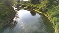
Wipper in Wollersleben

Rinsing ditch in Wollersleben
_in_Wollersleben.jpg)


Buildings
- St. Juliana , Protestant village church from the 17th century
Individual evidence
- ^ Wolfgang Kahl : First mention of Thuringian towns and villages. A manual. Rockstuhl Verlag, Bad Langensalza 2010, ISBN 978-3-86777-202-0 , p. 184.
Web links

Bleicherode | Flats | Wretched | Etzelsrode | Friedrichsthal | Gratzungen | Hainrode | Hünstein | Children's code | Small floors | Koenigsthal | Kraja | Mitteldorf | Mörbach | Nohra | Oberdorf | Obergebra | Pustleben | Wernrode | Wipperdorf | Wollersleben | Wolkramshausen