
Etzelsrode
|
Etzelsrode
City and rural community of Bleicherode
Coordinates: 51 ° 30 ′ 21 ″ N , 10 ° 36 ′ 37 ″ E
|
||
|---|---|---|
| Height : | 222 m | |
| Area : | 3.56 km² | |
| Residents : | 88 (December 31, 2017) | |
| Population density : | 25 inhabitants / km² | |
| Incorporation : | 1st January 2019 | |
| Postal code : | 99735 | |
| Area code : | 036337 | |
Location of Etzelsrode in Thuringia |
||
 Village center with village community center and former school
|
||

Etzelsrode is a district of the city and rural community of Bleicherode in the Thuringian district of Nordhausen .
Political community
Municipal area changes
On January 1, 2019, the municipalities of Etzelsrode, Friedrichsthal , Kleinbodungen , Kraja , Hainrode , Nohra , Wipperdorf and Wolkramshausen as well as the city of Bleicherode merged to form the new city and rural municipality of Bleicherode. Bleicherode was already a fulfilling municipality for the municipality of Etzelsrode.
Population development
Development of the population (December 31) :
|
|
|
|
|
Data source from 1994: Thuringian State Office for Statistics
Municipal council
The local council in Etzelsrode last consisted of six council members who were elected in the local elections on June 7, 2009 in a majority vote.
geography

Location and neighboring communities
Etzelsrode is located in the northern part of the Nordhausen district, about 6.5 km from the former inner-German border to the north. The village is traversed by the Rodebach valley , which joins the Bliedebach from Friedrichsthal about 1500 m to the northeast , and flows into the Helme after another 1100 m . The village is surrounded by the mountains Martberg (249 m above sea level) in the north, Etzelsroder Berg (247 m above sea level) in the east, Strutberg (249 m above sea level) in the south and the hill towards Friedrichsthal called Gratzunger Berg and Schweinsberg (about 240–250 m above sea level). The K 7 runs through the village from Friedrichsthal to Pützlingen . Etzelsrode is surrounded by agricultural land.
The most recent neighboring communities were Friedrichsthal and Werther .

history
Local foundation

A certificate from Emperor Otto from 977 shows that Archbishop Adalbert von Magdeburg had forests cleared on the upper Helme and the Ichte . Etzelsrode could have been created here. Presumably, other villages in the area were founded during this time, such as B. Mackenrode , Günzerode , Limlingerode , Liebenrode , Mauderode and Immenrode . So far, however, there is no evidence of this. ( See also -roda )
The village belonged to the County of Klettenberg from the beginning of the 11th century until 1256 , after which it was taken over by the new lords, the Counts of Hohnstein . With the death of Ernst VII in 1593, the ruling House of Hohnstein in the Harz region went out and Etzelsrode was to come to the legal successor, who, however, first had to be “determined”. After the end of the German Peasants' War , Count von Klettenberg held court at the Schiedunger Teich: every insurgent had to pay 4 guilders atonement to the court treasury in Ellrich . However, it is not known whether Etzelsröder farmers were involved in the peasant uprising. With the extinction of the Hohnstein noble family in 1593, the county was divided. Etzelsrode, which was part of the Klettenberg church supervision, fell to the Walkenried monastery . 1599 also Etzelsrode had a squad followed. The 6th Clettenberger Fähnlein was led by compatriot Hans Heinrich von Watteroth as captain ; the soldiers from Etzelsrode also belonged to him. Each house had to provide a man fit for military service or a substitute; those who stayed behind had to bear the costs. The village mayor managed the village team, in turn, a Corporal in charge of the exercise supervision. The village association consisted of riflemen , musketeers , halberd-bearers and philistines . In addition, forks, binding axes, morning stars , crossbows and side guns were used as weapons . The Etzelsröder team was composed as follows:
- Mayor: Caspar Ludwig
- Rottmeister: Daniel Merx and Balthasar Müller
- Shooters: Hans Kallmeyer, Heinrich Ostermann, Ludwig Wenkel, Hans Merx, Hans Baumgarten, Valentin Wenkel, Peter Ostermann, Andreas Rudolff, C. Höfer, Caspar Onekam, Caspar Wenkel and Jürg Steinkam
- Halberds: Hans, Dietrich and Heinrich Wenkel and Hans Sievert.

The Wenkel family gave the 245.7 m high Wenke (l) berg in the south of the village its name. At the beginning of the Thirty Years War , the village was largely spared: It was located off the military roads and had neither a knight's seat, a monastery nor an estate that would have promised tribute. In 1624 the village had 20 farmsteads, which were now listed for the first time with house numbers, with five properties being designated as Hintersiedler properties and one as half- span . The initial luck did not last for the village: in 1647 two-thirds of it was devastated, whereby a former farmhand who knew the place was particularly “proven” during the looting. A document in the Magdeburg State Archives shows only five fully managed properties (Heinrich Meyer, Paul Eisfeld, Andreas Siefert, Heinrich Gödecke and Jochen Müller), eight properties are mostly desolate. There were only 6 horses, 15 cows, 10 cattle, 22 pigs, 107 sheep and 4 goats left. The Peace of Westphalia caused Etzelsrode to become a Brandenburg-Prussian area. In 1681 the village was ravaged by the plague, in 1692 there was a great flood. In 1696, a government decree in Ellrich meant that newlyweds had to plant twelve trees. Many gardens and the Schänkeberg were planted with trees. The village chronicle mentions some events for the period from 1700 to 1938 that are insignificant from today's perspective and perhaps only of interest to local researchers. The chronicle ends in the winter of 1938/39.

origin of the name
The name suggests that someone named Etzel ( Attila ?) Cleared a piece of forest here in order to found the village. Perhaps the interpretation of the field name Etzelsbach of the place Etzelsbach , which could be derived from the Old High German name for Elster - agaza , can be applied to Etzelsrode. It is also possible that the site originally Etzenrode was called, because after records of Nordhäuser local historian Hans silver Borth gave away in 1104 Archbishop Ruthard an altar that was built with 5 hooves country to Etzenrode.
Earlier settlement
The village was originally settled along the Rodebach, which, together with the numerous springs in the creek's catchment area, used to carry considerably more water than it does today, as the Gratzunger and Etzelsröder Berg and Strutberg hills were still overgrown with bush and forest. Occasionally there were floods, so that the floods penetrated the “village street”, which is only a little above the level of the stream, and through the gardens and probably also into the houses, especially in the lower, western part of the village. Today, the buildings are higher up, because in the past they did not excavate, but instead built the new building on the leveled (rubble) plot of a previous building. For example, when digging a slurry pit in 1936, a paved path was found in the garden at “Hof Nr. 5” at a depth of 1 m. There was no village street in today's sense. From the west end a dam led along the right row of houses to the rectory, which was accessible until then. Then the Rodebach had to be crossed in a wide ford (today there is a wide bridge). In the direction of the eastern exit of the village, the path narrowed so that a car could just fit through. The road was widened several times (around 1830, 1865 and 1884) in order to meet traffic requirements. The houses across the dam were also accessible by fords. Only later, until 1909, were wooden and later concrete bridges built.
Each homestead had an associated piece of land behind the property, which was roughly the width of the property. Forest and parts of the pasture were used jointly, part of the meadows was the property of the lordly owners. However, after the hay had been harvested, i.e. after Michaelmas Day at the end of September, the farmers were allowed to drive their cattle to these meadows together. The farms of Klettenberg Castle , Gut Schiedungen and Gut Bliedungen also had the right to herd their sheep at certain times here and also on the owners' meadows. The meadows in Unkental were spared until Pentecost , until Jacobite Day (July 25th) they were only allowed to be used by the 14 landowners and the pastor, and later until autumn by all those authorized to guard them, including those from Bliedungen and divisions. That was regulated in the contracts on service and interest . The village with the first 15 farmsteads was surrounded by a path that is still largely the same today. The K 7, which is tangent in the west, was also the western part back then. A dirt road branches off from the K 7 in the northwest of the village and runs behind the gardens in an arc to the east, where it meets (previously crossed) just before the end of today's village road. Then he crossed or crossed the stream behind the property, which is opposite the current confluence of the path in the village street. After that, it continued on the field path that now runs south to about 100 m before the current confluence with the K 7. Finally, it made a bend to the northwest and after about 180 m formed the western edge of the village (today's K 7), around 200 m m to return to the starting point. So you can still follow this path almost completely today.
A tavern for the village is already documented around 1581. It was on the Anger , the triangular square that was lined with pear trees. Today this area is built on in the southwest corner of the village. Bars were previously set up outside the village on a passageway so that the traveling people didn't get too far into the village. The tavern usually had a forge. As a blacksmith, the innkeeper was able to earn additional money from the horses and wagons of the passing guests. The manufacture of tools and weapons was part of the profession. In addition, the blacksmiths were naturally strong men who kept the hostel running and were able to offer protection to honorable guests. After 1750, the innkeeper, master blacksmith and armorer Johann Elias Buchmann built a half-timbered tavern "Zum Stern", which even had a hall on the upper floor. Just four years later, Buchmann died at the age of 52 and, among other things, left a loan of 100 thalers that he had taken out to build the house and which the community has now repaid. The community now took over the property and from then on leased the tavern. The next tenant also died after four years in 1759 at the age of 39. After the Seven Years' War the community had to sell the tavern to pay off its debts. On July 1, 1939, the concession for the inn, which had been in operation for over 200 years, was returned.
Today's settlement
Today the village is to be seen as a street village , which however has some “vacant lots” along the road. The plots north of the stream are accessible via small but passable bridges, and the plots can be reached "from behind" using the route described. The first of these bridges was built in 1799. The apparently largest vacant lot is today's playground / sports field next to the schoolhouse and church that was newly built in 1911.
Paths and corridors - then and now
In addition to the “bypass” already described, there are other ways to be mentioned that already existed in historical times:
- Kehmstedter Weg: Today it runs from the southwest corner of the village in a largely straight direction to the neighboring town of Kehmstedt, 3,500 m away . It passes east of the Gratzunger Berg , comes near the Rodebach spring, leaves the Ziegenberg (this is where the goats used to be tended) to the west and reaches the Silbertal (formerly Silberbirkental , the birches were felled in 1621 to gain arable land). Then it leads past the Hühnerberg (in the east) and crosses the top of the Kirchberg about 500 m before reaching the destination, whereby the last few meters lead steeply downhill, directly towards the church. The path used to be about 50 m to the east and led through the Rodebach Gorge.
- Haferunger Weg: Today it runs from the southeast corner of the village in an easterly direction to the neighboring village of Haferungen, 3,250 m away . It climbs slightly uphill on the southern flank of the bast wood on the Martberg (formerly Marktberg ), makes a bend to the south on the Etzelsroder Berg and a bend to the east on the Immenroder Trift and reaches the Haferunger Flur.
- From the east exit of the village to Bastholz , a footpath led past Asgraben (formerly Ostgraben ) (up to this point identical to Haferunger Weg) to Haferunger Stein , a stone cross near the boundary to Haferungen. The roadside was once lined with thick hazelnut bushes. From here the path continues in an almost straight direction to the east and reaches the neighboring village of Haferungen at the cemetery.
- Gratzunger Weg: Today it forms the K 7 to Friedrichsthal-Gratzungen .
- The Pützlinger Weg: The way to Pützlingen used to be a little west of today's K 7 and formed the extension of the Kehmstedter Weg leading to the north.
- In the past, a footpath ran from the west exit of the village across the field towards Gratzunger Weg.
Old field names
Strutberg, Ziegenberg, Krumme Äcker, Sautal, Wachtberg, Bruch, Schaufel, Marktberg, Haselgarten, Söttlingswiese, community garden, Lehmkuhle, behind the Haselhof, Breitel, Pützlinger Rodelandsberg → Rolandsberg, Bastholz
Culture and sights
Village church
Construction and history

The Evangelical Trinity Church (Jödecke, p. 75) was built from strong limestone masonry in 1718 during the tenure of pastor Mag. Johann Andreas Weber. It was built in place of a dilapidated and dilapidated predecessor that was damaged in the Thirty Years' War and was probably demolished after 1664. The nave is provided with three simple arched windows on the north and south sides and one on the east side. On the north side is the relatively low, beautifully designed, wooden entrance door. The tower entrance is also on the north side. The approximately 30 m high church tower was built on the west side of the nave in 1876 after the "small tower" had become too low and too narrow for the bells and clockwork. The pointed tower is clad and covered with slate all around from the first floor. The top bears a tower ball (probably around 1876) and an iron weather vane . The church clock can be found on the north side. There is a window on the south side of the first tower floor. The bell rings on the floor above. Their sound goes through sound openings in all directions. The ground floor of the tower serves as a storage room, in which, for example, two old coffin goats are placed. The nave has a gable roof with red tiles and is shaped on the east side as a crooked hip roof over a trapezoidal gable . A gable dormer with a protruding roof was installed on both sides of the roof .
The interior of the nave is spanned by a gallery. On the long sides (north and south) there were once the men's chairs, while the women sat below. According to old custom, every piece of land in the village was entitled to a church chair. The organ is housed on the narrow western part, opposite the altar and pulpit on the eastern side.
Gottlieb Knauf's organ
Because of a sign with the inscription " Rudolf Böhm, Orgelbauanstalt " it was assumed for a long time that this was the builder of the organ. It is correct that the parish had signed an organ maintenance contract with Böhm in Gotha. The company is out of the question as a builder, as it did not appear until 1888. In fact, the organ, which can no longer be played today, was built in 1843 by Gottlieb Knauf , who belonged to an important Thuringian organ building dynasty and founded his workshop in Bleicherode at today's Löwentorstraße 14 in 1838 .
The organ was built during the term of office of the teacher and cantor Karl Kößler, who, according to the school chronicle, held this office from 1819 to 1861. Since he was not only known as a committed teacher, but also had the reputation of a passionate organist and popular choir director, it is reasonable to assume that a predecessor of today's organ must have been available before 1843. The great importance Kößler attached to the new instrument is evidenced by the lettering he left on the inside of the case. The historical records do not provide any information about the exact time of completion, nor about when and in what context the organ consecration took place.
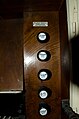
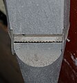
The instrument, which was designed for use in worship, is a mechanical slide organ , a construction that was already established during the Baroque period. It has a manual, range C - c '' 'and a pedal, range C - c'. Manual and pedal drawer are made of oak, as are the loops and valves. The mechanical parts consist mainly of spruce wood. Black wooden buttons with white porcelain plates with the respective register designation are attached to the registers. The wind is generated by a two-fold magazine bellows, which in turn is supplied with the help of a hand-operated scoop bellows.
Disposition
| manual | pedal | Side trains |
|---|---|---|
| Principal 4 ' (Cb' 'in the brochure, cores engraved, made of zinc sheet) | Violonbass 8 ' (made of wood) | Pedal coupler |
| Gedackt 8 ' (made of wood) | Subbass 16 ' (made of wood) | |
| Gedackt 4 ' (made of wood) | ||
| Mixture 3-fold / 1 ' (made of tin) | ||
| Flute traversa 8 ' (C - B covered, high octave partly conical, made of wood) | ||
| Hollow flute 8 ' (C - H covered, made of wood) | ||
| Octave 2 ' (made of pewter) |
The placement of the pedal whistles is chromatic. The manual drawer follows the diatonic principle with the C and C sharp sides. This is reflected in the organ prospectus , which bears the entire Principal 4 'apart from the two tallest pipes standing directly on the drawer. In general, all registers have a rather slim scale . The overall sound was correspondingly bright. Two manual registers, which are basically open, hollow flute and flute traversa, had to be covered in the first octave , as there is no space for an expanded 8 'register in terms of the height. The pipes are only made open from the second octave. However, through skillful intonation it was possible to avoid too large a break in the sound. The low cut height of the pipes suggests that the organ could work with a relatively low wind pressure of around 50 - 60 mm WS, which would be appropriate for the size of the church interior. However, the acoustics in the church deteriorated significantly due to the new cladding of the vault with chipboard. The intonation may therefore have to be adapted to the new conditions, but this cannot be determined due to the unplayability. The flat, classicist prospect is simply designed and is reminiscent of a Greek temple. There are only a few decorations, such as the two snakes and the central flower ornament in the pediment as well as the diamond motifs on the removable wind chests. Both can be interpreted as symbols for infinity or, if you will, for immortality. The three pipe fields are covered with simple, wave-shaped veil boards.
In 2018 the Knauf organ in Etzelsrode was 175 years old. Despite the disgusting standing conditions for the instrument over the decades, a great deal of useful, elementary substance has been preserved. That alone justifies a restoration or at least a repair that is appropriate to the monument.
- Views of the current state of the Knauf organ

Organ prospectus

manual

Register mechanism

Wave board

Valve box
Register, right side

Lettering from Kößler
Principal 4 'with core stitches

Pipework


Trinity Church bells
According to the text " Descriptive representation of the older architectural and art monuments of the Grafschaft Hohenstein district ", the casting of the first Etzelsröder bell can be dated to the beginning of the 14th century. The inscription read: “SANTA MARIA. SANTE NICOLA. SANTE PETRE. SANTE PAULE. SANTE IHOHANNE. ”, Adding the implicit request“ ORATE PRO NOBIS - Pray for us ”. When the second bell with the inscription " O REX GLORIE XPE VENI CUM PACE " was added, the script does not provide any information.
Due to the inharmonious sounding of the bells and an inscription that was reversed and only superficially incised, the Dreieinigkeitsgemeinde acquired two new bells from the then world-famous bell foundry in Apolda in 1897 . The old bells could be given in payment. It is not known whether their material was reused for the new bells. The bell festival took place in the fall of 1897. For the new bells, 340 kg and 166 kg in weight, 1,012 marks had to be raised. One of the inscriptions read: "Blessed are those who hear and keep God's word." Initially, both bells were connected to the striking mechanism of the tower clock. In 1905 two separate bells, made by a Bleicheröder workshop, were attached above the clock face on the north side of the tower under a small dormer. The community invested 537 marks for this.
The bells of the chimes installed in 1897 fell victim to the two world wars: the smaller bell had to be made available to the German Empire as molten metal during the First World War. On February 22nd, 1942, World War II called for the big bell to be used to make weapons and ammunition. Two years earlier, on April 6, 1940, the sacrament utensils and the candlestick had to be handed in on the occasion of a metal collection for war purposes.
The bell that rings today dates from 1931. It is dedicated to the Etzelsröder fallen soldiers of the First World War and bears their names as an inscription. The consecration of bells took place on December 20, 1931 (4th Advent). On the first day of the fair in 1931, the then cantor Erdmann and the incumbent pastor Matthias organized a collection for this purpose, which ultimately brought in 366 Reichsmarks.
Also with this bell there must have been an error during the casting preparations. The year " 1931 " was inserted incorrectly, namely " 1913 ". After completion, an attempt was made to correct the error by grinding. You can still see the outline of the incorrectly placed " 1 " and the inappropriate spacing of the characters. There is still no replacement for the big bell that was lost in World War II.

Bell from 1931
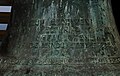
Bell from 1931 - detail

The bell of the tower clock from 1905


Pictures from the church

Entrance to the nave

Choir side with altar and gallery pulpit

Painting by an unknown master

Painting by an unknown master

Organ loft

Church organ by Gottlieb Knauf, Bleicherode

Clock tower


graveyard
Formerly, until 1846, the cemetery was laid out around the church. The community then bought a new cemetery site in the south of the village ( An der Trift ) and built a small burial house on it. When the cemetery became too small again in 1888, the already damaged building was demolished and more graves were laid there. The community then bought more land below. This cemetery area was given up in 1929 in favor of a new cemetery to the west of it. The current cemetery is southwest of the aforementioned.
Further information
- The parish Etzelsrode belongs with the parishes Friedrichsthal, Pützlingen and Schiedungen to the parish Etzelsrode, which in turn belongs to the parish Trebra of the Evangelical Church in Central Germany .
- In the north of the church is the former school . Today the beautiful half-timbered building is used by the parish. There is an apartment on the first floor.
- The next building on the street to the east is the former rectory. In between is the village community center, which was built in GDR times as Kónsum , a sales point of the then well-known retail chain . Today the building serves as a central meeting and event location and is also the domicile of the Etzelsrode Heimatverein.
Local dialect
The northern Thuringian dialect was extremely lively in Etzelsrode until the early nineties of the last century. In the period that followed, however, this significant characteristic of Etzelsröder's local color faded more and more and is now only preserved in rudimentary form in the intonation of everyday language and in a few remaining words of dialect origin. The reasons for this development are certainly complex. In addition to a de facto no longer existing infrastructure, one of the main causes is that the serious political changes have almost extinguished common everyday life, which in times of transition was mainly characterized by work in farms that no longer exist today. Thus, the local language has necessarily been reduced to a universal standard.
There are hardly any writings from Etzelsrode that document the regional dialect, with one exception: In the winter of 1879/80, the Marburg linguist Dr. Georg Wenker registration sheets, the Wenker sheets, to the communities of the former Grafschaft Hohenstein in order to record the dialects spoken there, to analyze them and to integrate them into his "German Language Atlas". These sheets were mainly worked on by the local village school teachers, in Etzelsrode by Albin Stange. They contained 40 standard-language sentences, the Wenker sentences, which had to be translated into the local dialect by the editor, based on linguistic criteria that were specifically relevant for northern and central Germany. The Wenkerbogen for Etzelsrode No. 06,446th in German cursive received. It also gives a little indication of what clothes - especially by the men - were worn in Etzelsrode at the time of the recording.
Sound documents of the Etzelsröder dialect do not exist. Only two images from the region have been recorded: one from Pützlingen (1964), recorded by the Thuringian Dialect Research Unit, and one from Großwechselungen (1991), recorded by the Research Center German Language Atlas.
Web links
Individual evidence
- ↑ a b c d e f g h i j k l m n o p Karl August Jödecke: Ortschronik von Etzelsrode, 1938/39, storage location: Municipal administration Etzelsrode
- ↑ Rep. A. 17a Land estates of the County of Hohenstein Rep. AL Xo Page 121 concerns the state visitation of the Clettenberg office from June 30 to July 13, 1647
- ^ Organ database. Accessed December 31, 2018 (multilingual).
- ↑ Etzelsröder school chronicle (privately owned, copy at the municipal administration)
- ↑ Descriptive representation of the older architectural and art monuments of the Grafschaft Hohenstein district Edited by Dr. Julius Schmidt Published by the Historical Commission of the Province of Saxony XII. Notebook. Retrieved March 3, 2019 .
- ^ Wenkerbogen - Research Center for the German Language Atlas. Retrieved October 28, 2018 .
- ^ DSA - Research Center for the German Language Atlas. Retrieved October 28, 2018 .
- ^ Wenkerbogen - Research Center for the German Language Atlas. Retrieved October 28, 2018 .
- ↑ SPEECH Wenkerbogen view. Retrieved October 28, 2018 .
- ^ Thuringian dictionary Jena: Sprachprobe Nordthüringisch. Retrieved October 28, 2018 .
- ^ Thuringian dictionary Jena: Thuringian dialect research. Retrieved October 28, 2018 .
- ↑ https://www.regionalssprache.de/Audio/AudioFileIntervalViewer.aspx?Id=702&AudioFileId=702. Retrieved October 28, 2018 .
- ^ Research Center for the German Language Atlas. Retrieved October 28, 2018 .

Bleicherode | Flats | Wretched | Etzelsrode | Friedrichsthal | Gratzungen | Hainrode | Hünstein | Children's code | Small floors | Koenigsthal | Kraja | Mitteldorf | Mörbach | Nohra | Oberdorf | Obergebra | Pustleben | Wernrode | Wipperdorf | Wollersleben | Wolkramshausen