Klettenberg (Hohenstein)
|
Klettenberg
Community Hohenstein
Coordinates: 51 ° 33 ′ 22 " N , 10 ° 35 ′ 38" E
|
||
|---|---|---|
| Height : | 240 m above sea level NN | |
| Residents : | 414 (Dec. 31, 2009) | |
| Incorporation : | October 18, 1996 | |
| Postal code : | 99755 | |
| Area code : | 036336 | |
|
Location of Klettenberg in Thuringia |
||
|
St. Nicolai Church in Klettenberg
|
||
Klettenberg (formerly Clettenberg ) is a district of Hohenstein in the district of Nordhausen am Harz in Thuringia .
geography
The federal road 243 leads south past the district of Klettenberg and the state road 2067 brushes the corridor east . The areas around Nordhausen and Göttingen are connected with the federal highway . The Mühlgraben flows through the village . The hills to the east behind Klettenberg were a suitable protection for nature and people in the Vorharz.
history
The first documentary mention of Klettenberg took place in 1187.
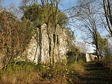
In 1078 the construction of the Klettenberg Castle began . This lay east on a spur-like limestone rock . It probably had the task of controlling and protecting the open area on the southern Harz. It also secured the Walkenried monastery and the north-south road. This is how the County of Klettenberg came into being , which was captured in 1256 after constant feuds with the Count of Hohnstein . The rock is now overgrown with scrub. There are still remains of the wall at the foot of the hill.
In Klettenberg (1923) there was a domain (338 ha) and a manor (179 ha).
Like all of Thuringia, the place was occupied by the US Army in April 1945 and passed on to the Red Army in early July . Klettenberg became part of the SBZ and, from 1949, the GDR . Until 1989 it was in the restricted area of the zone border and was the location of a garrison of the border troops of the NVA .
The once independent municipality of Klettenberg belonged to the Grenzland administrative community from 1991 to 1996 . With the dissolution of this on October 17, 1996, the member communities were merged to form the community of Hohenstein.
Attractions
- Church of St. Nicolai : The church was built as a castle chapel in 1647 and consecrated in 1706. The large, towerless building has a wooden barrel vault and a carved altar wall. On the east gable, outside the church, is the subterranean count's burial vault. Also because of its location in the restricted zone of the inner-German border, the church was abandoned in 1975 and designated as a ruin. After the Peaceful Revolution, the Monument Protection Office made the church one of its priorities and introduced the first security measures in 1990. In 1993 a support association was founded. The church was completely renovated and in 2005 it was again usable all year round through the installation of a community room.
- Manor house
- Ruins of Klettenberg Castle
Klettenberg is located on the southern Harz karst hiking trail
Personalities
- Johann Heinrich Michaelis (1668–1738), Protestant theologian and oriental philologist
- August Gottlieb Spangenberg (1704–1792), Protestant theologian and second founder of the Moravian Brethren Union
Individual evidence
- ↑ Klettenberg on the website of the Hohenstein community
- ^ Wolfgang Kahl : First mention of Thuringian towns and villages. A manual. Rockstuhl Verlag, Bad Langensalza, 2010, ISBN 978-3-86777-202-0 , p. 148
- ↑ Michael Köhler: Thuringian castles and fortified prehistoric and prehistoric living spaces Jenzig-Verlag 2001, ISBN 3-910141-43-9 , S160
- ^ Thomas Bienert: Medieval Castles in Thuringia Wartberg-Verlag, 2000, ISBN 3-86134-631-1 , p. 185
- ↑ Explanation board on the church door (2013)


