Holbach (Hohenstein)
|
Holbach
Community Hohenstein
Coordinates: 51 ° 32 ′ 26 ″ N , 10 ° 36 ′ 12 ″ E
|
||
|---|---|---|
| Height : | 216 m above sea level NN | |
| Residents : | 196 (2009) | |
| Incorporation : | October 18, 1996 | |
| Postal code : | 99755 | |
| Area code : | 036337 | |
|
Location of Holbach in Thuringia |
||
|
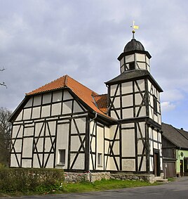
St. Bartholomew Church
|
||
Holbach is a district of the municipality of Hohenstein in the Nordhausen district in Thuringia .
geography
The village is south of Klettenberg . The federal road 243 ( Nordhausen - Herzberg am Harz ) runs through the village. At the western end of the village, the L 2064 branches off to the south, which after 1.5 km at Kuhberg (267.1 m above sea level) meets and ends with the L 1034 leading from Schiedungen to Hohenstein . The place is therefore well connected in terms of transport.
The district is docked and karstified and remote from the groundwater. The place is traversed by the Mühlgraben, which flows into the Ichte about 1100 m further south-east . The flood retention basin (HRB) Holbach is located on the northern edge of the village . The highest elevations in the area are the Mühlberg (245.2 m above sea level) in the north, the Schalksberg (254 m above sea level) in the west and the Ichteberg (250.3 m above sea level) in the south.
The Südharz nature park borders directly on the town, its southern border runs parallel to the B 243 and the path to Espenmühle.
history
The name Holbach is derived from the word Halebach . The stream was later called Helebach , today Mühlgraben . The name means the river flows in the cave , so it seeps into the karstified rock. At first there was only a vassal seat with servants' houses in the hamlet . In 1093 the village is called Holbikk or Holbik . The appellative -bik , like -bach, refers to the water flowing here.
Already in 1187 the place is called Holbach , 1193 Holebach and 1214 Holebac , as has been handed down in writing. While the village was simply called Hol in 1226 , the current name is used from 1322. The place probably originated from one or a few individual farmsteads before 1000. Without having any proof that the place already existed in 1093, the 900th anniversary was celebrated from June 4 to 6, 1993.
The baroque half-timbered church was built around 1745 using older buildings from the 13th century.
According to Wolfgang Kahl, it was first mentioned in a document on January 9, 1152.
The formerly independent community of Holbach belonged to the Grenzland administrative community from 1991 to 1996. With the dissolution of this on October 17, 1996, the member communities were merged to form the Hohenstein community.
Attractions
- The baroque St. Bartholomew Church with its tower was built in 1745 as a hall church. In 1994 she received a gold-plated ball with a cross. The hereditary burial of the owners of the former Klettenberg manor , the Lords of Zangen, is located in the church.
- The school building next to the church was built in 1794. In 1839 the classroom was enlarged. School lessons were held until 1950.
Individual evidence
- ↑ Holbach on the website of the community Hohenstein
- ↑ [1]
- ^ Wolfgang Kahl : First mention of Thuringian towns and villages. A manual. Verlag Rochstuhl, Bad Langensalza, 2010, ISBN 978-3-86777-202-0 , p. 127

