Ite
|
Ichte upper course: Steinaer Bach or Steina |
||
|
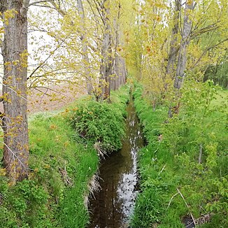
Course of the Ichte on the road from Schiedungen to Holbach |
||
| Data | ||
| Water code | DE : 564812 | |
| location | Harz and southern Harz foreland; Districts of Göttingen and Nordhausen ; Lower Saxony and Thuringia ( Germany ) | |
| River system | Elbe | |
| Drain over | Helme → Unstrut → Saale → Elbe → North Sea | |
| source | at the Jagdkopf east of the Oder dam 51 ° 39 ′ 19 ″ N , 10 ° 32 ′ 43 ″ E |
|
| Source height | approx. 670 m above sea level NHN | |
| muzzle | in the southern Harz foreland near Pützlingen in the Helme coordinates: 51 ° 31 '27 " N , 10 ° 37' 46" E 51 ° 31 '27 " N , 10 ° 37' 46" E |
|
| Mouth height | 198 m above sea level NHN | |
| Height difference | approx. 472 m | |
| Bottom slope | approx. 21 ‰ | |
| length | 22.3 km | |
| Catchment area | approx. 40.5 km² | |
| Left tributaries | Mill moat | |
| Right tributaries | Bach from Sülzensee | |
The Ichte , in the upper reaches of Steinaer Bach or just Steina , is a 22.3 km long, northwestern and orographically left tributary of the Helme in the south of the Harz in Lower Saxony and Thuringia . It is longer than the helmets above its mouth.
location
The source of the Steinaer Bach creek is located in the Lower Saxony district of Göttingen in the Harz Mountains between the catchment areas of the Oder in the west and the Wieda in the east, about two kilometers more south than the source of the Wieda. The Ichte flows into the Helme in the Harz foreland in Thuringia , ten kilometers west of Nordhausen . The name boundary between Steinaer Bach and Ichte lies at the mouth of the Hellegrundbach . It is significantly narrower than the Steinaer Bach, only about a sixth as long (2.1 compared to 11.8 km) and has only less than half of the catchment area (8.0 compared to 20.18 km²). Therefore it is only to be regarded as a lateral tributary and not as an equivalent spring water.
course
The Steinaer Bach rises one kilometer east of the Oder dam at almost 670 m above sea level on the southern slope of the Jagdkopf and then flows at about 620 m above sea level just 200 m east of the source of the Oder tributary, Große Herzbek . From there the Steina flows in the wooded Steinatal in a southerly and then in a southwestern direction. The valley runs northwest past the 660 meter high Ravensberg . A little later, the stream turns to the south-southeast and flows through the Steinatalsperre, which is only 1.7 hectares in size (approx. 375 m ). None of the lateral tributaries in the Harz is significantly more than 1000 m long. Shortly after the village of Steina , the stream reaches the edge of the Harz mountains. and is crossed there by the "Südharz route" Northeim – Nordhausen . At the bridge of the B 243 , the water flows south and leaves the Harz Nature Park .
After 11.8 km of flow path from the source at the Jagdkopf, the Steinaer Bach gets its second largest tributary from the right about 1 km south of the hamlet of Nüxei , the 2.1 km long Hellegrundbach from the Mackenröder forest near the Hohenstein district of Mackenrode . Its mouth is in the Steingrabental - Mackenröder Forest nature reserve . From here on the main body of water is called, still more of a stream than a river Ichte . Here the valley is bordered by the Lower Saxon Steinberg ( 274 m ) and beyond the state border the Thuringian Buchenberg ( 320.2 m ) in the west and Mackenrode in the southeast.
At the transition from the Harz to the southern Harz foreland (north and south of the Nüxeis), the flowing water is dry for most of the year. The reason for this is the karst subsoil of the region.
In Thuringia, in the Sülzensee - Mackenröder Forest , the Sülzensee drains into the Ichte.
Its confluence with the Helme lies at 198 m 600 m east-northeast of Pützlingen , a district of Werther . The Helm flows parallel to the southern edge of the Harz to the east and flows into the Unstrut .
Catchment area and tributaries
The catchment area of the Ichte measures a total of 40.5 km². Its tributaries include the Hellegrundbach and the Sülzensee creek, the largest of which is the Mühlgraben from Klettenberg.
Helmetalbahn
South along the gel density and through the valley of the helmets previously proceeded of Osterhagen according Nordhausen leading helmets Talbahn . The planned two-track railway line was built in 1944/45 by inmates of the Mittelbau-Dora concentration camp and completed as a single track, but was no longer in operation at the end of the Second World War in May 1945. It was then completely dismantled by 1947 due to its location on the inner-German border .
Web links
- Elbe area directory for the Lower Saxony hydrographic map (updated July 13, 2010), on Umwelt.niedersachsen.de (PDF; 224 kB)
Individual evidence
- ↑ a b c Hydrographic Map of Lower Saxony , Lower Saxony Ministry for the Environment, Energy and Climate Protection, on Umweltkarten-niedersachsen.de
- ↑ ulamm: GPS route Etzelsrode - Ichte - Steinaer Bach. In: gpsies.com. April 9, 2017. Retrieved April 12, 2017 .
- ↑ a b Lower Saxony environmental maps: water network with direction of flow, catchment areas, object information , for height determinations with DTK
