Ravensberg (Harz)
| Ravensberg | ||
|---|---|---|
|
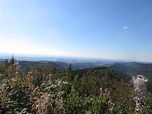
View from the Großer Knollen southeast to the Ravensberg |
||
| height | 659 m above sea level NHN | |
| location | near Bad Sachsa ; District of Göttingen , Lower Saxony , Germany | |
| Mountains | Harz (southern Harz) | |
| Dominance | 3.67 km → Jagdkopf am Stöberhai | |
| Coordinates | 51 ° 37 '17 " N , 10 ° 31' 37" E | |
|
|
||
| rock | Rhyolite | |

The Ravensberg in the Harz is about 659 m above sea level. NHN high mountain near Bad Sachsa in the non-parish Harz region of the Göttingen district in Lower Saxony .
Geographical location
The Ravensberg is located in the southern Harz in the Harz Nature Park . It rises about 3.5 km northwest of Bad Sachsa , about 4.5 km east of Bad Lauterberg and about 4.5 km (as the crow flies ) southwest of Wieda . To the west the mountain passes the Steina ( Steinaer Bach ), which then flows southwest of it through the Steinatalsperre to the Ichte .
The Uffe rises northeast of the summit and passes the mountain a little east in the Ostertal and flows into the Wieda , provided that it does not seep into the gypsum karst. In the Kukanstal (Kuckanstal) and Katzental , streams arise to the southwest and east of the mountain elevations , which shortly after their confluence feed the melt pond located southeast of the mountain in Bad Sachsa and shortly afterwards flow into the Uffe.
The mountain is relatively exposed and can be seen from afar.
Natural allocation and landscape protection
The Ravensberg belongs in the natural spatial main unit Middle Harz to the subunit Southern Middle Harz (380.80). It is located in the Harz landscape protection area (district of Göttingen) ( CDDA no. 321403; 2000 designated; 300.2 km² in size).
geology
The soaring cone is the remainder of an extinct volcano from the Permian Age , the main rock is rhyolite that is relatively slowly weathering .
Berghof Ravensberg
As early as 1845, some Sachsa residents, especially Mayor Scheidel, persuaded the farmer August Koolhaase to build a restaurant on the Ravensberg summit. In 1848 he built the first wooden refuge with a milk and beer bar.
In 1854 the first stone restaurant followed with a 13 m high observation tower, which afforded a view of the Stöberhai, Wurmberg , Brocken and Kyffhäuser . The restaurant was expanded in 1888 by a wooden upper floor and this was expanded with guest rooms. The Hotel Berghof Ravensberg has been rebuilt several times. In the style of a mountain chalet was dressed in a planking and resembled his porch and the observation tower the neighboring mountain hotel Stöberhai . The Berghof and its tower burned down completely on Christmas Eve 1962.
The family of the owner Fritz Kühn then rebuilt the hotel building that still exists today in a modified form, which was opened on March 11, 1964. A new observation tower was not built.
In September 2009, the Berghof was acquired by the City of Bad Sachsa and is therefore no longer family-owned for the first time.
The Berghof Ravensberg animal enclosure is located next to the Berghof .
Dreiherrenstein
Slightly below the Ravens Mountain summit is located on the Ravens mountain road a derived probably from the 17th century Dreiherrenstein until 1866 as part of an on the border triangle , the Kingdom of Prussia , the Kingdom of Hanover and the Duchy of Brunswick together marginalized.
On the small boundary stone, along with other marks, the original border information can be seen in the form of letters or Roman numerals: "S" for Sachsa on the Prussian side, "FG" for the Principality of Grubenhagen , "L" for Lauterberger Forst on the Hanover side and "W “For Walkenried Abbey on the Brunswick side.
Postal agency
In 1884, the postmaster general Heinrich von Stephan , who lived in the Berghof Ravensberg while on vacation and hunted in the area, set up a post office on the Ravensberg, which was closed in 1914.
Kyffhäuser memorial stone
The “Kyffhäuser Memorial Stone” with a metal plaque stands next to the Berghof Ravensberg on the Ravensberg summit. Their inscription refers to the "81 m" high and "46,000 m" east-southeast of the memorial stone between "1890" and "1896" erected " Kyffhäuser Monument " , which is located in the Kyffhäuserkreis in Thuringia in the Kyffhäuser Mountains. On the base of the memorial stone there are these letters: “Unity and Law and Freedom” .
Telecommunications tower
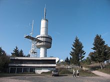
On the Ravens mountain is a 64 m high, former and known locally as the Ravens mountain tower called Enlightenment tower , which was built 1970th
The tower operated by the Federal Intelligence Service (BND) served as a radio monitoring system for listening to military radio traffic in the GDR during the Cold War .
Today, the remaining antenna systems are used by Deutsche Telekom as a radio transmission point (FuÜSt) .
leisure
Opportunities for viewing and hiking
The Ravensberg is a popular vantage point, whereby the view in the Harz extends to the Brocken , Großer Knollen and Stöberhai as well as to Bad Lauterberg and as far as Thuringia , for example to the Kyffhäuser Monument in the Kyffhäuser Mountains .
The Dreiherrenstein, located near the mountain top, is a popular passage point for hikes and mountain bike tours. Along with other forest and hiking trails, the Harzer Baudensteig leads over the mountain .
Winter sports area
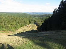
The winter sports area on the Ravensberg is equipped with a double T-bar lift (298 m long; 103 m difference in altitude) and two single T-bar lifts (140 and 186 m long; 33 and 55 m altitude difference) and nine ski slopes with a total of over 4 km in length; the longest run is 750 m and the shortest 220 m. Night skiing is possible twice a week .
There is a 300 m long toboggan run for tobogganing and sledding below the winter sports area parking lot .
The Südharzloipe , on which you can reach the Stöberhai and Braunlage , and the Kaiserwegloipe lead over the high elevations of the mountain .
The Bad Sachsa winter sports club organizes a cross golf tournament every spring in the Ravensberg ski center .
Attractions
On the Katzenstein, on the road to Ravensberg, is one of the oldest fairytale parks in Germany, the Märchengrund, built in 1910, and the Harzfalkenhof .
traffic
The Ravensbergstraße, which begins at the Bad Sachsa pedagogy at an altitude of about 350 m and is about 3.5 km long , leads to the Ravensberg , which you can reach by driving through Bad Sachsa and past the spa park there and then heading north-northwest through forest areas to the summit region .
Another street leads past the Schmelzteich and the Katzenstein to Ravensbergstraße.
Web links
Individual evidence
- ↑ a b c Map services of the Federal Agency for Nature Conservation ( information )
- ↑ Topographic Map 1: 25000, No. 4329 Zorge
- ↑ Geological information u. a. zum Ravensberg from the Regionalverband Harz e. V. Quedlinburg ; Retrieved January 13, 2010.
- ↑ a b c d Photos and The History of the Ravensberg ( Memento from January 5, 2013 in the Internet Archive ), on berghof-ravensberg.de
- ↑ The Dreiherrenstein on the Ravensberg , on harzlife.de
- ↑ Listening post Ravensberg (Bad Sachsa) , on geschichtsspuren.de
- ↑ Ravensberg Ski and Sports Center , at bad sachsa.de
- ↑ Crossgolf tournaments , on uhc-elster.de


