
Harzer Baudensteig
| Harzer Baudensteig | |
|---|---|
| Data | |
| length | 96.7 km (without circular hiking trails) |
| location | Germany , Lower Saxony |
| Supervised by | Harz Club e. V. |
| Markers | Path markers with a stylized hiking path in white with two buildings on a red-brown background (path markers for the circular paths on an ocher-colored background) |
| Starting point |
Bad Grund (Harz) 51 ° 48 ′ 37 ″ N , 10 ° 14 ′ 13 ″ E |
| Target point |
Walkenried 51 ° 34 ′ 55 ″ N , 10 ° 37 ′ 13 ″ E |
| Type | Distance hiking trail |
| Height difference | 531 m |
| The highest point |
Hanskühnenburg (811 m) |
| Lowest point |
Walkenried Monastery (270 m) |
The Harzer Baudensteig is an almost 100 km long, signposted and marked hiking trail in the Göttingen district in Lower Saxony .
description
The new path created in 2010 leads from Bad Grund (Harz) to the Walkenried monastery through the mountains and forests of the southern Harz . The path consists of several stages, each of which leads from one place to a mountain hut (mountain restaurant) and then on to the next place. The highest point on the Baudensteig is the Hanskühnenburg at 811 m above sea level . In addition, there are also some circular hiking trails on the Baudensteig. There are numerous overnight accommodations, as the route leads through many places: Bad Grund , Lerbach , Riefensbeek-Kamschlacken , Sieber , Bad Lauterberg , Bad Sachsa , Wieda , Zorge and Walkenried .
Bauden
- Iberger Albert Tower
- Hanskühnenburg
- Big tubers
- Hausberg (near Bad Lauterberg)
- Bismarck Tower
- Dombrowsky's Baude at the Wiesenbeker pond
- Stöberhai station
- Ravensberg
- Unicorn cave
- Scharzfels castle ruins

Iberger Albert Tower
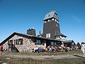
Hanskühnenburg

Big tubers

Bismarck Tower


Stages and circular hiking trails
The following stages are proposed on the official website:
- Stage 1: Bad Grund - Iberger Albert Tower - Lerbach (21.9 km, 724 meters in altitude )
- Stage 2: Lerbach - Hanskühnenburg - Sieber (18.8 km, 751 meters in altitude)
- Stage 3: Sieber - Großer Knollen - Bad Lauterberg (14.7 km, 731 meters in altitude)
- Stage 4: Bad Lauterberg - Bismarck Tower - Hausberg - Wiesenbeker Teich - Bad Sachsa (11.2 km, 556 meters in altitude)
- Stage 5: Bad Sachsa - Stöberhai station - Wieda (13.4 km, 471 meters in altitude)
- Stage 6: Wieda - Walkenried (16.7 km, 500 meters in altitude)
The following day tours are also signposted separately:
- No. 1: Bad Grund (7.6 km, 351 meters in altitude)
- No. 2: Lerbach (9.3 km, 542 meters in altitude)
- No. 3: Riefensbeek - Hanskühnenburg - Riefensbeek (17.1 km, 613 meters in altitude)
- No. 4: Sieber (11.3 km, 578 meters in altitude)
- No. 5: Scharzfeld (18.5 km, 518 meters in altitude)
- No. 6: Wieda - Stöberhai - Wieda (8.5 km, 364 meters in altitude)
Mountain bike
For well trained mountain bikers, it is possible to ride the entire Baudensteig in one day. The route is 96.7 km long and has 3733 meters of altitude, or in the opposite direction from Walkenried to Bad Grund, 3804 meters of altitude. The Baudensteig contains a relatively large number of single trails .
Web links
Individual evidence
- ↑ Directions on the official website of the Harzer Baudensteig , accessed on April 19, 2016
- ↑ Description of the circular hiking trails on the official website , accessed on April 19, 2016
