Hanskühnenburg
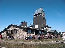
The Hanskühnenburg is a managed mountain hut in the western Harz . It stands at 811 m above sea level. NHN on the ridge " Auf dem Acker " in the middle of the Harz National Park and has a lookout tower. Its name comes from the legendary Hanskühnenburg cliff , 300 m northeast , which Johann Wolfgang von Goethe visited on August 14, 1784 . Opposite the observation tower is the Hanskühnenburg rock, which is relatively small compared to the cliff . A bronze plaque was attached to this in 1999 to commemorate Goethe's visit.
history
At the end of the 19th century, the Osterode branch of the Harz Club built a first wooden observation tower and a sheltered hut on the densely wooded Ackerkamm, which were inaugurated in 1889. The tower was unable to cope with the weather conditions and in 1912 had become so damaged that it had to be demolished. A year later, the Hanover branch began building a stone tower at the same location, which was completed in 1914.
The First World War brought the excursion traffic to a standstill and the management of the hut , which was far away from all settlements, had to be stopped. In 1922 the inn opened again.
In the meanwhile dilapidated building, management took place again from 1947, which had to be stopped in 1957 when the building and tower were closed by the building authorities. In 1958 the conditions were met to the extent that the blockage could be lifted; a fundamental renovation was not required. In 1971 the damage to the Hanskühnenburg was again so serious that the property was closed again. After emergency repairs, the tower and hut could be reopened in 1972.
The Harz Club did not have the necessary funds for a renovation of the property and in 1974 handed it over to the sponsorship of the district of Osterode , which started the renovation and expansion of the Hanskühnenburg. In 1975 the work for 500,000 DM was completed and building operations started again.
With the 13.5 km long farm trail completed in 1976, the Hanskühnenburg became a popular resting place for cross-country skiers in winter.
Since the 1960s, the forest on the arable ridge has been declining more and more as a result of forest dieback. Until then, the hut was hidden in dense forests, but today it is visible from afar. The tower offers a good panoramic view of the mountains of the Upper Harz . It is also the only place from which you can see the two former centers of Upper Harz mining, Clausthal and Sankt Andreasberg , at the same time.
The name Hanskühnenburg possibly goes back to Hans-Heinrich Kone (other spellings: Keune (n), Köhne, Kühne (n), Kramer), (* in November 1639 - † June 4, 1677), who became a partner from 1669 as a steelworks the Lonauer Eisenhütte and at the Lonauerhammerhütte . There was also another Hans Heinrich Keunen at the same time , who was called a Fuhrknecht.
Hiking trails
The Hanskühnenburg can be reached from all directions on a variety of hiking trails. Longer tours are available from Osterode over the city forest and Kammweg or along the Sösetalsperre . From the direction of Herzberg the ascent from Lonau takes place through the valley of the Großer Lonau (asphalt road) or the Siebertal . You have to overcome a similarly large difference in altitude when you hike up from Riefensbeek-Kamschlacken to the Baude. The easiest way to get there, however, is from the goldfinch corner on the Harzhochstrasse. There is a large parking lot and a bus stop there. From the goldfinch corner there are two ways to the Hanskühnenburg. The path on the east side, Ackerstraße, is a wide forest path with only one notable slope just before the hut. Hikers will find much nicer views, especially in the morning, along the riding path on the west side of the fields. However, this path is close to nature and therefore not easy.
The tower is only accessible during the opening times of the restaurant.
The Hanskühnenburg is included as no. 144 in the system of stamping points of the Harz hiking nobility. It is also at the highest point of the Harzer Baudensteig .
Web links
- Hanskühnenburg in the Harz Mountains (Homepage)
- Hanskühnenburg , history and legends , on harz-ausflug.de
- Hanskühnenburg (pictures), on hanskuehnenburg.blogspot.com
- Legends from Lower Saxony - Hans Kühnburg ( Project Gutenberg-DE ), on spiegel.de
Individual evidence
- ↑ Waldgaststätte Hanskühnenburg ( memento from October 24, 2016 in the Internet Archive ), accessed on April 28, 2011, from hanskuehnenburg-im-harz.de
- ↑ Map services of the Federal Agency for Nature Conservation ( information )
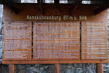
- ↑ Information board Hanskühnenburg on commons.wikimedia.org
- ^ Hans-Heinrich Hillegeist, The history of the Lonauerhammerhütte near Herzberg / Harz , Vandenhoeck & Ruprecht, Göttingen 1977, ISBN 3-525-36165-3 , pp. 44, 81-83
- ↑ Harzer Wanderadel: stamp point 144 / Hanskühnenburg , on harzer-wandernadel.de
Coordinates: 51 ° 43 ′ 41 ″ N , 10 ° 24 ′ 11 ″ E


