On the field
| On the field | ||
|---|---|---|
|
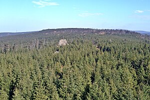
View from the tower of the Hanskühnenburg over the forest landscape of Auf dem Acker past the Hanskühnenburg cliff towards the northeast; the telecommunications tower at the goldfinch corner (left) and the Brocken (right) can be seen on the horizon |
||
| height | 865.1 m above sea level NHN | |
| location | Harz municipality-free area ; District of Göttingen , Lower Saxony ( Germany ) | |
| Mountains | Harz ( Upper Harz ) | |
| Dominance | 3.2 km → Bruchberg | |
| Notch height | 58.6 m ↓ at goldfinch corner | |
| Coordinates | 51 ° 44 '56 " N , 10 ° 26' 43" E | |
|
|
||
| rock | Acker Bruchberg Quartzite | |
In the field (also the short form field is common) in the community-free area Harz of the Lower Saxony district of Göttingen is a maximum of 865.1 m above sea level. NHN high ridge of the Upper Harz in the Harz low mountain range .
origin of the name
In various places it is claimed that the name Acker derives from the Middle High German Agger , which means comb or wall . So far, however, there is no well-founded reference to the source. On the other hand, Agger is a Latin word and means earth dam or earth wall , see Agger (fortification) .
Geographical location
The mountain ridge Auf dem Acker lies in the Upper Harz . Its high elevations are in the Harz National Park and most of its flanks in the Harz Nature Park . It begins southwest of the Bruchberg at Stieglitzecke ( 806.5 m ) on the federal road 242 and extends from there about 13 km in a south-westerly direction, with the first 6 km continuously reaching a height of more than 800 m . The outermost southwest foothills merge into the Harz foreland at Osterode am Harz . Together with the Bruchberg, the field forms the Acker-Bruchberg massif .
To the northwest of the ridge lies the Söse valley with the Sösetalsperre as well as the places Riefensbeek and Kamschlacken . To the south of the ridge are the places Lonau and Sieber . The Bergbaude Hanskühnenburg stands roughly in the middle of the ridge at an altitude of about 811 m .
National park and nature
The fields in the Harz National Park may only be entered on designated paths. Between the Hanskühnenburg and Stieglitzecke , parts of the ridge area consist of rain moor . This raised bog was largely destroyed by peat removal and drainage measures. Peat extraction continued until 1970. The Fastweg leading through the moor was closed in the mid-1990s shortly after the establishment of the national park to protect nature.
geology
The ridge consists largely of Acker-Bruchberg quartzite.
Cliffs and rocks
On the field , there are many cliffs and rocks. The following list contains an alphabetically sorted selection of cliffs and rocks - with height in meters (m) above mean sea level (NHN) and geographical location (⊙):
- Goldenkerklippe (max. Approx. 840 m ) ( ⊙ )
- Hammerstein cliffs (max. Approx. 780 m ) ( ⊙ )
- Hanskühnenburgfelsen (at approx. 815 m ), on the ridge of the Hanskühnenburg ( ⊙ )
- Hanskühnenburg cliff (at approx. 818 m ), on the ridge near the Hanskühnenburg ( ⊙ )
- Kanapeeklippe (max. Approx. 750 m ) ( ⊙ )
- Mönchskappenklippe (max. Approx. 680 m ) ( ⊙ )
- Seilerklippe (at approx. 760 m ), on the ridge, 1 km east of the Haspelkopf ( ⊙ )
- Sösestein (max. Approx. 730 m ) ( ⊙ )
- Sophienklippe (max. Approx. 650 m ), below the reel head ( ⊙ )
- Spießerklippe (max. Approx. 640 m ), below the reel head ( ⊙ )
- Stollen cliff (max. Approx. 690 m ) ( ⊙ )
![]() Map with all coordinates of the cliffs and rocks: OSM | WikiMap
Map with all coordinates of the cliffs and rocks: OSM | WikiMap
hike
At the northeastern end of the ridge at Stieglitzecke there is the Magdeburger Hütte refuge and a large parking lot. From there two hiking trails lead to the field , which are described in more detail in the article Hanskühnenburg . From the Hanskühnenburg the fast path “Nasser Weg” leads in a south-westerly direction along the ridge towards Osterode. Since the ridge is only sparsely overgrown with blueberries and small spruces, there are many vantage points with a wide view over the Harz Mountains and into the Harz foreland. One stage of the Harzer Baudensteig leads from Lerbach over the field to Sieber.
On or in the field there is a mountain hut , a Kote and two shelters , each of which is included in the system of stamping points of the Harz hiking pin - with height in meters (m) above sea level and geographical location (⊙; sorted in ascending order by stamping points Numbers):
- Kote am Schindelkopf (approx. 550 m ; ⊙ ; stamp number 143)
- Bergbaude Hanskühnenburg (approx. 811 m ; ⊙ ; stamp number 144)
- Morgenbrodtshütte at the Great Weir (approx. 604 m ; ⊙ ; stamp number 146)
- Refuge Waidmannsruhe (approx. 700 to 710 m ; ⊙ ; stamp number 148)
swell
- Topographic map 1: 25000, No. 4228, Riefensbeek (contains most of the ridge)
- Topographic map 1: 25000, No. 4227, Osterode am Harz (contains the southwestern foothills)
Individual evidence
- ↑ a b c d e f g Map services of the Federal Agency for Nature Conservation ( information )
- ↑ Hanskuehnenburg im Harz ( memento of October 24, 2016 in the Internet Archive ) (official Waldgaststätten homepage), on hanskuehnenburg-im-harz.de
- ^ Hans-Jürgen Beug , Irmtraud Henrion and Anneke Schmüser: Landschaftsgeschichte im Hochharz , Papierflieger Verlag, Clausthal-Zellerfeld 1999, ISBN 3-89720-256-5 , p. 64 and p. 173
- ↑ a b Harzer Wanderadel: stamp point 143 - Köte Schindelkopf ( memento from April 2, 2015 in the Internet Archive ) on harzer-wandernadel.de
- ↑ Harzer Wanderadel: stamp point 144 - Hanskühnenburg ( memento from April 2, 2015 in the Internet Archive ) on harzer-wandernadel.de
- ↑ Harzer Wanderadel: stamp point 146 - Morgenbrodtshütte ( memento from March 5, 2016 in the Internet Archive ) on harzer-wandernadel.de
- ↑ Harzer Wanderadel: stamp point 148 - Waidmannsruhe ( memento from February 11, 2013 in the web archive archive.today ) on harzer-wandernadel.de
Web links
- In the field , on harzlife.de
- The field , on harz-seite.de
- The Hammerstein cliffs on the Stieglitzeck in the Harz Mountains , description from the Lower Saxony State Office for Soil Research, on lbeg.de (PDF; 383 kB)


