Lerbach (Osterode am Harz)
|
Lerbach
City of Osterode am Harz
|
||
|---|---|---|
| Coordinates: 51 ° 45 ′ 31 ″ N , 10 ° 18 ′ 18 ″ E | ||
| Height : | 348 (300-400) m | |
| Residents : | 990 (Jul 1, 2012) | |
| Incorporation : | July 1, 1972 | |
| Postal code : | 37520 | |
| Area code : | 05522 | |
|
Location of Lerbach in Lower Saxony |
||
|
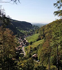
Panorama of the northern district
|
||
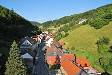
Lerbach is a valley and street village in the Upper Harz and part of the former district town of Osterode am Harz in the district of Göttingen in southern Lower Saxony , Germany . Until the regional reform in 1972 , the village was an independent municipality. Today the place has 990 inhabitants.
geography
location
Lerbach is located in the Upper Harz in the Harz Nature Park . It is located about 4 km northeast of Osterode am Harz in the direction of Clausthal-Zellerfeld at about 300 to 400 m above sea level. NN . The Söse - Lerbach tributary flows through the village .
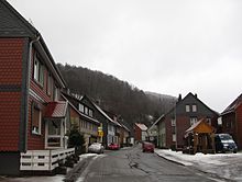
The federal road 241 leads northwest of Lerbach, from which the district road 26 branches off to the southwest of the village and runs for about 3 km as Friedrich-Ebert- Strasse through the village, to meet the B 241 a little northeast of it. From this through-town, side streets branch off to the left and right to the higher-lying locations. The Rote Sole , part of the Harzer Hexenstieg long-distance hiking trail, runs above the village . The Harzer Försterstieg also leads through Lerbach.
climate
The annual precipitation is 1106 mm and is thus in the upper third of the values recorded by the measuring points of the German Weather Service . Over 87% indicate lower values. The driest month is February; Most of the precipitation, in the form of snow, occurs in December. In December there is around 1.6 times more rainfall than in the driest month. The seasonal fluctuations in precipitation are in the upper third. In 71% of all places, the monthly precipitation fluctuates less.
|
Monthly average precipitation for Lerbach
Source:
|
|||||||||||||||||||||||||||||||||||||||||||||
history
Lerbach got its name from the Lerbach river , which flows through the valley along the village. It comes from a legend according to which a knight wanted to water his horse with water from the river on the way to Clausthal. Due to a drought, however, it was dried out, whereupon he is said to have said on the way back up the mountain: "Oh, you damn empty stream!". The origin of the name can still be found today in the town's coat of arms.
The Lerbach Valley was first settled around the year 1530. In old records, Lerbach is often called a mountain village, but the term "mountain" does not refer to the Harz mountains, but to mines. In 1551 a hammer hut ( smithy ) in Oberdorf was first mentioned in a document. The occurrence of Roteisenstein prompted iron stone miners and smelters to first build houses in the Bremketal and because of the greater water volume in the Lerbachtal. The miners work as "self-leaners" on their own wages. The extensive forests and forests of the Upper Harz also made charcoal burning and forestry possible, which were mainly used for the needs of mining.
From 1617 to 1823 Lerbach was under the supervision of the Clausthal Mining and Forestry Office, was a subsidiary of St. Aegidien in Osterode until 1728 and was later given its own pastor, church and cemetery. In 1737 Lerbach had 525 inhabitants and 76 houses. In 1789 an ironworks with a blast furnace was built.
The traffic by horse and cart led on the old Harzstraße as the most important connection over the western Harz from Osterode to Goslar past Lerbach. It was not until 1844 that the village, which had previously been accessed via the creek bed, was given a village road. In 1859 there were 123 houses and 1659 inhabitants.
The blast furnace operation of the Lerbacher Hütte was stopped in 1867. The hut operated a foundry until 1888. Their main task was to supply the Upper Harz mines and smelting works with machine castings, furnaces and other cast goods. In 1872 the Hüttenamt employed 190 and in 1912 133 workers. In addition to the foundry, there was an enamelling plant and a machine factory. In 1931 operations were stopped.
In the second half of the 19th century, iron stone mining in the Harz came to a standstill. As a result of the use of hard coal, the demand for charcoal produced by charcoal burning fell sharply, so that the coal piles in the forests became uneconomical and their operation was stopped.
A private savings bank was founded in 1820 from an earlier funeral fund, which existed until 2006 and until then was the oldest cooperative bank in Germany still in existence .
Around 1840, 1,312 people lived in 105 half-timbered houses that were all covered with wooden shingles.
Around 1850, doctors recognized that Lerbach's location was ideal for setting up a bathing resort and climatic health resort . In 1874 a bathing committee laid the foundation for tourism. In 1888 the Harz Club branch took over the care of paths and pavilions. 1897 was above the Kuckholzklippe the observation tower Kuckholzklippe built. In 1900 there were 205 spa guests and 1520 inhabitants. In 1931 an outdoor swimming pool was built, which was closed in 2008 due to the reduced number of visitors. From 2012 the swimming pool was dismantled and a nature adventure park was created at this point. A ski lift is available in winter. Until 2010 Lerbach was a resort .
In 1968 a bypass road was built as part of the federal road 241 , which leads past the village in the Lerbachtal valley above. As part of the municipal reform , Lerbach was incorporated into the city of Osterode on July 1, 1972 . Because it was part of the Zellerfeld district until then , it is now often referred to as Lerbach in the Upper Harz Mountains.
| Age structure in Lerbach | ||||||
| Age | 0-3 y | 4-6 y | 7-15 y | 16-18 y | 19-65 y | 65+ y |
|---|---|---|---|---|---|---|
| Residents | 21st | 21st | 65 | 25th | 628 | 268 |
politics
Local council
The local council consists of 11 councilors, including the honorary mayor.
After the local elections on September 11, 2016 , the following distribution of seats resulted (changes compared to 2011):
Local mayor
The local mayor is Frank Koch (SPD).
coat of arms
Blazon : “On green a knight on horseback; a red wavy line in the base of the shield. "
Economy and Infrastructure
traffic
The K 26 runs through Lerbach and joins the B 241 , which has two to four lanes, at both ends of the village .
The regular bus service in Lerbach is carried out by Regionalbus Braunschweig GmbH - Südniedersachsenbus . Several times a day, Lerbach can be reached by bus from Osterode and Clausthal-Zellerfeld.
education
- Primary school at Schwarzenberg (until 2012)
Attractions
- The Protestant church was built in 1728 and expanded to its present size in 1784 and 1823. In 2011 it was extensively renovated.
- The wooden bell tower was built in 1837 on a base made of rubble stones. The two bronze bells were used in 1974 and weigh 850 and 650 kg.
Personalities
Sons and daughters of the place
- Wilhelm Kolle (1868–1935), hygienist and bacteriologist, father of Kurt and Helmut Kolle and grandfather of Oswalt Kolle
- Heinrich Trull (1924–1996), naval officer and educator
Personalities who have worked on site
- Heinrich Pröhle (1822–1895), professor, teacher and writer
Others
- Lerbachite (Hg, Pb) Se, a mixture of Clausthalite and Tiemannite , was named locally after the place.
literature
- Heinrich Heine : The Harz journey . Hoffmann & Campe, Hamburg 1824 ( Gutenberg project ).
- Heinrich Pröhle: Harz sagas . tape 1-2 . H. Mendelssohn, 1859, p. 148 ( Preview in Google Book Search).
Web links
Individual evidence
- ↑ https://www.osterode.de/leben-in-osterode-am-harz/ortschaften/lerbach/
- ↑ Register of municipalities in the district of Zellerfeld from January 1st, 1945. Retrieved August 6, 2011 .
- ↑ Climate data from the DWD (1981-2010). Archived from the original on June 1, 2013 ; Retrieved February 20, 2014 .
- ^ Heinrich Pröhle: Harzsagen . tape 1-2 . H. Mendelssohn, 1859, p. 148 ( Preview in Google Book Search).
- ↑ Genossenschaftsverband eV - 190 years of tradition in Lerbach. (No longer available online.) March 2010, formerly in the original ; Retrieved September 21, 2012 . ( Page no longer available , search in web archives ) Info: The link was automatically marked as defective. Please check the link according to the instructions and then remove this notice.
- ^ W. Keil: Neumanns Orts- und Verkehrslexikon , S. 604. Leipzig 1905
- ↑ Osterode.de - Lerbach Nature Adventure Park , accessed on February 16, 2017.
- ↑ Lower Saxony State Parliament, 16th electoral period, printed matter 16/3359: Small question "What is the significance of predicates such as 'state-approved climatic health resort' especially for heath tourism and the tourism industry in Lower Saxony?" (PDF; 102 kB) February 16, 2001, accessed on August 6, 2011 .
- ^ Federal Statistical Office (ed.): Historical municipality directory for the Federal Republic of Germany. Name, border and key number changes in municipalities, counties and administrative districts from May 27, 1970 to December 31, 1982 . W. Kohlhammer GmbH, Stuttgart and Mainz 1983, ISBN 3-17-003263-1 , p. 215 .
- ^ Website of the Göttingen municipal services , accessed on October 1, 2016
- ↑ Hans Pusen : Resin, Hanover, Lüneburg Heath , 49. Munich 1982
- ↑ Memorial plaque in front of the tower
- ↑ Adolf Kenngott : Overview of the results of mineralogical research in the years 1862 - 1865 . Engelmann, 1868, p. 308 ( preview in Google Book search).


