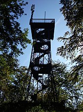
Kuckholzklippe observation tower
| Kuckholzklippe | |
|---|---|
| Tower type: | Observation tower |
| State : | Germany |
| Country : | Lower Saxony |
| County : | Goettingen |
| Location : | Lerbach |
| Location : | Edge of the Harz plateau |
| Geo coordinates : | 51 ° 45 '55.8 " N , 10 ° 18' 51.7" E |
| Site altitude: | approx. 565 m above sea level NHN |
| Tower height: | 15 m |
| Stairs: | 75 |
| Viewing platform : | approx. 580 m above sea level NHN |
| Inauguration : | August 1, 1897 |
The Kuckholzklippe observation tower stands on a southern mountain spur of the high plateau of the Harz low mountain range near the village of Lerbach in the non-parish Harz region of the Göttingen district in Lower Saxony .
Geographical location
The observation tower is located in the Upper Harz in the Harz Nature Park . It stands around 500 m north of the northern edge of the village of Lerbach , a district of Osterode am Harz through which the Lerbach flows , at the upper end of the rocky Kuckholz cliff at around 565 m above sea level. NHN . From the tower location, the landscape leads northeast to the Schieferberg ( 577.5 m ). To the west of the tower is the former Weghaus Heiligenstock , about 360 m north-north-west between Lerbach and Clausthal is the federal road 241 .
History and description
The Kuckholzklippe probably owes its name to a water hole at the foot of the cliff. It once served as the mountain cows drinking and was therefore Cow kolk called. From Kuhkolk , also the name of a side valley of the Lerbach valley below the cliff, the current term Kuckholz arose "probably only through an imprecise tradition" .
The observation tower was built from steel frameworks by the Royal Hüttenamt Lerbach for 2,625 Reichsmarks on behalf of the Harz Club branch associations from Buntenbock, Clausthal, Lerbach and Osterode and inaugurated on August 1, 1897. It is about 15 m high. In 1992 a renovation was carried out by the Harz Club for around 80,000 German marks . In 1994 the tower was declared a monument . Its upper viewing platform , which can be reached via 75 steps and is located at a height of around 580 m , offers space for 90 people.
Opportunities for viewing and hiking


From the upper viewing platform of the tower the view falls into the Harz landscape, including the Brocken , the nearby mountain ridge Auf dem Acker , over to Buntenbock , down to Lerbach and Osterode am Harz and into the Harz foreland.
The rocky Kuckholzklippe is included as no. 139 in the system of stamp sites of the Harz hiking nobility; the punch box hanging in the shelter Alfred Schiecke hut (also shelter Kuckholzklippe called; ⊙ ), the 1964 by Harzklub branch club Clausthal-Zellerfeld about 100 meters north-northwest of the observation tower in addition to at 569.1 m built point lying crossroads. The hiking trails Harzer Baudensteig and Harzer Försterstieg lead past . The tower can only be reached on forest and hiking trails, for example starting at small parking bays on the nearby B 241. It can also be visited from Lerbach on the Sommerbergweg - Moosholzweg axis and from the nearby Buntenbock parking lot at the Innerste - Prinzenteich reservoir .
About 500 meters south-southeast of the observation tower, below the Kuckholzklippe, on Kreisstraße 26 (B 241 – Lerbach – B 241) is the wooden observation pavilion Claras Höhe (approx. 440 m ), from which you can see Lerbach.
Individual evidence
- ↑ a b c d e f g h i j Photo of the information board for the Kuckholzklippe observation tower , on jensunterwegs.de
- ↑ a b c Kuckholzklippe or Kuhkolkklippe ? , on jensunterwegs.de
- ↑ a b Harzer hiking needle: stamp point 139 / Kuckholzklippe , on harzer-wandernadel.de
- ↑ Photo of the sign at the Alfred Schiecke Hut or Kuckholzklippe refuge , on jensunterwegs.de
- ↑ a b Map services of the Federal Agency for Nature Conservation ( information )

