
Bad Lauterberg in the Harz Mountains
| coat of arms | Germany map | |
|---|---|---|

|
Coordinates: 51 ° 38 ' N , 10 ° 28' E |
|
| Basic data | ||
| State : | Lower Saxony | |
| County : | Goettingen | |
| Height : | 296 m above sea level NHN | |
| Area : | 41.55 km 2 | |
| Residents: | 10,265 (Dec. 31, 2019) | |
| Population density : | 247 inhabitants per km 2 | |
| Postal code : | 37431 | |
| Area code : | 05524 | |
| License plate : | GÖ , DUD, HMÜ, OHA | |
| Community key : | 03 1 59 003 | |
| LOCODE : | DE SU | |
| City structure: | 4 districts | |
City administration address : |
Ritscherstraße 6–8 37431 Bad Lauterberg in the Harz Mountains |
|
| Website : | ||
| Mayor : | Thomas Gans ( SPD ) | |
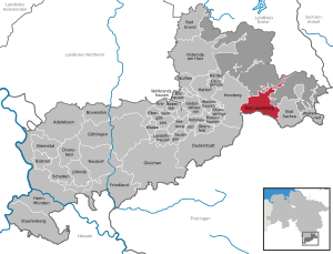
| Location of the city of Bad Lauterberg in the Harz Mountains in the Göttingen district | ||
  |
||

Bad Lauterberg im Harz is a town in the district of Göttingen in the south of Lower Saxony ( Germany ). The former mining town in the Harz Mountains is now a state-recognized Kneipp spa and Schroth spa town with over 10,000 inhabitants.
geography


location
Bad Lauterberg is located on the southern foothills of the Upper Harz Mountains and is surrounded all around by mountains of the Harz Nature Park , which in the area of the Stöberhai (unincorporated Harz region ) up to 720 m above sea level. High above sea level and covered by mixed forests; The Kummelberg ( 536 m ) and the Hausberg (approx. 420 m ) rise directly north of the city center, to the west of them the Heibeeksköpfe ( 465.2 m ) and to the east of the village the Scholben ( 575.1 m ) rises . The city is about 40 km from Göttingen and just under 72 km (as the crow flies ) from Braunschweig . It is 296 m above sea level on the Oder , into which the Lutter flows in Bad Lauterberg . To the north-east of the village is the Odertalsperre and to the south the Wiesenbeker Teich , a reservoir of the Upper Harz water reserve .
Neighboring communities
The neighboring communities include Herzberg am Harz in the west, Braunlage in the north and Bad Sachsa in the southeast .
City structure
Since the regional reform on July 1, 1972 , the city of Bad Lauterberg has been divided as follows:
- Bad Lauterberg (this includes the center, the Aue and the Oder Valley)
- Barbis (this includes Oderfeld, Altbarbis and Königshagen)
- Bartolfelde
- Osterhagen
etymology
The place name goes back to the Lutter river , which first gave its name to the mountain, then to the castle and finally to the settlement. This name is likely to be a derivation from Old Saxon hlûttar , which can be translated as "bright, pure, clear, louder".
The genesis of the toponym (in excerpts): 1183 “Luterberch”, 1324 “Lutterberg”, 1568 “Lautterberg”, from 1617 almost exclusively “Lauterberg”.
history

Construction of Lutterberg Castle
In 1183, Count Siegebodo II from Scharzfeld had Lutterberg Castle built on the local mountain. In 1202, around 20 years later, this was first mentioned in a document, along with other castles in the Harz region. The last count of Lutterberg Castle, Count Heidenreich III., Died in 1398, after which knight Hans von Minningerode occupied the castle for four years until it was finally handed over to the Count of Hohnstein . In 1415, Lutterberg Castle was completely destroyed as a result of a dispute between the Duke of Grubenhagen and the Count of Hohnstein and has not been rebuilt to this day.
see also Frauenstein Castle
Mining development
The County of Lutterberg was granted mountain freedom in 1521 , which gave the miners there special rights. This was to ensure that experienced miners from the Ore Mountains came to the city. A mining settlement grew out of the small town of Lutterdorf at the foot of the Hausberg. In 1619 the city received permission to hold a fair twice a year.
During the Thirty Years War , the city was looted and almost completely burned down in 1641. Only three houses were spared from the fire. After the reconstruction, the copper works in Luttertal were built in 1705 and the Königshütte works in 1733. The latter was expanded to include a foundry and a blast furnace in 1820. The foundry remained in operation until 2001. Copper mining ended at Lauterberg between 1830 and 1868. The mining of barite in the Wolkenhügel pit continued until June 2007.
Development into a spa town
As early as 1839, Ernst Ritscher recognized the need for alternatives to mining and created a cold water sanatorium. In 1900 there were 5004 spa guests and 5305 inhabitants. In 1866 the ten-year construction of the spa park began. Forty years later, the district government of Hildesheim named the place a bath and from then on bore the name Bad Lauterberg in the Harz region . Medical councilor Josef Mayer from Munich introduced Kneipp therapy in 1926 and later also the Schroth cure procedure . In the same year, the local Kneipp club was founded.
In the course of industrialization, various trades and companies settled here from the middle of the 19th century. Some of these had considerable numbers of employees. The following should be mentioned in particular: brush production (Adler, Richter, etc.); Chair and furniture production (Germania, Böhme, Blödhorn, Halthoff); Match production (Deig); Button making; Machine tool production (Kuhlmann); Steel and sheet metal processing (MIAG); Foundry and mill construction (Königshütte). The water power to be used by the slope of the Oder played a certain role as an energy source: up to the present day there are around five different water ditch systems.
In 1929 Bad Lauterberg received city rights. In the following year, work began on building the dam for the Oder dam, which was completed in 1934. At the end of the Second World War there was hard fighting for Bad Lauterberg, with 54 houses and 153 apartments being destroyed, which corresponded to a degree of destruction of 8%. The city was eventually captured by American troops, and then it became part of the British zone of occupation .
After 1945, the population grew significantly due to the influx of people who had been expelled from the east . Thousands of people from Silesia , Pomerania , the Sudetenland and East Prussia found a new home in the village. The Odertal community camp (foreign workers' camp), which was empty after the end of the war, played an important role in the settlement of the displaced. From 1949, many new residents were able to move into newly built apartments in multi-family houses in the Aue district with ERP funds. At the same time, many single-family houses were also built in the Aue. In order to use the potential of the refugees' labor force, a number of large and small production facilities were built in the period after 1945. The following are to be mentioned: DETA (accumulators); Fouchs (log houses); Drinks (insulation boards); Tailor (wood pulp); Dilinski joinery (cabinet systems).
In 1949 the spa town was officially designated the Kneipp spa and in 1968 it became a state-recognized Kneipp spa, and in 1982 it became a Schroth spa.
In 2008 the city celebrated its 825th anniversary.
Since the merger of the districts of Osterode am Harz and Göttingen on November 1, 2016, Bad Lauterberg in the Harz region has been part of the Göttingen district.
Incorporations
On July 1, 1972, the communities Barbis, Bartolfelde and Osterhagen were incorporated.
Population development
| Bad Lauterberg im Harz - population development since 1961 | ||||||
|---|---|---|---|---|---|---|
| year | Residents | change | year | Residents | change | development |
| 1961 | 14,832 | 2010 | 11,124 | - 5.06% |
 |
|
| 1970 | 14,573 | - 1.75% | 2011 | 11,080 | - 0.40% | |
| 1987 | 12,884 | −11.59% | 2013 | 10,671 | - 3.69% | |
| 1990 | 13,318 | + 3.37% | 2014 | 10,626 | - 0.42% | |
| 1995 | 12,901 | - 3.13% | 2016 | 10,548 | - 0.73% | |
| 2000 | 12,169 | - 5.67% | 2017 | 10,404 | - 1.37% | |
| 2005 | 11,717 | - 3.71% | ||||
| Population: 1961 on June 6th, 1970 on May 27th, each census results including the later incorporated places, thereafter each December 31st | ||||||
Religions

The historic St. Andrew's Church is located on the main street . In 1965/66, the St. Paulus Church was built in the west of the city, on Stollenweg, and a parish hall was added in 1972/73. The parishes of both churches belong to the Evangelical Lutheran parish of Herzberg. Further Evangelical Lutheran churches are located in the districts of Barbis, Bartolfelde and Osterhagen.
The Catholic St. Benno Church is located on Kirchberg. It was designed by Josef Fehlig and consecrated in 1963. As early as 1920, the Catholic Church bought a former school boarding school, which later became the Kneipp sanatorium St. Benno-Stift am Lönsweg. Services took place there until the inauguration of St. Benno Church. The parish hall of the parish was named after Joseph Müller , who had his first pastor's position in Bad Lauterberg. The parish belongs to the deanery Nörten-Osterode in the diocese of Hildesheim , today the Catholic churches in Bad Sachsa , Braunlage , Sankt Andreasberg and Walkenried also belong to it .
A New Apostolic Church is located on the street An den Lutterhöfen ; its congregation belongs to the Göttingen church district. As early as 1881, a New Apostolic congregation, which existed until 1993, was founded in what is now Bartolfelde.
politics
|
City council election 2016
Turnout: 54.59% (2011: 57.51%)
% 30th 20th 10
0
28.33%
25.83%
24.64%
9.05%
4.37%
3.49%
2.49%
1.80%
Gains and losses
compared to 2011
% p 30th 25th 20th 15th 10 5
0
-5 -10 -15 -7.72 % p
+ 25.83 % p.p.
-12.13 % p
-3.70 % p
-3.68 % p.p.
+ 0.46 % p
+0.69 % p
+ 0.26 % p
Remarks:
d Voting group Bürgerinitiative Bad Lauterberg eV
|
City council

The council of the city of Bad Lauterberg in the Harz currently consists of 20 councilors. The stipulated number for a parish with a population between 10,001 and 11,000 is usually 26 councilors. By resolution of the city council, this number has been reduced by six council members to 20 for the current electoral term. The council members are elected for a five-year term by local elections. The current term of office begins on November 1, 2016 and ends on October 31, 2021.
The full-time mayor Thomas Gans (SPD) is also entitled to vote in the city council.
The last local election on September 11, 2016 resulted in the following:
- CDU : 6 seats (−3)
- Voting group WgiR: 5 seats (+5)
- SPD : 5 seats (−4)
- Citizens' initiative Bad Lauterberg : 2 seats (−1)
- GREEN : 1 seat (−1)
- NPD : 1 seat (± 0)
mayor
The full-time mayor of the city is Thomas Gans (SPD). In the last mayoral election on September 11, 2011, he was elected with 44.5% of the vote. The turnout was 57.6%. Gans began his tenure on November 1, 2011.
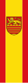
coat of arms
|
|
Blazon : “Divided by pewter cut of red and gold; on the battlements a striding, looking, blue-tongued and blue-armed golden lion, below on gold four red bars. " |
| Foundation of the coat of arms: The four places Lauterberg, Barbis, Bartolfelde and Osterhagen were in the former territory of the Counts of Lutterberg, who were significantly involved in the establishment of the settlements. The lion comes from the earlier count seal. The pewter cut symbolizes the two fortress sites Scharzfels and Lutterberg, which are now in the city area. The four red bars stand for the four places united in the unified municipality of Bad Lauterberg in the Harz Mountains. |
flag
The flag of the city of Bad Lauterberg is red and gold.
banner

Flag with coat of arms

Flag without coat of arms


The main statute of the city does not give any information about the exact design of the flag and banner.
Description of the banner and flag: "The banner is red-yellow-red in a ratio of 1: 3: 1 with longitudinal stripes with the coat of arms above the middle". "The flag is red and yellow striated with the coat of arms placed in the center to leech out easily moved." There are also flags without a coat of arms.
Culture and sights


Museums
- Scholmzeche visitor mine: The Eisenstein search tunnel Scholmzeche, built in 1837, was opened to visitors in 1989 and offers an insight into the mining of bygone times. During the tour is not only the Scholmzeche but also the galleries sincerity , were once mined copper ores, visited.
- Königshütte with the Südharzer Eisenhüttenmuseum: The site of the old Königshütte foundry is a special industrial monument that is unique in Northern Germany and gives an insight into the iron smelting of the last centuries. Guided tours can be used to explore the area with the old buildings and to see the ironworks museum set up there.
- Local history museum : In the local history museum, the over 800-year history of the city, from mining to the spa town, is documented and exhibited. The museum is located on Ritscherstrasse in the former home of Ernst Benjamin Ritscher , the founder of the spa.
Buildings

- Bismarck Tower : The 15 meter high observation tower has stood on the 536 m high Kummelberg since 1904 and is a popular hiking destination. There is a forest restaurant next door.
- The half-timbered town hall is located in the spa gardens.
- Bad Lauterberg Castle Cable Car on Hausberg : The valley station of the Bad Lauterberg Castle Cable Car is located in the city center near the church square . With a 63 percent gradient, it is one of the steepest in Germany, with a difference in altitude of around 111 meters. There is a restaurant with a terrace on the mountain.
- Dam of Odertalsperre : The Odertalsperre was put into operation in 1934 and since then dammed the waters of the Oder on. The dam is 53 meters high and 316 meters long. The Oder Reservoir is a popular destination as you can fish, sail, surf, swim and camp here. With the construction of the Oder Dam, the otherwise regular flooding of the Aue district ceased. As a result, a new district could arise there, which was intensively built on, especially after 1949.
- Wiesenbeker Teich : The Wiesenbeker Teich is another reservoir that was built in the early 18th century to power large water wheels for the mine honesty. It is part of the Upper Harz water shelf and is part of the World Heritage Site Rammelsberg Mine, Goslar Old Town and Upper Harz Water Management.
- St. Andrew's Church : The predecessor of today's church was built in 1571 and badly damaged in fires in 1641 and 1667. Since a spatial expansion was not possible due to a lack of space - the church is located on the main street in the city center - a second gallery was built in 1736 during a complete renovation of the church , which is supported by 52 wooden pillars. Since there was no space for a church tower, only a roof turret with a Welschen hood could be built, which was renewed in its original form in 1878. On this occasion the church received its splendid interior. During a renovation in 1911/1912, the church received its current colorful painting, which was renewed in 1957. Before that, the walls were simply white. In the Second World War, the church was damaged by artillery fire, so that the roof had to be completely replaced in 1957. Inside the church, the pulpit altar from 1736 is particularly noteworthy, the altarpiece is from the period after 1667. It shows a crucifixion group as well as the evangelists Lukas (with a bull) and Johannes (with an eagle). The evangelists Mark (with a lion) and Matthew can be seen next to the pulpit. The ceiling painting above the choir shows St. Andrew, the patron saint of miners. The organ from 1988 was inserted into the case from earlier times. There are four paintings on the parapet of the organ gallery, probably from the early 18th century. They show David and Jonathan as well as Joseph and the Pharaoh.
- Ritscher monument
- Former Bad Lauterberg train station. The half-timbered station building in the west of the city was originally in Hildesheim , where it stood at today's Hildesheim-Ost station . It was dismantled piece by piece at the beginning of the 1880s and then rebuilt and put into operation in Bad Lauterberg.
- 19th century granite eye source
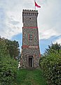
Bismarck Tower on the Kummelberg (Kummel)

Bergstadtlinde in the former town center

Eye source


Parks

- Bad Lauterberg Spa Park: The 20 hectare spa park, which was laid out 130 years ago, is very spacious and invites you to go for a walk and relax. The park can be crossed in many ways, past ponds and old trees. There are also playgrounds, a tennis court, water treading areas, a mini golf course, a historic fountain pavilion and an old concert pavilion . Several hotels border the park, the Kurhaus from 1910, the Haus des Gastes and the Oder River.
- Small Kurpark: The small Kurpark is a green area between Wissmannstraße, Sebastian-Kneipp-Promenade, Kurhaus and City Hall. The park contains the war memorial, a fountain and part of the mill ditch.
- Wissmannpark: In the Wissmannpark stands the bronze statue of the African explorer, officer and colonial official Hermann von Wissmann, created by the Berlin sculptor Johannes Götz and ceremoniously unveiled on September 4, 1908 in the presence of an official representative of the German Emperor . Wissmann liked to stay in Bad Lauterberg during his home stays because his mother lived there.
Streets and squares
- Main Street: The main street is the city's shopping street. It is designed as a traffic-calmed area or as a pedestrian zone on Saturdays and during special events. Here you will find a considerable range of shops, boutiques, cafes, pubs, bars, international restaurants and the like. a. A coffee roastery has also been located here since 2007. The main street and its side streets belong to the old town, which consists of many old half-timbered houses and narrow streets.
- Market square: The place officially called "Kirchplatz" is located directly on the main street and next to the St. Andreas Church. Annual events such as B. the wine festival or the Christmas village. Furthermore, the weekly market is held here every Friday.
music
- Music days
- Spa and special concerts
- Tea dance
- Nightbeat (music festival with live music in numerous pubs and bars)
The music label below average from Cologne had its origins in the Barbis district.
Sports
- Water sports: Several baths and lakes are available for tourists and locals to swim in. These include the Vitamar adventure pool, the Kirchbergtherme, the outdoor pool in Barbis or the Wiesenbeker pond . The large Oder dam can be used for other water sports such as sailing , fishing or surfing . The many water treading points that can be found in the spa park and on some forest paths are also to be emphasized.
- Hiking : There are hiking trails around Bad Lauterberg with a total length of around 120 kilometers. Viewpoints and restaurants can be found on several mountains. The paths are signposted and show the various hiking destinations with their respective distances. The well-known Karst hiking trail leads through Bad Lauterberg and its districts.
- Nordic walking : There are several Nordic walking trails signposted differently depending on the level of difficulty.
- Mountain biking: There are also numerous paths and routes for mountain biking.
- Winter sports: In the Haibektal, a side valley of the Luttertal, there is a ski run with a lift. There is also a cross-country ski trail that is connected to the Harz trail network.
- Tennis: There are a total of three tennis halls as well as several outdoor courts, u. a. also in the Kurpark or in Barbis.
- Soccer: There are several soccer fields in the city of Bad Lauterberg and in the districts of Osterhagen, Bartolfelde and Barbis.
- Fitness: There are several fitness centers in the city.
- Sports events: Once a year there is the winter night run, which takes place in the dark with snow. The paths are lit by the spectators with torches. Here you can run or walk.
Regular events
- Shooting festival
- Wine festival
- Spring and autumn happenings (shopping Sundays several times a year)
- Bad Lauterberg Christmas Village
- cozy carriage rides
- Night watchman tour
Economy and Infrastructure
economy
Both its idyllic valley location and the privilege of being a state-approved Kneipp spa and Schroth health resort make the city a popular destination for health resorts, holidays and excursions. For this reason, tourism is one of the main economic sectors. The number of spa guests rose from twelve to currently well over 100,000 annually, with around 600,000 overnight stays in the same period. As a result of health reforms and the decline in spa treatments, some hotels are now offering wellness treatments.
There are many health resorts, clinics, guest houses and several large hotels in the city. In total, there are more than 3800 beds in the city. In Bad Lauterberg you can also find the Kirchberg thermal baths and the well-known Vitamar indoor wave pool, which, thanks to its tropical climate, found its entry in the Guinness Book of Records , as bananas grow there. There is a campsite each at the Oder dam and at the Wiesenbeker pond. In the early 1980s, the latter was also in the Guinness Book of Records for the world's largest omelet.
Another important industry is retail. The city has an impressive shopping mile, which compared to the number of residents has a considerable number of shops and boutiques with a wide range of products to offer.
The larger companies in the city include B. Exide , which produces batteries for industrial trucks, automobiles and submarines, as well as the German barite industry Dr. Rudolf Alberti GmbH & Co. KG, which produces heavy spar products for the paint and varnish industry, the plastics and rubber industry as well as for modern floor coverings, glasses, brake linings and as sound insulation. Other large companies and employers are Hemeyer Verpackungen, Petrusky Stahlbau, Kunststoff-Fröhlich, Finstral, Wistoba Brush Factory and others. a.
Bad Lauterberg is also known for the Schierker Feuerstein and Harzer Grubenlicht liqueurs , which are also produced and bottled here.
education
The following schools are located in the municipality:
- Primary school on the Hausberg
- Barbis primary school (until 2016)
- Bartolfelde Elementary School (until 2015)
- KGS (Cooperative Comprehensive School) including Abitur level
The city also has a municipal library, which is located in the guest's house.
traffic


Rail transport
The Northeim - Nordhausen southern Harz line runs through the city . The breakpoint Osterode am resin Barbis each hour of regional trains of the DB Regio served. Buses provide the connection to the town center (lines 450 and 471), with a 10-minute walk to the bus stop in the direction of the town center. The old station Bad Lauterberg and the breakpoint Bad Lauterberg spa park in the center of Bad Lauterberg, at the earlier of Scharzfeld outgoing path toward Sankt Andreasberg were shut down in December 2004 for the passenger traffic, the railways in November 2007 removed. The Scharzfeld station on the outskirts of Scharzfeld was also closed in 2005 in favor of Barbis.
The aforementioned station is the first in Germany to have geothermal heated platforms. The installation of the heating cost 1.2 million euros.
Public transport
Bad Lauterberg is connected to the surrounding area with 2 bus connections. However, only line 450 also runs on Sundays and public holidays, and much more often. In addition to the Barbis district, line 471 also opens up the two remote districts of Bartolfelde and Osterhagen.
- 450: Herzberg am Harz - Scharzfeld - Barbis - Bad Lauterberg - Odertal - St. Andreasberg
- 471: Bad Sachsa - Steina - Osterhagen - Barbis - Bad Lauterberg
Road and bicycle traffic
Bad Lauterberg is on the federal highways 27 ( Blankenburg –Göttingen) and 243 ( Osterode - Nordhausen ). Since the end of 2008, the city has had a new suburban bypass (B 27), which relieves the Aue district from traffic. In order to improve the connection to the motorway network and to relieve the districts of Barbis, Bartolfelde and Osterhagen, the four-lane B 243 was rebuilt as a further bypass road; it crosses the Oder Valley Bridge and the Winkeltal Bridge and opens up the urban area via the junctions Barbis , Bad Lauterberg-West and Bad Lauterberg-South . This route was opened to traffic on September 5, 2014.
From Barbis in the west to the Oder dam in the east, there are one or more cycle paths on the 7-kilometer route. From the Odertalsperre down to Odertal there are cycle paths on the B 27. From Odertal to the Kurpark, the former railway line is used, from the Kurpark to the Aue exit there are cycle paths directly on the (former) B 27 (Wissmannstrasse and Bahnhofstrasse, Scharzfelder Strasse ). From there, Förstersteg or Oderfelder Straße continue to Barbis.
Personalities
sons and daughters of the town
- Georg Heinrich Hoffmann (1797–1868), mathematician, fireworker, artilleryman and teacher
- Adolf Heinrich Friedrich Schwarz (* 1812), doctor, 1848/50 member of the Mecklenburg Assembly of Representatives
- Hermann Schläger (1820–1889), member of the Reichstag and Landtag
- Alfred Ritscher (1879–1963), captain and polar explorer
- Walter Schnackenberg (1880–1961), painter and illustrator
- Henricus Halthoff (1888–1956), Mayor of Hanover, Frankfurt (Oder) and Cottbus
- Herbert Meyer (1899–1984), lawyer, administrative officer and local politician (NSDAP, FDP)
- Franz Abelmann (1905–1987), manager
- Hans Gärtner (1934–2014), classical philologist and medical historian
- Eberhard Umbach (* 1948), German physicist and science manager
- Bernd Langer (* 1960), former member of the autonomous scene
- Edgar Eduard Herbst (* 1961), photographer
- Constanze Wolter (* 1965), volleyball player
- Kai Peter Schmitz (* 1971), soccer coach
- Bibiana Steinhaus (* 1979), soccer referee
- Tino Schmidt (* 1993), soccer player
Personalities who worked or lived on site
- Friedrich August Crome (1757–1825), pastor at the Evangelical Lutheran Church of St. Andreas
- Ernst Ritscher († 1859), doctor, founder of Bad Lauterberg as a spa
- Franz Georg Ferdinand Schläger (1781–1869), pastor in Bad Lauterberg
- Hermann von Wissmann (1853–1905), German Africa explorer and governor of the colony of German East Africa (now Tanzania)
- Franz Kuhlmann (1877–1965), entrepreneur, founder of Kuhlmann KG with plants in Wilhelmshaven and Bad Lauterberg, honorary citizen of the city of Wilhelmshaven
- Joseph Müller (1894–1944), priest and martyr, 1931–1934 pastor in the Catholic parish of St. Benno, executed by the National Socialists in 1944
- Michael Müller (1975–2009), right-wing extremist German songwriter, lived in Bad Lauterberg
literature
- Carl Heinrich Edmund von Berg: Lauterberg am Harz and its surroundings , Clausthal 1841 ( digitized version )
Web links
- Website of the city of Bad Lauterberg in the Harz Mountains
- Link catalog about Bad Lauterberg in the Harz at curlie.org (formerly DMOZ )
- Harz - Info Harzer Tourismusverband eV
- Article Bad Lauterberg In: GenWiki.de
Individual evidence
- ↑ State Office for Statistics Lower Saxony, LSN-Online regional database, Table 12411: Update of the population, as of December 31, 2019 ( help ).
- ↑ Uwe Ohainski, Jürgen Udolph: The place names of the district of Osterode . Ed .: Göttingen Academy of Sciences. Publishing house for regional history, Bielefeld 2000, ISBN 3-89534-370-6 , p. 8-10 .
- ^ W. Keil: Neumanns Orts- und Verkehrslexikon. Leipzig 1905, p. 594.
- ↑ Lower Saxony city book. Braunschweig 1952.
- ↑ a b Federal Statistical Office (ed.): Historical municipality register for the Federal Republic of Germany. Name, border and key number changes for municipalities, counties and administrative districts from May 27, 1970 to December 31, 1982 . W. Kohlhammer GmbH, Stuttgart and Mainz 1983, ISBN 3-17-003263-1 , p. 215 .
- ^ Website of the Göttingen municipal services
- ^ Lower Saxony Municipal Constitutional Law (NKomVG) in the version of December 17, 2010; Section 46 - Number of MPs , accessed on March 15, 2015
- ↑ Municipal data processing center in southern Lower Saxony: quick report on the 2016 municipal elections on September 11, 2016 , accessed on September 29, 2016
- ↑ Individual results of the 2011 direct elections in Lower Saxony ( memento from December 26, 2014 in the Internet Archive ), accessed on March 15, 2015
- ↑ Main statutes of the city of Bad Lauterberg in the Harz Mountains , accessed on March 17, 2015
- ↑ Flag and banner of Bad Lauterberg in the Harz Mountains
- ↑ Jens-Uwe Brinkmann: Hildesheim - as it was. Düsseldorf 1976, p. 83.
- ^ Association of Friends of Art and Culture in Mining: The Cut. 1991, p. 243.
- ↑ Kristin Müller: The largest farmer's omelette in the world. In: harzkurier.de. Harz Kurier Verlag, July 7, 2017, accessed December 5, 2017 .
- ↑ Bernd Genath: That's how it is, Deutsche Bahn AG - Geothermal platform heating Bad Lauterberg fits well into the cliché (= Heizungsjournal . No. 3 ). 2011, p. 135-139 ( docplayer.org [accessed December 5, 2017]).
- ↑ OpenCycleMap
Adelebsen | Bad Grund (Harz) | Bad Lauterberg in the Harz Mountains | Bad Sachsa | Bilshausen | Lake Constance | Bovenden | Charging | Dransfeld | Duderstadt | Boar idols | Elbingerode | Friedland | Gieboldehausen | Same | Göttingen | Hann. Münden | Hattorf am Harz | Herzberg am Harz | Hörden am Harz | Jühnde | Krebeck | Landolfshausen | Niemetal | Obernfeld | Osterode am Harz | Jump | Rollshausen | Rosdorf | Rüdershausen | Scheden | Seeburg | Seulingen | Staufenberg | Waake | Walkenried | Wollbrandshausen | Wollershausen | Wulften am Harz
Community-free area in the district of Göttingen
Harz (district of Göttingen)