
Hausberg (Bad Lauterberg)
| Local mountain | ||
|---|---|---|
 View from the Bad Lauterberger Bismarck Tower on the |
||
| height | 420 m above sea level NHN | |
| location | Bad Lauterberg , Göttingen district , Lower Saxony , Germany | |
| Mountains | Harz ( Upper Harz ) | |
| Coordinates | 51 ° 37 '52 " N , 10 ° 27' 47" E | |
|
||


The local mountain in the Harz low mountain range is about 420 m above sea level. NHN high mountain in the urban area of Bad Lauterberg in the district of Göttingen ( Lower Saxony ).
geography
location
The local mountain is located in the Upper Harz in the Harz Nature Park . The wooded mountain rises directly north of the core town of Bad Lauterberg, between the Oder in the southeast and its tributary Lutter in the west.
Parts of the Harz landscape protection area (district of Göttingen) ( CDDA no. 321403; 2000 designated; 300.20 km² in size) lie on the mountain .
Natural allocation
The local mountain is part of the natural spatial main unit Middle Harz and the subunit Southern Middle Harz to the natural area Oderbergland (380.81). Its southern flank falls in the southwestern Harz foreland into the natural area of gravel fields of the Rhume , Oder and Sieber (376.23).
Lutterberg Castle
Lutterberg Castle (also called Lauterberg Castle ), which was built in 1183 and was destroyed in 1415 and never rebuilt, stood on the local mountain . Small remains of the curtain wall are still present.
Castle cable car and mountain restaurant
The Bad Lauterberg Castle Cable Car , which starts in the center of Bad Lauterberg , has been leading up to the local mountain since 1954 . At 63% maximum incline, it overcomes an altitude difference of around 110 m , making it one of the steepest double chairlifts in Germany. On the mountain is the Hausberg mountain restaurant with a wedding tower and a transmission mast next door .
Opportunities for viewing and hiking
Apart from a trip on the castle cable car, the top of the local mountain can only be reached on forest and hiking trails. From there, there is a particular view of Bad Lauterberg and the neighboring Harz Mountains.
gallery

View of the eastern part of Bad Lauterberg from the local mountain
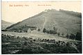
View of the local mountain (1907)


Individual evidence
- ↑ a b Topographic map Hausberg ( Memento of the original from March 4, 2016 in the Internet Archive ) Info: The archive link was inserted automatically and has not yet been checked. Please check the original and archive link according to the instructions and then remove this notice. , on natur-erleben.niedersachsen.de
- ↑ Map services of the Federal Agency for Nature Conservation ( information )
- ↑ Jürgen Spönemann: Geographical Land Survey: The natural spatial units on sheet 100 Halberstadt. Federal Institute for Regional Studies, Bad Godesberg 1970. → Online map (PDF; 4.7 MB)
- ↑ a b c Castle Cable Car (Homepage)
- ↑ Berggaststätte Hausberg (Homepage)